
Es Vedrà (Sant Josep, Ibiza)
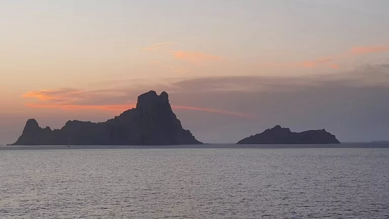
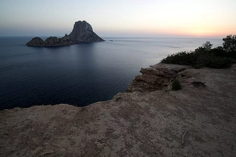
IslandEs Vedrà is the 382 m rock island off the south-west coast of Ibiza, in Sant Josep de sa Talaia, about 3.5 km from the beach at Cala d’Hort. You cannot land on it: Es Vedrà and its smaller neighbour Es Vedranell are a nature reserve, and going ashore needs an authorisation from the reserve. Most people see it from the cliffs and beach at Cala d’Hort, especially at sunset, or from a boat, since sailing, swimming and anchoring off Posidonia are allowed around it. It suits sunset watchers, boat owners, divers and birdwatchers; skip it if you were hoping to climb or walk on the island.
Quick facts
- Names: Es Vedrà is the Catalan name, also used by the Balearic government’s Spanish pages and in English. The smaller islet beside it is Es Vedranell.
- Where: off the south-west coast of Ibiza, municipality of Sant Josep de sa Talaia, facing Cala d’Hort.
- Coordinates: 38.8667, 1.1979.
- Height: 382 m (Balearic government); Es Vedranell is 128 m (Balearic Islands tourist board). OpenStreetMap names the summit Picatxo des Migjorn.
- Protection: part of the Es Vedrà, Es Vedranell and Illots de Ponent nature reserves, declared in February 2002 (Decree 24/2002), and a Natura 2000 site. The sea around Es Vedrà and Es Vedranell is a marine reserve.
- Landing: not allowed without authorisation.
- Sailing around it: free, no permit needed.
- Entry fee: none.
Access and parking
From land: there is no way onto the island, so “getting there” means getting to a viewpoint. The easiest is Cala d’Hort, about 10 km by road from the village of Sant Josep, following the signs; the beach looks straight out at Es Vedrà and Es Vedranell (Balearic Islands tourist board). OpenStreetMap shows a car park just behind the beach and a marked cliff-top viewpoint, “Es Vedra & Sunset view”, about 500 m south of the sand. Higher up, the old watchtower Torre des Savinar stands on the Puig des Savinar, about 2.8 km from Es Vedrà; OpenStreetMap marks a viewpoint there at about 240 m above the sea.
By bus: OpenStreetMap shows no bus stop near Cala d’Hort, so plan on a car, a taxi or a bike. See our Cala d’Hort guide for the beach road and parking.
By boat: the reserve can only be reached by sea, says the Balearic government: in your own boat, on a commercial boat trip, or on the activities run by the reserve itself. You do not need a permit to sail around the islets. We could not check which companies run sightseeing trips to Es Vedrà in 2026, or their prices.
What to expect
Es Vedrà rises straight out of the sea, steep on all sides. The Balearic government calls its silhouette one of the most emblematic images of the Pitiusas, the Ibiza and Formentera island group, and its height and rough shape make it a landmark you can see from far along the west coast. The tourist board describes the view at sunset from Cala d’Hort as the moment not to miss.
What you see from shore is the outside of a living laboratory. The reserve page lists 291 plant taxa on its islets, many of them endemic. One grows nowhere else in the world: the Es Vedrà chamomile (Santolina vedranensis). Es Vedrà also holds an important colony of Eleonora’s falcons, and its lizards, a local form of the Ibiza wall lizard, have blue and yellowish tones.
The reserve also covers the Illots de Ponent further north, off Sant Antoni (sa Conillera, s’Espartar, ses Bledes and others). Outside the summer season, the reserve says, boat trips in the area often see dolphins and sea turtles, and sometimes even a fin whale. The seabed is well preserved, with red gorgonians and Posidonia meadows.
The reserve’s education team runs guided sea and coastal trips, guided visits to sa Conillera, workshops and talks through the year, in small groups of 20–25. They are announced monthly on the reserve’s web page and Facebook page, and you must sign up in advance.
Practical details: rules on and around Es Vedrà
From the Balearic government’s reserve page and the reserve’s English leaflet (checked November 2026):
- Landing: not allowed on any of the islets without authorisation.
- Sailing: allowed, with no permit.
- Anchoring: free, including overnight, but never on Posidonia seagrass, which is forbidden by the Balearic Posidonia decree. Please keep the night quiet.
- Swimming and snorkelling: allowed. Diving in the marine reserve zones of Es Vedrà – Es Vedranell and ses Bledes needs a specific authorisation from the Balearic fisheries department.
- Fishing: recreational fishing from a boat is allowed under the marine reserve rules; spearfishing needs an annual authorisation. Collecting shellfish, sea urchins included, is forbidden.
- Not allowed: party boats, motorboat races, and jet skis, flyboards and water-ski run from seasonal rental stations. Lights that shine upwards or into the sea are also banned.
- Birds: the leaflet asks boats not to go close to the islets, especially in the breeding season from April to June.
- Photos and film: private photos are fine; commercial or advertising filming needs an authorisation.
Reserve office: Parc Insular de Serveis Sa Coma, Ibiza – Sant Antoni road km 3.4, Sant Rafel (tel. 971 17 76 88, ext. 3).
Accessibility and safety
The sand at Cala d’Hort is the easiest place to see Es Vedrà, but the road down to the beach is steep, and we could not confirm step-free access to the sand or to the cliff viewpoints. The cliff-top viewpoints have drops to the sea; keep back from the edge, especially at dusk when you walk back in fading light. At sea, check the forecast before taking a small boat out to the islets.
Best time to visit
Come for the sunset, which the tourist board singles out as the moment not to miss at Cala d’Hort. In summer, arrive well before sunset: the viewpoints and the small car park fill. For wildlife, the reserve says dolphins and turtles are easier to see outside the summer season. Boat owners should keep their distance from April to June, when seabirds and falcons are breeding.
Nearby alternatives
- Cala d’Hort, 3.5 km away: the beach facing Es Vedrà, with three seafood restaurants.
- Cala Comte, 11 km away: shallow sandy coves facing the Illots de Ponent, the other half of the reserve.
- Cala Saladeta, 18 km away: a small sandy cove near Sant Antoni.
- Dalt Vila, 21 km away: the walled old town of Ibiza.
- Ses Illetes, 24 km away on Formentera.
Distances are in a straight line from Es Vedrà.
FAQ
Can you go on Es Vedrà?
No. Landing on Es Vedrà, Es Vedranell and the other islets of the reserve is not allowed without an authorisation from the reserve. You can sail, swim and dive around it.
Where is the best place to see Es Vedrà?
Cala d’Hort beach and the cliff viewpoint just south of it, or higher up from the Torre des Savinar on the Puig des Savinar. All face the islet from the Ibiza coast.
How do I get to Es Vedrà?
Drive about 10 km from Sant Josep de sa Talaia to Cala d’Hort, following the signs; there is parking behind the beach. To get closer, go by boat: no permit is needed to sail around it.
How high is Es Vedrà?
382 m, according to the Balearic government. The smaller Es Vedranell next to it is 128 m.
Can you anchor and swim at Es Vedrà?
Yes. Anchoring is free, even overnight, as long as you do not drop anchor on Posidonia. Swimming and snorkelling are allowed; diving in the marine reserve zone needs a permit.
Sources and freshness
Checked 6 November 2026 · 4 sources Show
Checked 6 November 2026. Official: Balearic government, Es Vedrà, Es Vedranell and Illots de Ponent nature reserves (height, protection, landing, sailing, anchoring, diving, fishing, banned activities, wildlife, office, activities) and its English leaflet (breeding season, Natura 2000); Balearic Islands tourist board, Cala d’Hort (heights, sunset view, road from Sant Josep). Location, summit, viewpoints, Torre des Savinar, car park and distances: OpenStreetMap contributors (ODbL). Photos: Wikimedia Commons, licences as credited. Boat-trip operators and prices were not checked.
How this page is made. CostaMap is written with an AI editorial system run by Ebizapple. This page is based on the sources listed above. Last updated 6 November 2026. Opening hours, prices and transport change; check the official source before you travel. How we work · Partner links and ads