
Cala Saona (Formentera)
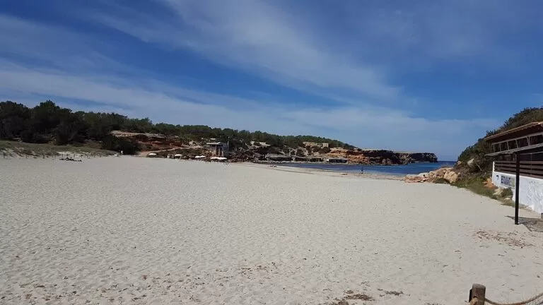
BeachCala Saona is the only sandy beach on Formentera’s cliff-lined west coast: a cove about 140 m long with turquoise water, red rock on both sides and some of the island’s best sunsets. It lies about 5 km in a straight line south-west of the ferry port of La Savina and 3.6 km from Sant Francesc; drive the road towards Cap de Barbaria and take the signed turning west, or follow the signed green routes by bike or on foot. It suits families, snorkellers, kayakers and anyone who wants a sunset swim; skip it in August if you dislike busy sand, as the tourist board ranks it among the island’s most popular beaches.
Quick facts
- Names: Cala Saona in Catalan and Spanish; on OpenStreetMap Platja cala Saona. “Cala” means cove.
- Where: west coast of Formentera (Balearic Islands), in a small bay between Punta Rasa to the south and Caló d’en Trull to the north.
- Coordinates: 38.6932, 1.3897.
- Length: barely 140 m, but quite wide (Formentera tourist board).
- Beach type: sand with a sandy seabed, flanked by low red cliffs and traditional boathouses.
- Facing: west, towards Ibiza and Es Vedrà.
- Distances (straight line): 4.9 km from La Savina, 3.6 km from Sant Francesc, 5.8 km from the Cap de Barbaria lighthouse.
Access and parking
By car or scooter: from Sant Francesc take the road towards Cap de Barbaria; about halfway along there is a signposted turning to the west. At the end of the tarmac there is a large car park with easy access to the beach (Formentera tourist board). OpenStreetMap maps two dirt car parks next to the hotel above the beach, one with space for about 50 cars, and a smaller dirt car park of about 25 spaces on the south side, marked as free. In high season, access to Formentera with a vehicle is regulated; check the current rules before you bring or hire a car (Formentera tourist board).
By bike or on foot from La Savina: green route 3, La Savina – Cala Saona, is 5.5 km and rated moderate: about 95 minutes on foot or 35 minutes by bike. It skirts the Estany des Peix lagoon and crosses the Porto-salè area through fields and dry stone walls before the cliffs (Formentera tourist board).
By bike or on foot from Sant Francesc: the route Sant Francesc – Ses Bardetes – Cala Saona is 3.7 km, rated moderate: about 65 minutes on foot or 20 minutes by bike, on dirt tracks past orchards, pine and juniper woods and farmed fields (Formentera tourist board).
By bus: OpenStreetMap shows a bus stop named Cala Saona on the access road, about 200 m from the sand. We could not confirm which line serves it or the timetable.
What to expect
The tourist board calls Cala Saona the jewel of the west coast. Unlike the open beaches elsewhere on Formentera, it is a small cove between cliffs. The first thing you see on arrival is the hotel above the beach; the sand itself is pale, the seabed sandy and the water turquoise, against the red soil and rock of the coast.
Because the bay is sheltered, local people built many boathouses here for their traditional boats, the llaüts. They still line the rock on the edges of the cove. OpenStreetMap marks a group of them, the Casetes Varador, on the south side.
The beach is busy in summer, but it is the place on the island to watch the sun go down over the sea. On clear days you can sometimes see the Spanish mainland from here, says the tourist board.
Activities on offer include paddle surfing, kayaking and snorkelling. A good trip by small boat or kayak is south to the cliffs of Punta Rasa, where there are underwater caves.
OpenStreetMap maps several restaurants and a beach kiosk around the cove. We did not check their opening dates.
Practical details
- Viewpoint: the Cala Saona viewpoint sits on the red cliffs about 150 m from the beach, with a view over the whole cove and the western sea. The tourist board says it is one of the best sunset spots on the island and advises arriving early (Formentera tourist board).
- Short walk: the Es Cap – Punta Rasa route is 2.2 km, rated easy (about 30 minutes on foot), through dry farmland with propped fig trees to the cliffs of Punta Rasa, with views of Es Vedrà, Ibiza and Cala Saona (Formentera tourist board).
- Posidonia: do not anchor on the seagrass; use the authorised buoy fields. Stay off the dunes and take your rubbish home (Formentera tourist board).
- Emergencies: 112. Formentera Hospital: +34 971 32 12 12; sea rescue: +34 900 202 202 (Formentera tourist board).
Accessibility and safety
The way down from the car park to the sand is short, but we could not confirm step-free access to the water or adapted facilities. The two beaches on Formentera that the tourist board lists as adapted for people with reduced mobility are Es Pujols and Es Arenals. Keep back from the cliff edges at the viewpoint and at Punta Rasa: they are sheer and unfenced in places. If you paddle to the caves, check the wind first and stay close to the shore. There is little natural shade on the sand.
Best time to visit
For swimming, May to October; the tourist board says May, June and September give the best balance of good weather and fewer people, and summer highs reach 28–31 °C (Formentera tourist board). Come in the morning for space on the sand, or in the evening for the sunset, which is when the cove is at its best. Arrive early in high season, as the car parks are small for the number of visitors.
Nearby alternatives
- Cap de Barbaria Lighthouse, 5.8 km: the lighthouse on the island’s dry southern cape, another sunset spot.
- Formentera, 4.1 km: our guide to the whole island.
- Migjorn beach, 6.8 km: the 5 km south-coast beach of Formentera, with Es Arenals.
- Es Pujols, 6.9 km: the island’s resort town and beach.
- Ses Illetes, 7.7 km: the island’s best-known beach, on the Es Trucadors peninsula.
- S’Espalmador, 10.8 km: the small island just north of Formentera.
Distances are in a straight line from the middle of the beach.
FAQ
How do I get to Cala Saona?
By car, take the road from Sant Francesc towards Cap de Barbaria and turn west at the signposted junction; the road ends at a car park above the beach. By bike, the green route from La Savina is 5.5 km and the one from Sant Francesc 3.7 km.
Is there parking at Cala Saona?
Yes. The tourist board says there is a large car park at the end of the road, and OpenStreetMap maps dirt car parks above and beside the cove. They fill early in July and August.
Is Cala Saona good for snorkelling?
Yes. The tourist board lists snorkelling, kayaking and paddle surfing, and recommends a boat trip to the underwater caves under the cliffs of Punta Rasa.
Is Cala Saona good for sunset?
Yes. It faces west, and the tourist board calls its sunset one of the best on Formentera. The viewpoint on the cliffs above the beach is the classic place to watch it.
How long is the beach?
Barely 140 m, according to the tourist board, though the sand is fairly wide.
Sources and freshness
Checked 9 November 2026 · 10 sources Show
Checked 9 November 2026. Official: Formentera tourist board (Consell Insular de Formentera) on Cala Saona beach (length, access, boathouses, activities, Punta Rasa caves), the Cala Saona viewpoint, the green routes La Savina – Cala Saona, Sant Francesc – Ses Bardetes – Cala Saona and Es Cap – Punta Rasa, where Formentera is and when to go, flora and fauna, health and safety and the adapted beaches on the Es Carnatge – Es Arenals route. Location, car parks, bus stop, restaurants and distances: OpenStreetMap. Not confirmed: bus line and timetable, restaurant opening dates, current vehicle rules.
How this page is made. CostaMap is written with an AI editorial system run by Ebizapple. This page is based on the sources listed above. Last updated 9 November 2026. Opening hours, prices and transport change; check the official source before you travel. How we work · Partner links and ads