
Cap de Barbaria Lighthouse (Formentera)
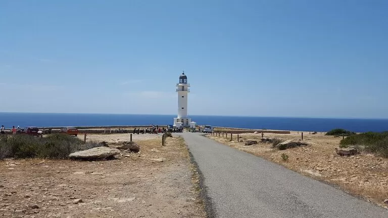
ViewpointThe Cap de Barbaria lighthouse (Far des Cap de Barbaria) stands on a 100 m vertical cliff at the south-western tip of Formentera, at the end of the PMV-820.1 road from Sant Francesc, 7.9 km away in a straight line. OpenStreetMap maps a gate that closes the last 1.6 km of road to motor vehicles in summer, so you park there and walk or cycle on. It is a bare, windy headland known for sunsets over Es Vedrà and for the lighthouse shot in the film “Lucía y el sexo”. It suits walkers, cyclists and sunset watchers; skip it if you want shade, a beach or facilities.
Quick facts
- Names: Far des Cap de Barbaria (Catalan), Faro del Cap de Barbaria or Faro de Barbaria (Spanish), Cap de Barbaria lighthouse. The cape is also spelled Cabo de Berbería in Spanish.
- Where: end of the Carretera de Cap de Barbaria a Sant Francesc (PMV-820.1), Formentera (Balearic Islands).
- Coordinates: 38.6411, 1.3895.
- Cliff: vertical, 100 m above sea level (Consell de Formentera). The light itself is 78 m above the sea.
- Built: planned in 1924, built in 1971; Formentera’s more modern lighthouse.
- Light range: 18 nautical miles.
- Entry: free. The official pages list no visits inside the lighthouse, and OpenStreetMap shows a locked gate at the lighthouse buildings.
- Facilities: none listed by the council or the tourist board. OpenStreetMap shows a bench, information boards, a bike rack and two emergency call points.
Access and parking
The route: from Sant Francesc, follow the PMV-820.1 south across the Cap de Barbaria plain. The last kilometres are a narrow road through dry scrub; OpenStreetMap shows a 30 km/h limit.
Summer closure to cars: OpenStreetMap maps a lift gate about 1.6 km before the lighthouse, tagged as closed to motor vehicles in summer and open to walkers and cyclists. We could not find the exact dates or hours of the closure on an official page, so check the signs when you arrive. Outside the closure you can drive to the lighthouse.
Parking: a free, unpaved car park sits right beside the gate (OpenStreetMap). From there it is about 1.6 km on foot along the road. A bike rack for 20 bikes stands about 80 m from the lighthouse.
On foot or by bike from further away: the council publishes three green routes that end here. Sant Francesc to Far de Barbaria via Ses Bardetes is 9.6 km, about 165 minutes on foot or 60 minutes by bike; Es Mal Pas to Far de Barbaria is 9.7 km (170 minutes on foot, 60 by bike); and Es Cap to Es Garroveret is 9.4 km (165 minutes on foot, 55 by bike). All three are graded medium (Consell de Formentera, green routes).
By bus: OpenStreetMap shows no bus stop near the lighthouse. Plan on a bike, a scooter, a car or a taxi to the gate.
What to expect
A flat, rocky headland with the white tower near the cliff edge. The island council calls it one of Formentera’s major landmarks: the southernmost rocky outcrop of the island and of the Balearic Islands, and the point closest to the coast of Africa. The vegetation is dry and sparse, low rosemary, fennel and thyme that can stand the strong winds. The council notes the area was once a forest, cut down for charcoal. On clear days you can make out the mountains of the mainland.
The lighthouse was planned in 1924 but only built in 1971. It has no other buildings around it (Illes Balears tourism). Its beam is seen from 18 miles away.
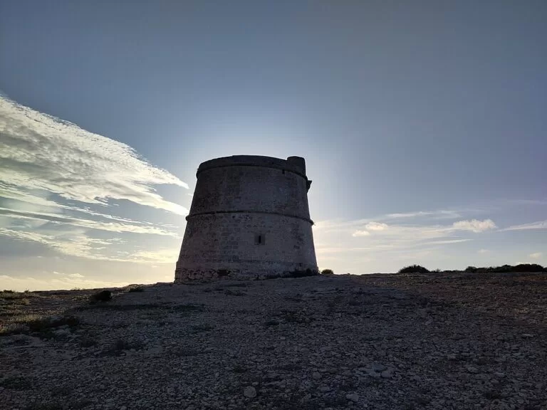
Torre des Garroveret: a coastal watchtower about 680 m north-east of the lighthouse along the cliffs. The council dates it to 1763: about 9 m high, on a cliff around 65 m above the sea, it is the southernmost tower on Formentera and a listed monument (Bien de Interés Cultural) (Consell de Formentera, Torre des Garroveret).
Bronze Age sites: on the way in you pass the signed archaeological sites of Cap de Barbaria I, II and III. The council says the area was densely settled in the early and middle Bronze Age, around 1600–1000 BC, with about twenty sites, three of them excavated and open to visit (Consell de Formentera). Cap de Barbaria I is right by the summer gate and car park.
Practical details
- Bring water and sun protection. There is no shade on the headland, and neither the council nor the tourist board lists a bar or kiosk.
- Tourist office: the Illes Balears listing gives turismo@formentera.es and +34 971 321 210 for information.
- Sunset crowds: the council says the cape is a meeting point for sunsets. Expect company in summer evenings.
Accessibility and safety
The headland is open, rocky ground next to a 100 m drop. OpenStreetMap maps a fence near the lighthouse “to prevent accidental falling”, but not along the whole cliff, so keep children close and stay back from the edge, especially in wind. Cova Foradada: about 70 m from the lighthouse a hole in the ground leads, by a ladder according to OpenStreetMap, into a cave that opens onto the cliff face. The council asks visitors to take special care there; the Balearic tourist board goes further and does not recommend visiting it, because it is not suited for visitors and may be dangerous. Emergency call points (112) are mapped near the lighthouse. We could not confirm any adapted access for wheelchair users while the summer gate is closed.
Best time to visit
The council recommends sunset, with the sun going down over the islet of Es Vedrà, and the Torre des Garroveret page also names sunset as one of the best moments. In summer that means a walk or ride back from the gate in fading light: bring a torch or bike lights. Spring and autumn are cooler for the walk in.
Nearby alternatives
- Far de la Mola, 17 km away: Formentera’s other big lighthouse, at the eastern end of the island, with an exhibition, café and car park.
- Formentera island guide, 8.2 km from the island’s centre point: ferries, getting around, beaches and villages, including Sant Francesc, 7.9 km away.
- Ses Illetes, 13.6 km away: the beach on the northern spit of the island.
- S’Espalmador, 16.4 km away: the small island off Formentera’s northern tip.
- Es Vedrà, 30.1 km away: the rock islet off Ibiza that you see at sunset from the cape.
Distances are in a straight line from the lighthouse.
FAQ
Can you drive to the Cap de Barbaria lighthouse?
Not in summer: OpenStreetMap maps a gate about 1.6 km before the lighthouse that is closed to motor vehicles in the summer season. Park at the free car park by the gate and walk or cycle the rest.
Is there parking at Cap de Barbaria?
Yes. A free, unpaved car park sits beside the summer gate, 1.6 km from the lighthouse. There is a bike rack for 20 bikes at the lighthouse.
Can you go inside the lighthouse?
The council and tourist board pages list no visits, exhibition or tickets here, unlike at the Far de la Mola. Plan on seeing it from outside.
Is the Cova Foradada safe to visit?
The Balearic tourist board does not recommend it: it is entered through a hole in the ground, is not suited for visitors and may be dangerous. The island council asks for special care.
Sources and freshness
Checked 6 November 2026 · 7 sources Show
Checked 6 November 2026. Official: Consell de Formentera on the Cap de Barbaria lighthouse (cliff, landmark, Cova Foradada, sunset, film), the Torre des Garroveret and its green routes Sant Francesc – Ses Bardetes – Far de Barbaria, Es Mal Pas – Far de Barbaria and Es Cap – Es Garroveret (distances, times, vegetation, Bronze Age sites); Illes Balears tourism on Lighthouse Cap de Barbaria (history, light height and range, Cova Foradada warning, contact). Location, summer gate, parking, bike rack, fence, emergency points and distances: OpenStreetMap contributors (ODbL). Photos: Wikimedia Commons, licences as credited.
How this page is made. CostaMap is written with an AI editorial system run by Ebizapple. This page is based on the sources listed above. Last updated 6 November 2026. Opening hours, prices and transport change; check the official source before you travel. How we work · Partner links and ads