
Platja de Migjorn (Formentera)
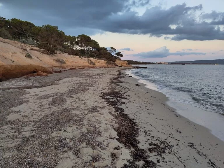
BeachPlatja de Migjorn is Formentera’s longest beach: about 5 km of sand coves and rocky stretches along the south coast, from Es Mal Pas in the west to Es Copinar in the east. It is reached by the many turnings south off the main road after Sant Ferran, on the way to La Mola, or by signed green routes from Sant Francesc, Sant Ferran and Es Pujols, and it lies about 7 km in a straight line from the ferry port of La Savina. It suits families, long beach walks and anyone who wants a seafood lunch on the sand; skip it if you want one compact beach with a village behind it.
Quick facts
- Names: Platja de Migjorn in Catalan, Playa de Migjorn in Spanish. Migjorn means “south” and is also the name of the whole south coast.
- Where: south coast of Formentera (Balearic Islands), between the Cap de Barbaria headland and the La Mola plateau.
- Coordinates: 38.6842, 1.4676 (the sand at Es Ca Marí, in the middle of the beach).
- Length: about 5 km, the longest beach on the island (Formentera tourist board).
- Sections, west to east: Es Mal Pas, Es Ca Marí, Es Racó Fondo, Es Còdol Foradat, Es Valencians, Es Arenals and Es Copinar.
- Adapted beach: Es Arenals has ramps, a shaded platform, handrails, amphibious chairs, lifeguards, adapted toilets and reserved parking.
- Distances (straight line): 6.9 km from La Savina, 4.5 km from Es Pujols, 4.4 km from Es Caló de Sant Agustí.
Access and parking
By car or scooter: take one of the many turnings to the south off the main road once you have passed Sant Ferran in the direction of La Mola (Formentera tourist board). Each section has its own access. Es Arenals is reached easily from the road towards La Mola and has free parking (Formentera tourist board). At Es Ca Marí, OpenStreetMap maps several small compacted and unpaved car parks within about 100–400 m of the sand. In high season, vehicle access to the island is regulated; check the current rules before you bring or hire a car.
By bike or on foot: the island’s signed green routes reach the beach from several directions (all from the tourist board’s route pages):
- Sant Francesc – Es Mal Pas: 2.8 km, easy, about 45 minutes on foot.
- Sant Ferran – Es Ca Marí: 2.3 km, easy, about 35 minutes on foot or 15 minutes by bike.
- Es Pujols – Es Ca Marí: 5.1 km, moderate, about 90 minutes on foot or 35 minutes by bike.
- Es Carnatge – Es Arenals: 1.5 km, moderate, about 25 minutes on foot, from around km 11 of the main road.
By bus: OpenStreetMap shows bus stops at Ca Marí and at the hotels behind the beach. We could not confirm lines or timetables.
What to expect
Migjorn is not one beach but a chain of coves with sand and rock in between, each with its own name and access. The tourist board says the most popular for swimming are Ca Marí, Es Arenals and Es Copinar, because their sandy seabed runs far out to sea. The shoreline changes from year to year: winter currents shape this coast, and stretches of sand can come and go.
Es Arenals is one of the busiest stretches. It has fine pale sand, dunes behind and shallow turquoise water where you can stand for many metres, with restaurants, beach bars, sunbed and kayak hire and lifeguards (Formentera tourist board).
The coast is lined with accommodation of all sizes, from apartments to small family hotels, plus seafood restaurants and beach bars, some of which stay open in the low season. Residents use this beach too; the tourist board calls the south coast the residents’ favourite area.
The tourist board says Migjorn is usually sheltered from the prevailing summer winds (Formentera tourist board), but its pages differ on which direction those winds blow from, so check the day’s forecast if wind matters to you. It is also a sunset beach, despite its south-facing orientation.
At the eastern end, past Es Arenals, the small wild cove of Caló des Mort sits under sandstone cliffs. It can only be reached on foot along a clifftop path with a risk of rockfalls, and has no facilities (Formentera tourist board).
Practical details
- Torre des Pi des Català: an 18th-century watchtower beside the beach at Es Mal Pas, built in 1762–1763 against pirate raids. It is the only tower on the island whose interior can be visited, after its restoration by the architect Marià Castelló in 2016 (Formentera tourist board).
- Can Blai: the foundations of a small late Roman fort, about 40 m per side, stand at km 10 of the road from La Savina to La Mola, about 1.7 km from the beach (Formentera tourist board).
- Emergencies: 112. Formentera Hospital: +34 971 32 12 12; sea rescue: +34 900 202 202.
Accessibility and safety
Es Arenals is one of the two beaches on Formentera adapted for people with reduced mobility, with access ramps, a shaded platform, handrails, amphibious chairs, lifeguards, adapted toilets and reserved parking (Formentera tourist board). The tourist board calls Migjorn safe for swimming, with shallow water and sandy bottoms, but some stretches are rocky and the shore changes each season. Do not walk to Caló des Mort along the cliff path if you are unsure on your feet: the tourist board warns of rockfalls. Shade on the sand is limited.
Best time to visit
For swimming, May to October; the tourist board says May, June and September give the best balance of warm weather and fewer people, and the sea reaches 26–27 °C in late summer (Formentera tourist board). In July and August arrive early at Es Arenals, the busiest stretch, or walk along the coast to the quieter coves. The beach bars and the length of the beach also make it a good walk out of season.
Nearby alternatives
- Formentera, 3.8 km: our guide to the whole island.
- Es Pujols, 4.5 km: the island’s resort town and beach.
- Ses Illetes, 8.3 km: the island’s best-known beach, on the Es Trucadors peninsula.
- Far de la Mola, 10.3 km: the lighthouse at the end of the La Mola plateau.
- Cala Saona, 6.8 km: the sandy cove on the west coast, known for sunsets.
- Cap de Barbaria Lighthouse, 8.3 km: the lighthouse on the island’s southern cape.
Distances are in a straight line from Es Ca Marí.
FAQ
How long is Migjorn beach?
About 5 km, the longest on Formentera. It is made up of several coves with their own names, from Es Mal Pas in the west to Es Copinar in the east.
Which part of Migjorn is best?
For swimming, the tourist board names Ca Marí, Es Arenals and Es Copinar, which have sandy seabeds running far out. Es Arenals has the most services and is adapted for people with reduced mobility.
Is there parking at Migjorn beach?
Yes. The tourist board says Es Arenals has free parking, and OpenStreetMap maps small car parks at Es Ca Marí and other access points.
Is Migjorn good for children?
Yes. The tourist board recommends it for families: it is usually sheltered from the summer wind and has shallow water and sandy bottoms, and Es Arenals has lifeguards.
How do you get to Migjorn from La Savina?
Drive the main road towards La Mola and turn south after Sant Ferran. By bike, ride to Sant Francesc or Sant Ferran and take the green routes to Es Mal Pas (2.8 km) or Es Ca Marí (2.3 km).
Sources and freshness
Checked 9 November 2026 · 13 sources Show
Checked 9 November 2026. Official: Formentera tourist board (Consell Insular de Formentera) on Migjorn beach (length, sections, access, services, wind), Es Arenals, Caló des Mort, the green routes Sant Francesc – Es Mal Pas, Sant Ferran – Es Ca Marí, Es Pujols – Es Ca Marí, Es Carnatge – Es Arenals (adapted beaches) and Sant Ferran – Cala en Baster – Migjorn, the Torre des Pi des Català, Can Blai and when to go. Also Spain.info on Formentera. Location, car parks, bus stops and distances: OpenStreetMap. Not confirmed: bus lines and timetables, beach-bar opening dates, current vehicle rules, the direction of the prevailing summer wind. Corrected 9 November 2026: removed the claim that the summer wind mostly blows from the east, because the tourist board’s pages contradict each other on it.
How this page is made. CostaMap is written with an AI editorial system run by Ebizapple. This page is based on the sources listed above. Last updated 9 November 2026. Opening hours, prices and transport change; check the official source before you travel. How we work · Partner links and ads