
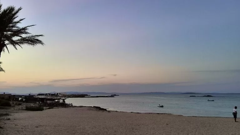
Es Pujols is Formentera’s main resort: a small seaside town on the north coast with a 690 m beach of white sand in front of the promenade, most of the island’s hotels and restaurants, its liveliest evenings and a night market on the seafront. It is about 3.6 km in a straight line east of the ferry port of La Savina; follow the road along the Estany Pudent lagoon, or turn north at Sant Ferran, or ride the signed green route from La Savina (5.6 km). It suits first-time visitors, families who want services on the beach and anyone without a car; skip it if you came to Formentera for silence.
Quick facts
- Names: Es Pujols; the beach is the Platja des Pujols in Catalan and the Playa de Es Pujols in Spanish.
- Where: north coast of Formentera (Balearic Islands), between the Estany Pudent lagoon and the Punta Prima headland, which OpenStreetMap places in Sant Ferran de ses Roques.
- Coordinates: 38.7240, 1.4583 (the beach).
- Beach: 690 m of sand backed by the promenade, with rock stretches, boathouses (escars) and small islets offshore (Formentera tourist board).
- Adapted beach: access ramps, a shaded platform, handrails, amphibious chairs and lifeguards.
- Tourist office: on s’Espalmador street, next to Miramar avenue, a few steps from the beach.
- Distances (straight line): 3.6 km from La Savina, 1.7 km from Sant Ferran, 4 km from Ses Illetes.
Access and parking
By road: the tourist board says Es Pujols is easy to find: follow the road that borders the Estany Pudent, or take the turning north in the village of Sant Ferran (Formentera tourist board). OpenStreetMap maps several small unpaved car parks within about 150–300 m of the beach, a parking entrance at Plaça d’Europa, and motorbike and bicycle parking near the seafront. In high season, vehicle access to the island is regulated; check the current rules before you bring or hire a car.
By bike or on foot: the green route La Savina – Sant Francesc – Es Pujols is 5.6 km, rated easy: about 85 minutes on foot or 30 minutes by bike. It goes round the Estany Pudent lagoon along the Camí des Brolls, past the salt flats, where flamingos and herons are common in winter (Formentera tourist board). From Sant Ferran, a 2.2 km route follows the old Camí de ses Vinyes between stone walls (Formentera tourist board).
By bus: OpenStreetMap shows bus stops on Carrer de Barcelona, including one named Platja des Pujols. We could not confirm lines or timetables.
What to expect
The tourist board is direct about it: tourism is the town’s main driving force. There is a wide choice of hotels and restaurants, from local dishes to international food, and the terraces with the best position overlook the sea. In the evening the bars and pubs in the streets behind the front fill up, and there is a small discotheque. Shops and boutiques focus on summer fashion.
The beach is the reason most people come. It is an urban beach but keeps clear turquoise water and white sand, with rocky stretches where the traditional boathouses stand and views north over a string of small islets. All services are close by: restaurants, cafés, ice-cream parlours, chemists, supermarkets and souvenir stalls (Formentera tourist board).
Next door are two quieter beaches. Ses Canyes, just south of Sa Roqueta, is a wide cove of sand and rock with low dunes, kept calm by the Es Pujols reef and good for small children and snorkelling, with no beach bar (Formentera tourist board). Sa Roqueta, about a kilometre away inside the Ses Salines natural park, has fine sand, dunes behind and few facilities; parking is limited (Formentera tourist board).
On summer evenings the seafront promenade becomes a night market with more than 40 stalls of clothing, handmade jewellery, ceramics, hats and espadrilles; entry is free, and the tourist board suggests going at sunset, before the crowds (Formentera tourist board).
Things to see nearby
- Ca na Costa: the megalithic tomb between the Estany Pudent and Es Pujols, about 750 m from the beach, dates from around 2000 BC and is the oldest megalith in the Balearic Islands. Its stone circles give it the local name Es Rellotge (the clock). Access is free (Formentera tourist board).
- Torre de Punta Prima: the largest of the island’s watchtowers, built in 1762 on the cliffs of the Punta Prima headland just east of the town. The interior cannot be visited, but the surroundings are open and the views reach Ibiza (Formentera tourist board). The Sant Ferran – Es Pujols – Punta Prima route (2.6 km) leads there.
Practical details
- Tourist office: the island council’s information point on s’Espalmador street gives free maps and brochures in many languages (Formentera tourist board). We did not check its opening hours.
- Pharmacy: Es Pujols pharmacy, +34 971 32 86 63. Formentera Hospital: +34 971 32 12 12. Emergencies: 112 (Formentera tourist board).
- Posidonia: do not anchor on the seagrass meadows; use the authorised buoy fields and stay on the walkways through the dunes.
Accessibility and safety
Es Pujols beach is one of the two on Formentera adapted for people with reduced mobility, with access ramps, a shaded platform, handrails, amphibious chairs and lifeguards (Formentera tourist board). The town is flat and compact. At Sa Roqueta the prevailing east winds of summer can raise a slight swell, and there are no lifeguards that we could confirm there or at Ses Canyes. Wear shoes on the rocky stretches.
Best time to visit
For swimming, May to October; the tourist board says May, June and September give the best balance of good weather and fewer people (Formentera tourist board). July and August are the busiest months, with the night market and the bars at full speed. In winter, the tourist board notes, some businesses on the island reduce their activity; Es Pujols, built for tourism, is much quieter then.
Nearby alternatives
- Ses Illetes, 4 km: the island’s best-known beach, reached by a 4.6 km route along Llevant beach.
- Formentera, 2.9 km: our guide to the whole island.
- S’Espalmador, 7.5 km: the small island off the northern tip.
- Migjorn beach, 4.5 km: the 5 km south-coast beach of Formentera, with Es Arenals.
- Far de la Mola, 12.8 km: the lighthouse at the eastern end of the island.
- Cap de Barbaria Lighthouse, 11 km: the lighthouse on the southern cape.
Distances are in a straight line from the middle of Es Pujols beach.
FAQ
Is Es Pujols a good base on Formentera?
Yes, if you want choice. The tourist board says it has the widest range of hotels and restaurants and the island’s nightlife, and it is 4 km from Ses Illetes and 3.6 km from the ferry port. For quiet, look at Sant Francesc, Migjorn or La Mola instead.
How do I get from La Savina to Es Pujols?
By road along the Estany Pudent lagoon, a short drive. By bike, the green route La Savina – Sant Francesc – Es Pujols is 5.6 km, about 30 minutes.
Is there parking in Es Pujols?
Yes, OpenStreetMap maps several small car parks near the beach and motorbike and bike parking on the seafront. They are small for August; a bike is easier.
When is the Es Pujols market?
It runs on summer evenings on the seafront promenade, with more than 40 stalls. We could not confirm the 2026 start and end dates.
Sources and freshness
Checked 9 November 2026 · 14 sources Show
Checked 9 November 2026. Official: Formentera tourist board (Consell Insular de Formentera) on the village of Es Pujols, Es Pujols beach (690 m, services), Ses Canyes, Sa Roqueta, the street market, the tourist office, Ca na Costa, Torre de Punta Prima, Sant Ferran, the green routes La Savina – Sant Francesc – Es Pujols and Sant Ferran – Es Pujols – Estany Pudent (adapted beaches), health and safety and when to go. Location, car parks, bus stops and distances: OpenStreetMap. Not confirmed: bus lines and timetables, market dates, tourist office hours, current vehicle rules.
How this page is made. CostaMap is written with an AI editorial system run by Ebizapple. This page is based on the sources listed above. Last updated 9 November 2026. Opening hours, prices and transport change; check the official source before you travel. How we work · Partner links and ads