
Binibeca Vell (Sant Lluís, Menorca)
VillageBinibeca Vell is a cluster of whitewashed holiday homes on the south-east coast of Menorca, built to look like an old fishing village around a small rocky inlet. It lies in the municipality of Sant Lluís, about 5 km from Sant Lluís village and 8 km from Maó: drive towards Binibeca Vell, park in one of the free car parks 175–200 m from the lanes, and walk in, or take bus 93 from Maó to the Poblat Pescadors stop. It suits anyone who wants a short walk through photogenic lanes and a swim nearby; skip it if you want a real working fishing port or dislike summer crowds.
Quick facts
- Names: Binibeca Vell is the name most visitors use. The official Catalan name is Binibèquer Vell; in Spanish it is Binibeca Viejo. The village core is also called the Poblat de Pescadors (fishermen’s village) de Binibèquer.
- Where: south coast of Menorca, municipality of Sant Lluís, postcode 07711. Between Cap d’en Font to the west and Binibeca beach to the east.
- Coordinates: 39.8231, 4.2298 (the village core, OpenStreetMap).
- Distances: 4.9 km by road from Sant Lluís (Balearic tourism portal); about 8 km from Maó (Wikipedia).
- Built: in the 1960s and early 1970s, designed by the architects Antoni Sintes Mercadal (1921–1981) and Francesc Joan Barba Corsini. Sources disagree on the exact years: Catalan Wikipedia gives 1964–1968 in one article and 1972 in another.
- Size: the village core covers less than one hectare (about 0.9 ha, measured on OpenStreetMap). The wider Binibèquer Vell settlement had 281 registered residents in 2025.
- Entry: free; no source we checked mentions a fee for walking through.
Access and parking
By car: from Sant Lluís, follow the road signs towards S’Ullastrar and then the signs for the Urbanización Binibeca Vell; the official Balearic tourism portal says you can park there and reach the shore by footpaths.
Parking: OpenStreetMap maps a street-side area called Parking Binibeca about 85 m from the village core, a free surface car park with 25 spaces about 175 m away, a second free car park about 200 m away, and more street-side parking about 300 m away. Some service roads and the car park right next to the houses are marked private. We could not find official figures for total capacity.
By bus: line 93 (Maó – Sant Lluís – Binibèquer, operator TMSA) stops at Poblat Pescadors, about 160 m from the village core, according to OpenStreetMap. The tourism portal says public transport runs to the Binibeca beach area in summer. We could not confirm the 2026 timetable or whether the line runs in winter.
On foot: the Camí de Cavalls coastal path (GR 223) passes within about 25 m of the village, so you can walk in along the coast.
What to expect
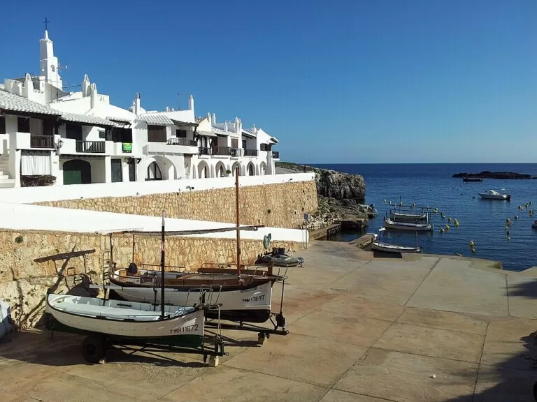
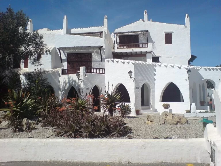
The village was designed to imitate a traditional fishing village that never existed on this spot (Catalan Wikipedia). The result is a small maze of narrow, paved lanes, white walls, arches, outside staircases and tall chimneys, with woodwork in natural colours. The style is different from traditional Menorcan building, and English Wikipedia notes that some people criticise it as inauthentic.
These are apartments and holiday homes, not a museum. Catalan Wikipedia describes a large number of apartments, a small supermarket and souvenir shops, and says the village is almost empty in winter and packed with visitors in summer. In May 2024 The Guardian reported that the village was threatening to close to tourists after a rise in visitor numbers (cited by English Wikipedia; we could not open the article). We could not confirm whether any visiting hours or restrictions apply in 2026, so follow any signs at the entrance, keep noise down and do not go into doorways or private terraces.
The houses look over a small rocky bay. The tourism portal describes it as a small bay between Cala Binissafúller and Caló Fondo, with views of the Escull de Sa Barca reef and the Illot de Binissafúller, low cliffs, and deep water over rock, sand and Posidonia seagrass that is good for snorkelling and diving.
Practical details
- Time needed: the core is small; a walk through the lanes is short. Add time for a swim or a meal.
- Food and shops: OpenStreetMap lists several restaurants and bars on and around Carrer des Timó and the Passeig Marítim (among them Sa Musclera, El Pescadito and El Patio), a supermarket, an ice-cream shop and an ATM. We did not check their opening hours; many places on this coast are seasonal.
- Toilets: OpenStreetMap shows a free public toilet near the village entrance, marked as not wheelchair accessible (last checked by mappers in 2022).
- Swimming: the inlet by the village is rocky with deep water. For sand, go to Binibeca Nou beach, about 1.1 km east in a straight line.
- Diving: OpenStreetMap shows a dive centre at Cala Torret, about 1.5 km east.
Accessibility and safety
The lanes are paved and lit, but the village is built on several levels. OpenStreetMap maps flights of steps (one of ten steps, with a handrail and no ramp), short passages under buildings and narrow footways. Not every lane is step-free. The public toilet is not wheelchair accessible. The rocks at the inlet are uneven and the water is deep close to the shore, so watch children. We found no lifeguard information for the inlet itself; OpenStreetMap marks Binibeca Nou beach as lifeguarded, but we could not confirm the 2026 season.
Best time to visit
Summer is the busiest time, and the village is almost empty in winter (Catalan Wikipedia). For photos without crowds, go early in the morning or in late spring and early autumn, when the sea is still warm enough for a swim. The tourism portal lists the bay as worth a visit in all four seasons.
Nearby alternatives
- Illa de l’Aire, 5.8 km away: the flat island with a lighthouse off Punta Prima, also in Sant Lluís.
- Camí de Cavalls, 8 km away: Menorca’s 185 km coastal trail, which passes right by the village.
- Maó Harbour, 8.1 km away: the island capital and its long natural harbour.
- Cala Mitjana, 25.2 km away: a south-coast cove near Ferreries.
- Binibeca Nou beach, 1.1 km east: a 400 m sandy beach with pines behind it and, in summer, a beach bar and sunbed rental (tourism portal).
Distances are in a straight line from the village.
FAQ
How do I get to Binibeca Vell?
By car from Sant Lluís (4.9 km): follow the signs to S’Ullastrar and then to Binibeca Vell. By bus, line 93 from Maó stops at Poblat Pescadors, about 160 m from the village; check the current timetable before you travel.
Is there parking at Binibeca Vell?
Yes. OpenStreetMap shows free car parks 175–200 m from the village, one with 25 spaces, plus street-side parking 85–300 m away. Some spaces next to the houses are private.
Do you have to pay to visit Binibeca Vell?
No. No source we checked mentions an entry fee. People live and stay in the houses, so be quiet and respect private doorways and terraces.
Can you swim at Binibeca Vell?
The inlet beside the village is rocky with deep water, good for snorkelling. For a sandy beach, Binibeca Nou is about 1.1 km east and has shallow, clear water.
Is Binibeca Vell a real fishing village?
No. It was designed in the 1960s–70s by the architects Antoni Sintes Mercadal and Francesc Joan Barba Corsini to look like one. It is a holiday-home complex.
Sources and freshness
Checked 6 November 2026 · 9 sources Show
Checked 6 November 2026. Official: Balearic Islands tourism portal on the Binibeca Vell bay (location, access, seabed, distance from Sant Lluís) and Binibeca Nou beach (length, facilities, summer public transport); Spain’s tourism portal on Sant Lluís. Background: Catalan Wikipedia on Binibèquer Vell and the Poblat de pescadors (architects, dates, apartments, seasonality), English Wikipedia (names, criticism, Guardian 2024 report) and Spanish Wikipedia. Location, parking, bus stop and line 93, toilets, steps, restaurants and distances: OpenStreetMap contributors (ODbL), including node 482752996 (population 2025). Photos: Wikimedia Commons, licences as credited.
This place is part of our Balearic Islands travel guide: Mallorca, Menorca, Ibiza and Formentera — see every town, beach and cove we have mapped on that coast.
How this page is made. CostaMap is written with an AI editorial system run by Ebizapple. This page is based on the sources listed above. Last updated 6 November 2026. Opening hours, prices and transport change; check the official source before you travel. How we work · Partner links and ads