
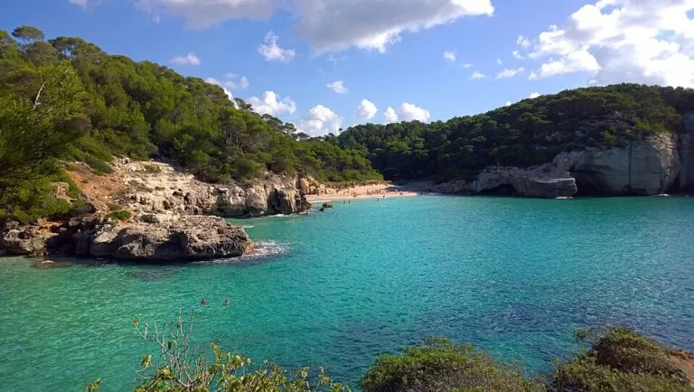
Cala Mitjana is an unspoiled white-sand cove on the south coast of Menorca, in the municipality of Ferreries, just east of Cala Galdana. From Ferreries (9.3 km) follow the signs to Cala Galdana and take the turn-off to Cala Mitjana; from the free car park it is a walk of about 20 minutes through pine woods, or 1.5 km on the Camí de Cavalls coastal path from Cala Galdana. There are no services on the beach. It suits swimmers, snorkellers and walkers who bring their own food and water; skip it if you need a bar, sunbeds or a lifeguard.
Quick facts
- Names: Cala Mitjana (Catalan, used in English and Spanish). Not to be confused with Cala Mitjana on Mallorca. Its tiny neighbour is Cala Mitjaneta.
- Where: south coast of Menorca, municipality of Ferreries, between the Penyal Alt de s’Anglès and es Pont de n’Aleix, about 1.2 km east of Cala Galdana.
- Coordinates: 39.9345, 3.9727.
- Size: 90 m long; the Balearic tourist board gives 140 m deep, spain.info 75 m.
- Sand: white, with calm water.
- Protection: part of a protected natural area that runs from Binigaus to this beach.
- Services: none on the sand; public toilets near the path and at the car park (OpenStreetMap).
- Entry and parking: free.
Access and parking
By car: from Ferreries (9.3 km), follow the road signs to Cala Galdana and take the turn-off to Cala Mitjana, says the Balearic Islands tourist board. The nearest main road listed by spain.info is the Me-22.
Parking: OpenStreetMap shows the free “Park Cala Mitjana” gravel car park beside the Cala Galdana roundabout, about 750 m in a straight line from the sand. The track from there to the beach, the Camí de Cala Mitjana, is closed to cars. English Wikipedia puts the walk from the car park at about 20 minutes. We could not confirm the number of spaces or any summer access control.
By bus: the “Cala Galdana – Rotonda” stops are next to the car park, about 800 m from the beach. OpenStreetMap maps TMSA lines 51 (Maó), 52 (Ciutadella) and 53 (Ferreries) to Cala Galdana. We could not open the 2026 timetables, so check before you go.
On foot: from Cala Galdana, follow the Camí de Cavalls (GR 223) east for 1.5 km. The tourist board recommends proper footwear.
What to expect
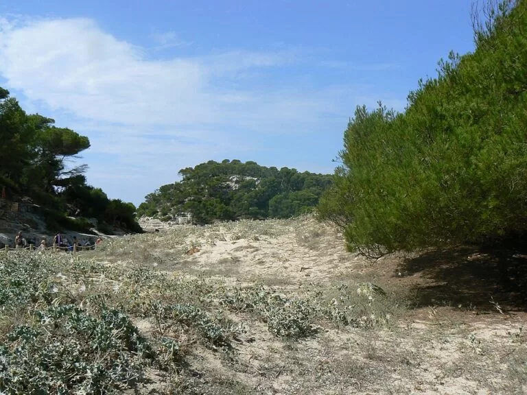
The beach sits at the end of a narrow inlet between pale limestone cliffs topped with pines. The tourist board describes crystal-clear water over a bright sandy bottom. Behind the sand are low dunes and then pine wood; the walk in passes picnic tables in the shade (Catalan Wikipedia).
The protected area is home to birds, bats, frogs, toads and shrews (tourist board). Dry Posidonia seagrass often piles up on the sand. Catalan Wikipedia notes it is a sign of clean water and should be left in place.
Cala Mitjaneta, a smaller cove on the west side of the same inlet, is about 200 m away. Catalan Wikipedia says it can only be reached on foot from the Camí de Cavalls (or by boat).
Spain.info rates occupancy as high, and English Wikipedia says the beach is very busy in the summer season.
Practical details
- Bring: water, food and shade. The tourist board is clear that the beach has no services.
- Toilets: OpenStreetMap marks free public toilets about 140 m from the beach, mapped as wheelchair accessible, and more at the car park.
- Snorkelling: best along the rocks on both sides of the inlet.
- Dunes: keep to the path; dune plants are fragile.
- Nearest marina: Club Náutico Cala Galdana, 2.4 km away (spain.info).
- Food and drink: the nearest bars and restaurants are in Cala Galdana.
Accessibility and safety
There is no lifeguard: spain.info lists only cleaning and a telephone as services. The walk from the car park is on an unpaved track and paths through dunes; we could not confirm step-free access to the sand. Catalan Wikipedia mentions a natural rock ledge of more than five metres near the path that people use to jump into the sea; depth and entry points are not marked, so jumping is at your own risk. Carry enough water in summer: there is nowhere to buy any on the beach.
Best time to visit
May, June and September give warm days and fewer people. In July and August arrive early in the morning, both for a space in the car park and on the sand.
Nearby alternatives
- Cala Mitjaneta, 200 m west: a tiny cove in the same inlet, on foot only.
- Cala Galdana, 1.2 km west: a larger resort beach with bars, restaurants and buses.
- Naveta des Tudons, 10.3 km away: a prehistoric burial monument in the west of the island.
- Maó Harbour, 25.7 km away: the long natural harbour of Menorca’s capital.
Distances are in a straight line from the beach.
FAQ
How do I get to Cala Mitjana in Menorca?
Drive towards Cala Galdana from Ferreries and take the signed turn-off to Cala Mitjana, then walk in from the car park. Or walk 1.5 km east from Cala Galdana on the Camí de Cavalls.
Is there parking at Cala Mitjana?
Yes. OpenStreetMap shows a free car park by the Cala Galdana roundabout, about 750 m from the beach; the track to the sand is closed to cars.
How long is the walk to Cala Mitjana?
About 20 minutes from the car park, or 1.5 km on the coastal path from Cala Galdana.
Are there toilets or a bar at Cala Mitjana?
There are public toilets near the path and at the car park, but no bar, shop or sunbeds. Bring food and water.
Can you swim at Cala Mitjana?
Yes. The water is calm and clear, but there is no lifeguard.
Sources and freshness
Checked 6 November 2026 · 5 sources Show
Checked 6 November 2026. Official: Balearic Islands tourist board, Cala Mitjana (Ferreries) (location, size, wildlife, services, road and coastal path); spain.info, Cala Mitjana (size, sand, occupancy, services, marina). Background: Catalan Wikipedia (Cala Mitjaneta, picnic area, rock ledge) and English Wikipedia (walking time). Location, car park, track, toilets, bus stops and lines, and distances: OpenStreetMap contributors (ODbL). The Ferreries town hall, Consell de Menorca and Menorca bus websites could not be reached from our research tools. Photos: Wikimedia Commons, licences as credited.
This place is part of our Balearic Islands travel guide: Mallorca, Menorca, Ibiza and Formentera — see every town, beach and cove we have mapped on that coast.
How this page is made. CostaMap is written with an AI editorial system run by Ebizapple. This page is based on the sources listed above. Last updated 6 November 2026. Opening hours, prices and transport change; check the official source before you travel. How we work · Partner links and ads