
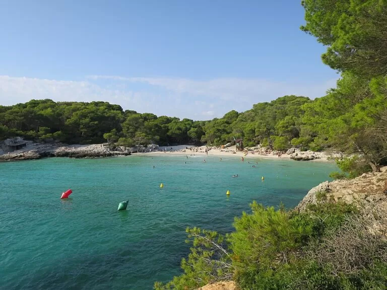
Cala Turqueta (Cala en Turqueta) is a white-sand cove on the south coast of Menorca, reached by a signposted road from Ciutadella (16.5 km) and a walk of about 850 m from the car park, according to the Balearic tourist board. The beach is about 100 m long, split in two by a low rock barrier, and backed by pine-covered cliffs inside the Costa Sud de Ciutadella protected area. There is no bar or shop, so bring water and food. It suits families and swimmers who arrive early; skip it in high summer if you cannot get there before the car park fills and the road is closed.
Quick facts
- Names: Cala Turqueta, Cala en Turqueta or Cala d’en Turqueta (Catalan). The name recalls the Turkish pirates who used to attack and land here.
- Where: south coast of the municipality of Ciutadella de Menorca, between the points of Es Tambors and Na Foradada.
- Coordinates: 39.9325, 3.9150.
- Size: about 100 m long; spain.info gives 100 m by 50 m.
- Sand and water: fine white sand, clear turquoise water, usually calm with small waves.
- Protection: part of the Àrea Natural d’Especial Interès (ANEI) of the Costa Sud de Ciutadella.
- Facilities: no bar or shop. Free toilets are mapped just behind the beach and a shower by the car park.
- Entry: free. The car park is marked free on OpenStreetMap.
Access and parking
By car: from Ciutadella, follow the road signs for Cala en Turqueta; the Balearic tourist board gives 16.5 km by road. The route uses the Camí de Sant Joan de Missa, the same road that continues to Cala Macarella (tourist board, Macarella).
Parking: the car park sits about 850 m from the beach (tourist board). OpenStreetMap maps it as a free gravel car park named Cala en Turqueta. In summer, the board advises coming early: when the car park is full, the access road is blocked to further cars. We could not confirm whether a fee applies in 2026.
By bus: OpenStreetMap maps a bus stop called Cala en Turqueta next to the car park. We could not reach the bus operator’s or the Consell de Menorca’s pages, so we cannot give the 2026 line, season or times.
On foot: the Camí de Cavalls coastal path passes the cove. OpenStreetMap places Platja des Talaier 1.2 km to the west and Cala Macarella about 2 km to the east on the same path.
What to expect
The beach lies at the end of a 400 m long inlet. A low rock barrier divides it into two halves, and towards the rocky sides there are more small patches of sand. Pine woods come down to the back of the beach, and spain.info notes that the cove is hidden among pine trees. The tourist board describes the water as very clear, with turquoise tones and little waves.
Catalan Wikipedia notes that the cliffs shelter the cove from northerly winds and that the water is shallow, which also makes it a refuge for small boats when the north wind blows. A buoyed area separates swimmers from water sports and small boats at anchor.
Spain.info calls it one of the most popular beaches on Menorca, and the tourist board warns that the car park can fill in summer.
Practical details
- Bring drinking water and food: the tourist board says the beach has no services such as a bar.
- Spain.info lists toilets, litter bins and cleaning. OpenStreetMap maps free chemical toilets just behind the beach and a shower by the car park.
- Spain.info calls the cove good for swimming and diving; the tourist board points to the clearest water towards the rocky sides.
- Take your rubbish back with you. The cove is inside a protected natural area.
Accessibility and safety
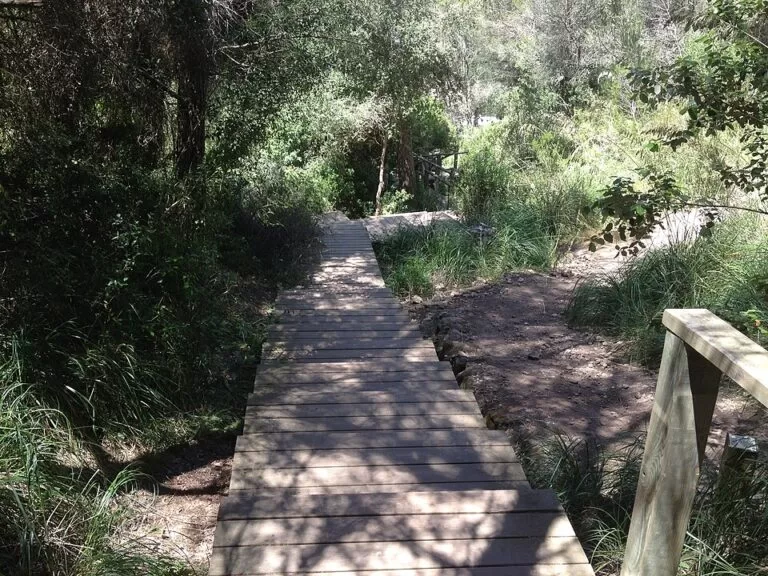
The walk from the car park is about 850 m on a path, partly on a wooden boardwalk (see the photo in this guide); we could not confirm step-free access all the way to the sand. OpenStreetMap marks the toilets behind the beach as wheelchair accessible. OpenStreetMap also marks the beach as supervised, and a lifeguard chair is visible in a 2017 photo, but we could not confirm the 2026 lifeguard season. Stay inside the buoyed swimming area, away from boats.
Best time to visit
Arrive early in the morning in summer: the tourist board warns that the road is blocked once the car park is full. Spring and autumn are quieter, and the beach is sheltered from northerly winds, so it is a good choice on a day of northerly wind.
Nearby alternatives
- Platja des Talaier, 1.2 km west on the Camí de Cavalls: a sandy cove further along the same coast.
- Cala Macarelleta, 1.7 km east: a small nudist-friendly cove reached on foot from Cala Macarella.
- Cala Macarella, 2 km east: the larger beach at the end of the same road, with a café mapped behind the sand.
- Naveta des Tudons, 8.1 km away: our guide to the historic site near Ciutadella.
- Maó Harbour, 31 km away: our guide to the harbour at the eastern end of the island.
Distances are in a straight line from the cove.
FAQ
How do I get to Cala Turqueta?
Drive 16.5 km from Ciutadella following the signs for Cala en Turqueta, park in the car park and walk about 850 m to the beach.
Is there parking at Cala Turqueta?
Yes, a car park about 850 m from the beach, mapped as free on OpenStreetMap. In summer the access road is blocked once it is full, so arrive early.
Can you swim at Cala Turqueta?
Yes. The water is clear and usually calm, and a buoyed area keeps swimmers apart from boats. The beach is sheltered from northerly winds.
Are there toilets or a bar at Cala Turqueta?
There is no bar or shop. Toilets are listed by spain.info and mapped on OpenStreetMap behind the beach.
Is Cala en Turqueta the same as Cala Turqueta?
Yes. Cala en Turqueta and Cala d’en Turqueta are the Catalan forms of the same name.
Sources and freshness
Checked 6 November 2026 · 5 sources Show
Checked 6 November 2026. Official: Balearic Islands tourist board pages on Cove En Turqueta (location, name, size, inlet, buoys, no services, road distance, car park, summer road closure) and Cove Macarella (Camí de Sant Joan de Missa). Beach data: spain.info, Cala Turqueta (size, services, setting). Background: Catalan Wikipedia, Cala en Turqueta (shelter from north winds, shallow water). Location, car park, bus stop, toilets, shower and distances: OpenStreetMap contributors (ODbL). The bus operator and Consell de Menorca sites could not be reached, so 2026 bus times and any parking fees are not given. Photos: Wikimedia Commons, licences as credited.
This place is part of our Balearic Islands travel guide: Mallorca, Menorca, Ibiza and Formentera — see every town, beach and cove we have mapped on that coast.
How this page is made. CostaMap is written with an AI editorial system run by Ebizapple. This page is based on the sources listed above. Last updated 6 November 2026. Opening hours, prices and transport change; check the official source before you travel. How we work · Partner links and ads