
Cala Galdana (Ferreries, Menorca)
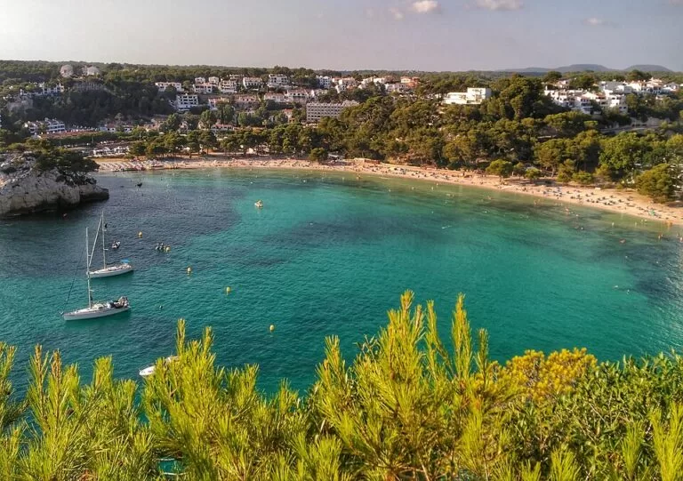
BeachCala Galdana is a shell-shaped bay of golden sand on the south coast of Menorca, in the municipality of Ferreries, about 7–9 km south of Ferreries town on the Me-22 road. The beach is 450 m long and 45 m wide, the water is shallow and usually calm, and a small resort of hotels and apartments wraps around it. It suits families and anyone who wants a full-service beach with parking, buses and food on the sand; skip it if you are looking for an empty, undeveloped cove.
Quick facts
- Names: Cala Galdana, also Cala Santa Galdana; in Spanish sources sometimes Cala Galdana or Santa Galdana. The Catalan Wikipedia says the name comes from the old Arabic name Guad-al Ana.
- Where: south coast of Menorca, Ferreries municipality. The resort of Serpentona, on the far side of the Algendar stream, belongs to Ciutadella.
- Coordinates: 39.9382, 3.9595.
- Size: 450 m long and 45 m wide (spain.info).
- Sand and water: golden sand, shallow, calm water (spain.info).
- Development: semi-urban, with a high occupancy rate in season (spain.info).
- Services listed by spain.info: sunshade and sun lounger hire, water craft hire, toilets, showers, footwash, tourist office, children’s play area, yacht club and a scuba diving area.
- Entry: free; public beach.
Access and parking
By car: the Me-22 (Carretera de Cala Galdana) runs south from Ferreries and ends at the bay; spain.info names the Me-22 as the nearest main road. The Catalan Wikipedia puts the beach seven kilometres from Ferreries; the English Wikipedia, quoting the Rough Guide, gives 9 km. Ferreries sits on the main Maó–Ciutadella road across the middle of the island.
Parking: OpenStreetMap maps several surface car parks tagged as free, about 0.3–0.6 km from the sand, on the east side above the beach and on the west side near the marina. There is also some street-side parking on the road down to the east cliff. In July and August spaces near the sand fill early; we could not find an official count.
By bus: OpenStreetMap shows three TMSA bus lines ending at Cala Galdana: line 51 from Maó, line 52 from Ciutadella and line 53 from Ferreries. The stop “Cala Galdana – Platja” is about 200 m from the beach, with two more at the roundabout at the top of the resort. Timetables are seasonal; check the operator before you travel.
On foot: the Camí de Cavalls coastal path passes through the resort, as a boardwalk on the west side and as Carrer des Canaló on the east side, so you can walk on to Cala Mitjana to the east or towards Macarella to the west.
What to expect
This is a resort beach, not a wild cove. Spain.info describes it as a shell-shaped beach in the Galdana Cove housing estate with shallow water, and rates it semi-urban. The English Wikipedia notes the cove was largely undeveloped until the 1960s; today low and taller hotel and apartment blocks line the slopes above the pines. Expect sun loungers in rows, kiosks and restaurants behind the sand, and boats moored in the bay in summer.
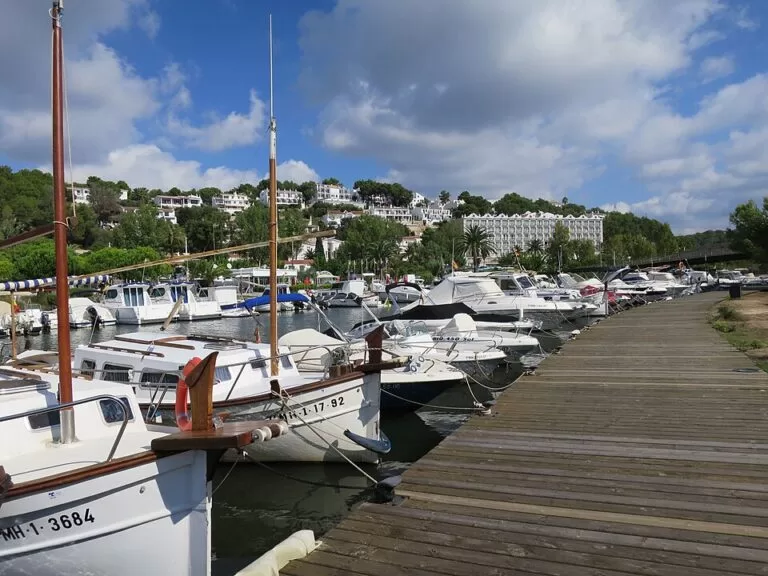
The bay is enclosed by limestone cliffs. Two streams, the Algendar and the Algendaret, reach the sea here (Catalan Wikipedia), and the Algendar gorge (Barranc d’Algendar) runs inland from the west end of the beach. A small marina and a slipway sit at the mouth of the stream, and OpenStreetMap marks a viewpoint, the Mirador de Cala Galdana, on the east headland about 300 m from the beach.
The Catalan Wikipedia, citing Ferreries town hall, says the beach has held an environmental management certificate under ISO 14001 since October 2008.
Practical details
- Food and drink: OpenStreetMap lists about a dozen restaurants, cafés and bars within 500 m of the beach, plus a pharmacy in the resort.
- Toilets and showers: listed by spain.info among the beach services.
- Information: a tourist information point stands near the marina (spain.info lists a tourist office; OpenStreetMap maps the building).
- Water sports: water craft hire and a designated scuba diving area (spain.info).
- Children: shallow water and a playground near the west end of the beach.
- Accommodation: several large hotels and apartment blocks stand directly above the bay; we do not list names because we could not check them against an official source.
Accessibility and safety
A Red Cross (Cruz Roja) post stands just behind the beach on OpenStreetMap, and spain.info’s Ferreries page says the municipality’s equipped beaches have Red Cross cover, sun shades and police. We could not confirm the dates the service runs, so assume it is a summer service. Swimming conditions are normally calm, but the bay is open to the south; follow the flags. We could not confirm step-free access to the sand or an adapted bathing service; the promenade at the back of the beach is level, but the car parks are uphill.
Best time to visit
Spain.info rates occupancy as high. In July and August come before 10:00 for parking and a spot on the sand, or arrive by bus. In June and September the water is still warm and the resort is quieter.
Nearby alternatives
- Cala Mitjana, 1.2 km east: a smaller cove without a resort, reached on foot from the Cala Mitjana car park or along the Camí de Cavalls.
- Cala Macarelleta, 2.1 km west: the small sister cove of Macarella, on foot only.
- Cala Turqueta, 3.8 km west: white sand and pines, reached by road from Ciutadella.
- Naveta des Tudons, 9.2 km north-west: the island’s best-known prehistoric burial chamber, off the Ciutadella road.
- Son Bou, 10.4 km east: Menorca’s longest beach, with dunes and a wetland behind.
Distances are in a straight line from the beach.
FAQ
How do I get to Cala Galdana?
Drive south from Ferreries on the Me-22, which ends at the bay, or take a TMSA bus: line 51 from Maó, 52 from Ciutadella or 53 from Ferreries (lines as mapped on OpenStreetMap; check current timetables).
Is there parking at Cala Galdana?
Yes. Several surface car parks mapped as free lie 0.3–0.6 km from the sand, plus some street-side parking. They fill early in high summer.
Is Cala Galdana good for children?
Yes. The water is shallow and usually calm, there is a playground, and toilets, showers and a Red Cross post are close to the sand.
Can you walk from Cala Galdana to Cala Mitjana and Macarella?
Yes. The Camí de Cavalls coastal path runs through the resort; Cala Mitjana lies 1.2 km east and Macarelleta 2.1 km west in a straight line, and the path is longer and uneven.
How big is Cala Galdana?
Spain.info gives 450 m long and 45 m wide, with golden sand.
Sources and freshness
Checked 9 November 2026 · 6 sources Show
Checked 9 November 2026. Official: spain.info, Cala Galdana (size, sand, services, occupancy, nearest road), spain.info, Ferreries (Red Cross cover, nearby coves) and spain.info, Ciutadella. The Balearic tourism portal www.illesbalears.travel returned server errors on the day we checked. Background: Catalan Wikipedia (streams, municipalities, name, ISO 14001) and English Wikipedia (development since the 1960s, distance). Location, car parks, bus lines and stops, viewpoint, path and distances: OpenStreetMap. Photos: Wikimedia Commons.
This place is part of our Balearic Islands travel guide: Mallorca, Menorca, Ibiza and Formentera — see every town, beach and cove we have mapped on that coast.
How this page is made. CostaMap is written with an AI editorial system run by Ebizapple. This page is based on the sources listed above. Last updated 9 November 2026. Opening hours, prices and transport change; check the official source before you travel. How we work · Partner links and ads