
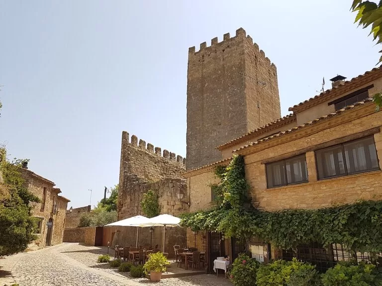
Peratallada is a walled medieval village in the Baix Empordà, inland from the Costa Brava: a castle, a keep, town walls and a moat cut into the sandstone rock, with narrow stone streets inside. It lies 6 km from La Bisbal d’Empordà and about 13 km from the Begur beaches; you drive in, leave the car in a paid car park at the edge, and walk, because the centre is pedestrian. It suits anyone who likes old stone villages, long lunches and photography; skip it if you want a beach day or you dislike crowds on summer afternoons.
Quick facts
- Names: Peratallada (Catalan, the only name in use). It is one of the villages of the municipality of Forallac, together with Fonteta and Vulpellac; Forallac was formed in 1977 and its name is an acrostic of the three.
- Where: centre of the Baix Empordà, Girona province. About 6 km from La Bisbal d’Empordà, 4.6 km in a straight line from Pals and 14 km from Begur.
- Coordinates: 41.9778, 3.0899.
- Population: 195 (catalunya.com); altitude 37 m.
- Main sights: the castle and keep (11th–12th century), the walls (12th–13th century), the rock-cut moat, the arcaded Plaça de les Voltes, Plaça del Castell and the Romanesque church of Sant Esteve.
- Tourist office: Plaça del Castell 3, a few metres from the castle; tel. 872 987 030 (catalunya.com).
- Entry to the village: free. Parking at the entrance is paid.
Access and parking
By car: Peratallada sits on the GI-651, with road links to La Bisbal d’Empordà, Pals and Torroella de Montgrí. The Catalan tourist board says the centre is pedestrian and that you reach it by car using the park-and-ride car parks at the entrance (catalunya.com).
Parking: OpenStreetMap maps several surface car parks, all marked as paid: two on the north-west side, about 100–125 m from the walls, one beside the bus stops on the GI-651, and a larger one on the south-east side, about 250 m from the centre, run by the Forallac town hall, with ticket machines and free public toilets next to it. We could not confirm the current tariffs.
By bus: OpenStreetMap shows two stops on the main road just north of the old town, one towards La Bisbal and one towards Palafrugell. The tourist board notes buses to La Bisbal d’Empordà; check timetables before you rely on them, especially out of season.
What to expect
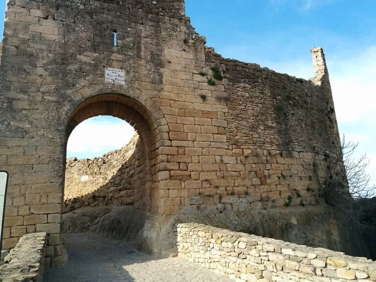
The tourist board calls Peratallada a historical and artistic ensemble of medieval origin: a castle-palace, walls and a village of narrow streets and stone houses, all set on sandstone rock that was dug out to make the dungeon and the moat. The village is documented from the 11th century, though it may have been inhabited in Roman times.
The castle is the core. It is formed by a fortified nucleus with a keep, plus the palace and the walls. It dates from the 11th and 12th centuries, with later changes. The walls are from the 12th–13th centuries, with the upper part rebuilt between the 16th and 18th centuries. The castle belonged to the Cruïlles-Peratallada family: Berenguer de Cruïlles (1310–1362), bishop of Girona and first president of the Generalitat de Catalunya, was born here. Today it belongs to the counts of Torroella de Montgrí, who restored it in the mid-20th century. We could not confirm whether any part of the castle interior is open to visitors.
Two squares anchor a walk: the arcaded Plaça de les Voltes and the Plaça del Castell, in front of the castle and palace. Outside the walls stands the parish church of Sant Esteve, Romanesque, with two naves, semicircular apses, a round-arched portal and a bell gable with four openings; inside is a Gothic tomb from 1348. A small viewpoint, the Torre de les Hores, is mapped on OpenStreetMap at the western edge of the old centre.
Food is a large part of the visit. The tourist board says the village relies on tourism, with hotels, rural houses, craft shops and many restaurants. OpenStreetMap lists more than a dozen restaurants inside or just outside the walls, many of them around the two squares. The board also points out a handmade ice-cream maker, Gelat Artesà de Peratallada, known for unusual flavours such as Roquefort and L’Escala anchovy.
Practical details
- Tourist office: in a stone house on Plaça del Castell, sharing the space with the village social bar. Staff speak Catalan, Spanish, English and French, and you can pick up leaflets on walks in the old centre and on foot and bike routes nearby (catalunya.com). We could not confirm current opening hours.
- Toilets: OpenStreetMap shows free public toilets by the north-west car park and by the south-east car park, both marked wheelchair-accessible, plus one on Plaça del Castell.
- Drinking water: several public water taps are mapped in and around the village.
- Events: the Herb Fair (Fira de les Herbes) at the end of April; the Festa Major around 6 August, for Sant Esteve; and the Medieval Fair on the first weekend of October, with artisan stalls, jugglers, storytelling and knights’ tournaments. Expect the village to be very full during the Medieval Fair.
Accessibility and safety
The streets are stone and partly cobbled; OpenStreetMap tags some of them as rough, unhewn cobblestone, while Plaça del Castell is paved. Expect uneven ground, slopes and some steps; wheelchair users may find parts of the village hard going. The tourist office and the car-park toilets are tagged wheelchair-accessible. There is no traffic inside the old centre, but watch for cars on the GI-651 when crossing from the bus stops and car parks.
Best time to visit
The Catalan tourist board says any season works, as winters are mild and summers are not too harsh. For a quieter walk, come in the morning or on a weekday outside July and August. If you like crowds and street theatre, aim for the Medieval Fair on the first weekend of October; for something smaller, the Herb Fair at the end of April.
Nearby alternatives
- Pals old town, 4.6 km away: a walled hilltop quarter with the Torre de les Hores and a viewpoint over the Empordà plain.
- Iberian Town of Ullastret, 3.2 km away: one of the most important Iberian sites in Catalonia.
- Cork Museum of Palafrugell, 9 km away: the local cork industry, in Palafrugell.
- Begur, 10 km away: a historic centre close to some of the best-known Costa Brava coves.
- Platja d’Aiguablava, 11.5 km away: one of the Begur beaches, for a swim after the village.
Distances are in a straight line from Peratallada.
FAQ
Is there parking in Peratallada?
Yes. Cars stay outside the pedestrian centre in paid car parks at the edge of the village, on the north-west side about 100 m from the walls and on the south-east side about 250 m away.
How do I get to Peratallada without a car?
There are bus stops on the main road just outside the old town, with buses towards La Bisbal d’Empordà and Palafrugell. Check timetables before you travel.
Can you visit Peratallada castle?
The castle is privately owned by the counts of Torroella de Montgrí, according to the Catalan tourist board. You can see the keep, walls and moat from the streets and squares; we could not confirm interior visits.
When is the Peratallada Medieval Fair?
On the first weekend of October, according to the Catalan tourist board. There is also a Herb Fair at the end of April.
How long do you need in Peratallada?
The walled village is small: one to two hours covers the squares, the walls, the moat and the church of Sant Esteve, longer if you stay for lunch.
Sources and freshness
Checked 6 November 2026 · 5 sources Show
Checked 6 November 2026. Official: Catalan Tourist Board pages on Peratallada (history, castle, walls, squares, church, access, events, population), Forallac (municipality, buses, Medieval Fair date), the Peratallada tourist office (address, phone, languages) and the Medieval Fair. The Forallac town hall website could not be reached from our tools. Location, car parks, toilets, water taps, bus stops, street surfaces and distances: OpenStreetMap contributors (ODbL). Photos: Wikimedia Commons, licences as credited.
How this page is made. CostaMap is written with an AI editorial system run by Ebizapple. This page is based on the sources listed above. Last updated 6 November 2026. Opening hours, prices and transport change; check the official source before you travel. How we work · Partner links and ads