
Prat de Cabanes-Torreblanca Natural Park
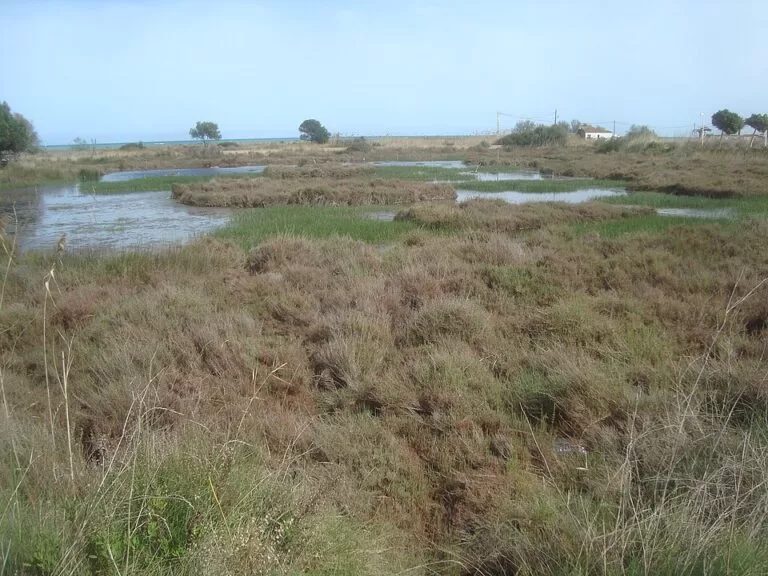
Natural parkThe Prat de Cabanes-Torreblanca Natural Park is a coastal wetland on the Costa del Azahar, a narrow strip of marsh behind a pebble beach between Torreblanca and Oropesa del Mar in Castellón. You reach it from the N-340 by the turn-off for the Ribera de Cabanes, or from the AP-7 at Oropesa, and walk in from two ends: Torre de la Sal in the south and Torrenostra in the north, each with free parking. It is a place for birdwatching and flat, easy walks with the sea always close. It suits walkers and birdwatchers. Skip it if you want a resort beach or shade in July.
Quick facts
- Names: Prat de Cabanes-Torreblanca in Valencian (Parc Natural del Prat de Cabanes-Torreblanca); Prado de Cabanes-Torreblanca in Spanish. Locals simply say “el Prat”.
- Where: on the coast of the municipalities of Cabanes and Torreblanca, comarca of La Plana Alta, province of Castellón, between Oropesa del Mar and Torrenostra.
- Coordinates: 40.1686, 0.1813 (centre of the reserve on OpenStreetMap). Southern entrance at Torre de la Sal: 40.1304, 0.1625. Northern entrance at Torrenostra: 40.1974, 0.2217.
- Size: 865 hectares, about 7 km long and 1.5 km wide (Spanish Wikipedia).
- Entry: free; there is no ticket and no booking for the marked routes.
- Park office: Ribera de Cabanes, next to the Instituto de Acuicultura de Torre de la Sal; phone 964 376 410, email parque_prat@gva.es (Turisme Comunitat Valenciana).
Access and parking
By car: Spanish Wikipedia gives two approaches: from the N-340 by the turn-off for the Ribera de Cabanes, or from the AP-7 at the Oropesa del Mar exit.
Torre de la Sal (south): OpenStreetMap shows a free surface car park at the start of the coastal path, with a map board and signposts beside it, and a second free car park about 600 m north, close to a bird hide. This is the start of the Red Route.
Torrenostra (north): the seaside district of Torreblanca has free car parks near the beach (OpenStreetMap) and the Tourist Info Torreblanca Platja office (phone +34 964 425 184). The Yellow Route starts here.
Without a car: the Valencia–Tarragona railway runs along the inland edge of the marsh, but the sources we opened do not list a station at the park itself. Torreblanca and Oropesa del Mar both have stations; check Renfe for current services and plan a taxi or a bike for the last few kilometres.
What to expect
The regional tourist board calls the Prat “one of the most unspoilt wetlands in the Region of Valencia”, a narrow strip of marshland that flanks the coast between Torreblanca and Oropesa del Mar, framed inland by the Serra d’Irta and the Serra de les Santes (Turisme Comunitat Valenciana). It is flat country: reed beds, salt marsh, channels and pools behind a pebble ridge.
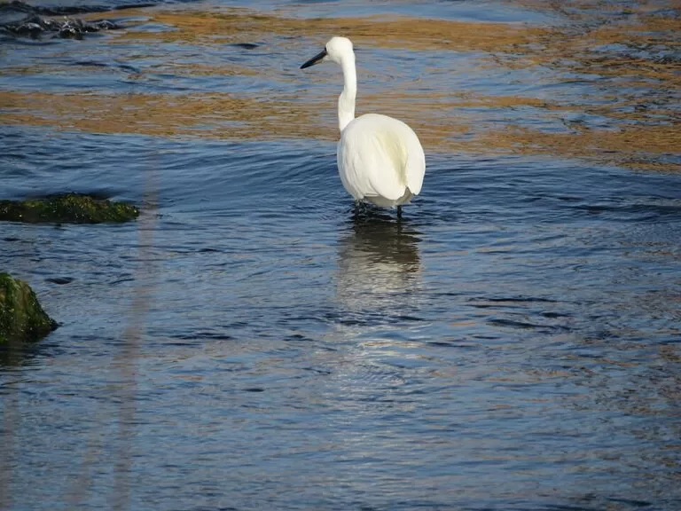
The park is known for three small endemic animals: the Valencia toothcarp (samaruc), the Spanish toothcarp (fartet) and the peacock mantis shrimp (gambeta). Birdwatchers come for the migrants that pass over in spring and autumn. Spanish Wikipedia lists breeding collared pratincole, Montagu’s harrier, black-winged stilt and little bittern, and says the park holds the only breeding site of the little tern in the province of Castellón. Wintering birds include cormorant, marsh harrier and kingfisher.
The Cabanes town page on the regional portal describes three marked routes (Turisme Comunitat Valenciana):
- Red Route – Torre de la Sal: an easy 3.5 km walk along the coast, where pebble banks give way to a micro-reserve of Phoenician juniper and the channels of the marsh.
- Blue Route – Cuartel de Carabineros: an almost entirely flat 8 km trail along the shore, over pebble ridges and fossil dunes, to the ruins of the old Carabineros barracks, then back inland through wetland, channels and marsh.
- Yellow Route – Torrenostra: a flat 4.5 km route into the wetland past lagoons that are good for birdwatching, farmland and the Gola del Trenc viewpoint, returning to the coast through salt-marsh vegetation.
The Gola del Trenc viewpoint is a wooden observation tower, free and open, about 1.5 km south-west of Torrenostra (OpenStreetMap). OpenStreetMap also marks bird hides near Torre de la Sal and on the edge of Torrenostra, and an archaeological site, the Jaciment del Prat, with storage pits that its description dates to about 5,000 years ago.
Beaches and towers
The marsh ends at the sea in long natural beaches of pebbles and sand. Torre de la Sal beach, at the southern end, has calm water and traditional fishermen’s houses by the shore. Quartell Vell, inside the park, is a naturist beach with the remains of the old barracks behind it. Along the coast stand the medieval Torre de la Sal and the Carmelet, del Carmen and dels Gats towers, from the 15th and 16th centuries (Turisme Comunitat Valenciana, Cabanes). At the northern end, Torreblanca’s El Prat beach leads from Torrenostra into the park.
Practical details
- Water and toilets: OpenStreetMap shows a public toilet (wheelchair accessible) and drinking water by the beach in Torrenostra. We found none marked inside the park, so bring water.
- Shade: very little. The routes cross open marsh and pebble beach.
- Information: the regional portal lists tourist info points in Torreblanca, Torreblanca Playa, Cabanes and Cabanes–Torre la Sal as information points for the park.
Accessibility and safety
The routes are flat, but the surfaces are dirt tracks, pebble ridges and earth paths; the sources we opened do not describe any route as adapted for wheelchairs. Stay on the marked paths: the park protects endangered fish and nesting birds. The beaches inside the park are natural beaches; we could not confirm lifeguard cover, so swim with care.
Best time to visit
Spring and autumn are best for migrating birds and for walking in mild weather. Winter brings the wintering birds and quiet paths. In July and August go early: there is almost no shade.
Nearby alternatives
- Torreblanca town guide, 4.7 km from the centre of the park to Torrenostra: the town, its beaches and the Torre Nostra tower.
- Oropesa del Mar, 9.3 km away: beaches on both sides of the cape and the start of the Vía Verde del Mar.
- Alcossebre, 11 km away: beaches and coves at the southern edge of the Serra d’Irta.
- Arch of Cabanes, 14.2 km away: the Roman arch beside the old Via Augusta, inland in the same municipality.
- Vía Verde del Mar, 14.7 km away: a paved coastal greenway between Benicàssim and Oropesa.
- Desert de les Palmes Natural Park, 15.2 km away: the mountain park behind Benicàssim, with longer hikes.
Distances are in a straight line from the centre of the park.
FAQ
How do I get to the Prat de Cabanes-Torreblanca?
By car, take the N-340 turn-off for the Ribera de Cabanes or the AP-7 exit for Oropesa del Mar and follow the road to Torre de la Sal. From the north, start in Torrenostra, the beach district of Torreblanca.
Is there parking at the Prat de Cabanes-Torreblanca?
Yes, free car parks at Torre de la Sal (south) and Torrenostra (north), per OpenStreetMap.
Which walking routes are there in the Prat de Cabanes?
Three marked routes: the Red Route from Torre de la Sal (3.5 km, easy), the Blue Route to the Carabineros barracks (8 km, almost flat) and the Yellow Route from Torrenostra (4.5 km, flat).
Can you swim at the Prat de Cabanes?
Yes, from the natural beaches along its shore, such as Torre de la Sal beach and Quartell Vell, which is a naturist beach. They are pebble and sand beaches without resort services.
Sources and freshness
Checked 7 November 2026 · 5 sources Show
Checked 7 November 2026. Official: Turisme Comunitat Valenciana, Prat de Cabanes-Torreblanca (description, endemic species, park office contact, information points), Cabanes (the three routes, beaches and watchtowers) and Torreblanca (Torrenostra and El Prat beach). The park’s own pages on parquesnaturales.gva.es and the town hall websites of Cabanes and Torreblanca could not be reached from our checker. Background (area, length, access roads, birds): Spanish Wikipedia. Location, car parks, hides, viewpoint and toilets: OpenStreetMap contributors (ODbL). Photos: Wikimedia Commons, licences as credited.
This place is part of our Costa del Azahar travel guide: map, beaches, camping and the Castellón coast — see every town, beach and cove we have mapped on that coast.
How this page is made. CostaMap is written with an AI editorial system run by Ebizapple. This page is based on the sources listed above. Last updated 6 November 2026. Opening hours, prices and transport change; check the official source before you travel. How we work · Partner links and ads