
Villaricos (Cuevas del Almanzora)
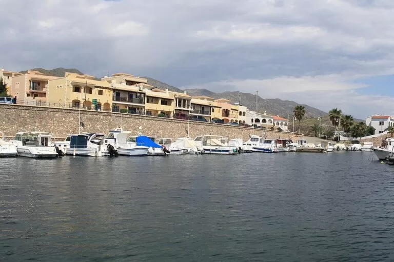
VillageVillaricos is a small fishing and holiday village at the mouth of the Almanzora river, on the Levante coast of Almería, part of the municipality of Cuevas del Almanzora. It stands on the site of Baria, a Phoenician town whose rock-cut tombs are now a protected archaeological zone, and has an 18th-century coastal tower, two small ports and short beaches of dark sand and gravel. By car it is about 12 km from Vera on the AL-7107 coast road. It suits people who want a quiet base with history and diving; skip it if you want a long resort beach with a busy promenade.
Quick facts
- Name: Villaricos; the ancient town was Baria (Barea in Roman times).
- Municipality: Cuevas del Almanzora, Levante Almeriense, Almería province.
- Coordinates: 37.2486, -1.7714 (OpenStreetMap).
- Population: 670 in 2019 (INE, via Spanish Wikipedia).
- Road distances: Vera 12 km, Cuevas del Almanzora 14 km, Almería 95 km (Spanish Wikipedia).
- Archaeological zone: 301,638 m², listed as a Bien de Interés Cultural in 2005 (Andalucía.org).
- Ports: the old port of Villaricos and the Puerto Deportivo de Villaricos La Esperanza; Andalucía.org links the latter to the Andalusian ports agency (EPPA).
- Beaches: Playazo de Villaricos (Blue Flag in 2019), the coves of Villaricos, Quitapellejos and Pozo del Esparto.
Access and parking
By car: Villaricos lies on the AL-7107, the road that follows the coast from Las Marinas in Vera north to San Juan de los Terreros; the AL-8106 links it with Las Herrerías inland (Spanish Wikipedia). From the A-7 motorway leave at Vera or Cuevas del Almanzora. In a straight line Garrucha is about 8 km south, Mojácar 14 km and San Juan de los Terreros 16 km north.
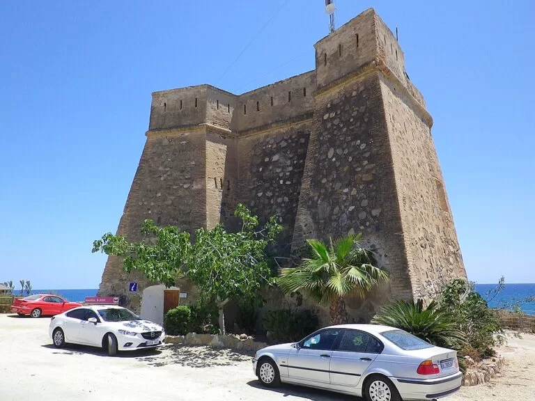
Parking: Andalucía.org lists parking at the Playazo de Villaricos, at the entrance to the village next to the castle. We could not confirm the number of spaces or whether parking is free in summer.
Without a car: we could not confirm current bus services to Villaricos; check with the Cuevas del Almanzora tourist office before you rely on public transport.
What to expect
Baria: the Phoenician town at Villaricos is one of the key sites for the study of Phoenician settlement in Iberia. The Junta de Andalucía dates its foundation to the 8th century BC; the site goes back to the Copper Age and was lived in until the early Middle Ages. The only visible remains of the Phoenician and Punic town are in the necropolis north of the village, with monumental tombs cut into the rock from the 7th century BC. Mine works from the mid-19th century, for lead and iron, share the same ground (Andalucía.org). The archaeologist Luis Siret excavated the necropolis between 1890 and 1910, and his collection is now in the National Archaeological Museum in Madrid; finds from Baria are also in the Museum of Almería (Spanish Wikipedia). Much of the old town lies under the modern village, so expect a site to read about rather than ruins to walk through.
The castle: the Castillo de Villaricos, also called the Torre de Cristal, is an 18th-century tower built, like its sisters at Macenas and Mesa Roldán, to watch for Barbary pirates. It now holds a tourist information point and a small room for temporary exhibitions, and is the starting point for learning about Baria (Andalucía.org).
Beaches: the Playazo de Villaricos, at the entrance to the village beside the castle, has dark sand and rocks from old smelting slag, a sign of the mining past. Andalucía.org lists lifeguards, shade, adapted toilets, amphibious chairs with staff, and easy access for people with reduced mobility. Spain.info groups the small beaches in the village as the Playa de Villaricos: 550 m of gravel with calm water, made up of Cala de la Esperanza, Cala Verde and Cala de la Luz Eléctrica, ending in the south at the mouth of the Almanzora. North of the village, Quitapellejos is 1,400 m of sand and gravel with few buildings, and Pozo del Esparto is a long, narrow 1,200 m beach in front of the village of the same name (spain.info).
Diving and boats: Andalucía.org lists two diving schools in Villaricos, alongside the two ports.
Practical details
- Tourist information: Punto de Información at the Castillo de Villaricos, on the Garrucha–Águilas road; the Cuevas del Almanzora tourist office is in the Castillo del Marqués de los Vélez in the town.
- Health: a medical consulting room on the Paseo Marítimo (Spanish Wikipedia).
- Marina: Puerto Deportivo de Villaricos La Esperanza, Calle Esperanza (Andalucía.org).
- Opening hours of the castle information point could not be confirmed; check before you go.
Accessibility and safety
The Playazo de Villaricos is the accessible choice, with amphibious chairs and support staff in the bathing season. The cove beaches are gravel. The necropolis is an archaeological zone; do not climb on the tombs. Palomares, the next village south, is known for the 1966 accident in which three American bombs fell on its beaches (Andalucía.org).
Best time to visit
June to September for swimming, when lifeguards work on the Playazo. Spring and autumn are better for walking around the necropolis and the Sierra Almagrera without the heat. From 2013 to 2023 the Dreambeach electronic music festival was held here in August (Spanish Wikipedia).
Nearby alternatives
- Mojácar la Vieja, 13 km: the hill where Mojácar stood until the mid-13th century.
- Mojácar, 14 km: the white hill village and its 17 km of beaches.
- San Juan de los Terreros, 16 km: the last beaches of Andalusia, with a castle and two islets.
- Geoda de Pulpí, 16 km: the giant gypsum geode in an old mine.
- Cuatro Calas walk (Águilas), 20 km: coves just over the Murcia border.
Distances are in a straight line from Villaricos. Our town guides cover Cuevas del Almanzora, Vera and Garrucha.
FAQ
Where is Villaricos?
On the coast of north-east Almería, at the mouth of the Almanzora river, in the municipality of Cuevas del Almanzora. It is about 12 km by road from Vera.
What was Baria?
A Phoenician town founded at Villaricos, which the Junta de Andalucía dates to the 8th century BC. It later became a Roman town. Its rock-cut tombs are the visible part of the archaeological zone.
Is there a beach in Villaricos?
Yes. The Playazo de Villaricos has dark sand and lifeguards in season, and the coves in the village add 550 m of gravel beach with calm water.
Can you dive at Villaricos?
Yes. Andalucía.org lists two diving schools in the village.
Is there parking in Villaricos?
Andalucía.org lists parking at the Playazo, at the entrance to the village. We could not confirm the number of spaces or fees.
Sources and freshness
Checked 9 November 2026 · 10 sources Show
Checked 9 November 2026. Official: Andalucía.org (Junta de Andalucía tourism) on the archaeological zone, the Castillo de Villaricos, the Playazo de Villaricos, the La Esperanza marina and Cuevas del Almanzora; spain.info (Turespaña) beach sheets for Villaricos, Quitapellejos and Pozo del Esparto. Background on population, roads, distances, Luis Siret and Dreambeach: Spanish Wikipedia. Location and straight-line distances: OpenStreetMap contributors (ODbL). Not confirmed: bus services, parking fees, opening hours of the castle and visits to the necropolis (the Cuevas del Almanzora and Junta de Andalucía culture sites could not be reached). Photos: Wikimedia Commons, licences as credited.
This place is part of our Costa de Almería travel guide: where it is, Cabo de Gata, Mojácar and Almería city — see every town, beach and cove we have mapped on that coast.
How this page is made. CostaMap is written with an AI editorial system run by Ebizapple. This page is based on the sources listed above. Last updated 9 November 2026. Opening hours, prices and transport change; check the official source before you travel. How we work · Partner links and ads