
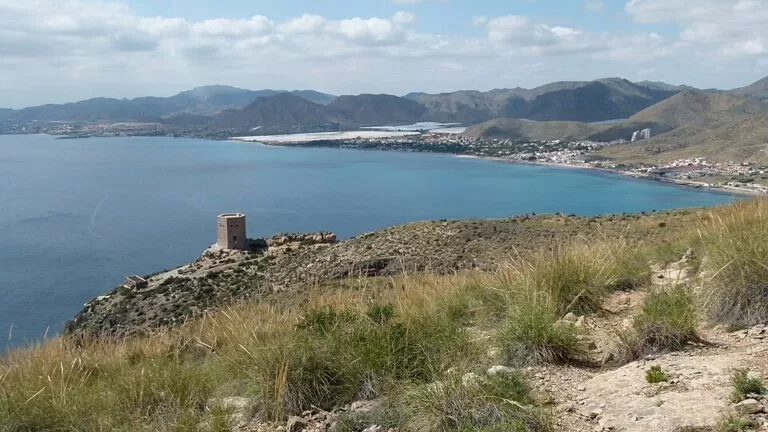
La Azohía is a small fishing village in the far west of Cartagena municipality, at the foot of Cabo Tiñoso, on the RM-E22 road from Cartagena towards Mazarrón. It has an 800 m sand-and-gravel town beach, a 16th-century watchtower on the point, a working tuna-trap fishery and some of the best diving on the Costa Cálida; Isla Plana, 3.6 km west, is its larger beach neighbour. It suits divers, walkers and families who want a quiet village beach; skip it if you want nightlife, big hotels or a long walk on fine sand.
Quick facts
- Names: La Azohía (Spanish). The name comes from the Arabic zāwiya, “the corner” or “the hermitage”. The town beach is listed as Playa de la Azohía – El Cuartel.
- Where: the Perín district of Cartagena, Region of Murcia, on the east side of the Bay of Mazarrón, sheltered by Cabo Tiñoso.
- Coordinates: 37.5530, -1.1700 (the harbour and town beach).
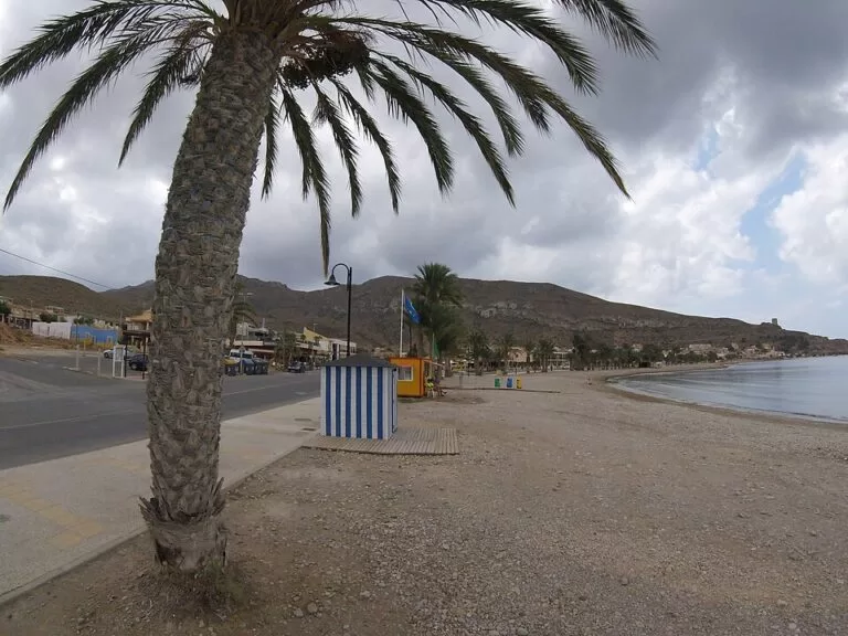
- Beach: 800 m long, average width 8 m, medium sand and gravel (regional tourist board).
- Watchtower: the Torre de Santa Elena, a 16th-century polygonal defence tower on the Punta de la Azohía.
- Protection: the beach lies in a marine protected area; the mountains behind belong to the Sierra de la Muela, Cabo Tiñoso y Roldán natural area (7,776 ha).
- Feel: no real centre: houses are spread for about 3 km along the coast road down to the fishing port.
Access and parking
By car: from Cartagena follow the RM-E22 towards Mazarrón and turn off for Isla Plana and La Azohía (Region of Murcia tourism, La Azohía beach). The village road runs along the shore to the harbour. Cartagena’s old town is about 17 km away in a straight line.
Parking: the tourist board lists parking “in the village”, with three spaces reserved for people with reduced mobility by the beach. OpenStreetMap shows a small free car park on the Plaza de Juan Paredes by the harbour (six spaces), a few more small car parks near the port and two larger dirt car parks at the north end of the village, about 1.2 km from the harbour.
By bus: the ALSA Cartagena–Mazarrón line stops in La Azohía; OpenStreetMap shows stops at the Estanco, at the Restaurante La Bodega and at the harbour. Check timetables with ALSA before you travel.
What to expect
The regional tourist board describes Isla Plana and La Azohía as small villages with large sandy beaches and mountain views that have long been traditional summer resorts (Cartagena coast and La Unión). La Azohía is the quieter of the two. The town beach runs along the village in front of the houses, with a few restaurants and a small fishing harbour at the south end. OpenStreetMap names Playa de la Chapineta and Playa de San Ginés along the same shore to the north.
The village is known for the almadraba, the trap net for tuna. The tourist board calls it an age-old art practised by the Arabs, and the trap is still set off the coast; a fish shop by the harbour sells the catch. On the point south of the harbour stands the Torre de Santa Elena, built in the 16th century to warn the coast of Barbary pirate raids. It is a listed monument; the tower is reached on foot from the end of the promenade, about 500 m from the harbour.
Past the point the coast turns to cliff. The tourist board names Cala Cerrada and Cala Abierta, quiet coves reached by boat or by walking down paths, and Cabo Tiñoso, a lookout over 300 m high. Divers come for the Cabo Tiñoso marine reserve: the tourist board lists dive sites from 3 m down to 54 m, including caves with inner air lagoons, wrecks used by the Navy diving centre and walls such as the 500 m Pared del Capitán (diving Cartagena – La Azohía – Cabo Tiñoso).
Practical details
- Beach services (2026): toilets and an adapted toilet, an adapted changing room, litter bins, restaurants, a 6 × 6 m adapted shaded area, two amphibious chairs and a pair of amphibious crutches, and an assisted-bathing service with lifejackets (tourist board).
- Tourist information: the Isla Plana tourist information point covers both villages.
- Isla Plana: its beach is 580 m long and about 12 m wide, with beach bars, footbaths, first aid and lifeguards; assisted bathing runs from 1 July to 31 August, 11:30–20:00 (tourist board, checked November 2026).
- Batería de Castillitos: the coastal gun battery on Cabo Tiñoso, built in 1933–36 with a castle-like façade, is about 4.6 km south-east in a straight line. Access is from the RM-E23 road towards Campillo de Adentro and the Cabo Tiñoso lighthouse, then about 800 m uphill on foot on a dirt track from the car park (Wikipedia; we could not confirm access rules on an official site).
- Shops: OpenStreetMap shows a fish shop and restaurants in La Azohía; Isla Plana has a supermarket and a pharmacy.
Accessibility and safety
The tourist board rates La Azohía beach “practicable, equipped” for people with reduced mobility: no ramp is needed, a 2 m wooden walkway crosses the sand, and the adapted toilet joins the walkway without a step. Staff lend the amphibious chair and help with bathing. The sand is mixed with gravel. The coves beyond the point have no services, and the cliff paths are steep: take water, shoes with grip and a phone, and do not go down in high wind.
Best time to visit
June and September suit a beach stay: the water is warm and the tourist board’s “high” occupancy applies mostly to July and August. Spring and autumn are better for walking up to Cabo Tiñoso and the batteries, when the heat is lower. Diving is possible all year with a wetsuit; the tourist board stresses that Cartagena’s seabed is protected from the east wind.
Nearby alternatives
- El Portús beach, 9.2 km away: a pebble beach in a fishing village on the other side of Cabo Tiñoso, popular with divers.
- Puerto de Mazarrón, 7.9 km away across the bay: the harbour town with longer sandy beaches.
- Phoenician shipwrecks of Mazarrón, 8.5 km away: the site off Playa de la Isla where two Phoenician boats were found.
- Gredas de Bolnuevo, 12.7 km away: wind-carved sandstone formations above the beach at Bolnuevo.
- Roman Theatre of Cartagena, 17.2 km away: the theatre museum in Cartagena’s old town.
Distances are in a straight line from the harbour of La Azohía.
FAQ
Where is La Azohía?
On the coast west of Cartagena, at the foot of Cabo Tiñoso on the east side of the Bay of Mazarrón. It belongs to Cartagena municipality and is reached by the RM-E22 road from Cartagena towards Mazarrón.
Is there parking in La Azohía?
Yes, but it is limited. There is a small free car park by the harbour, a few small car parks near the port and larger dirt car parks at the north end of the village. Three reserved spaces for people with reduced mobility are by the beach.
Can you get to La Azohía by bus?
Yes. The ALSA bus between Cartagena and Mazarrón stops in the village, including at the harbour.
Is La Azohía good for diving?
Yes. It is the base for the Cabo Tiñoso marine reserve, where the regional tourist board lists caves, walls, wrecks and ridges from 3 m to 54 m deep, for beginners and experienced divers.
Is the beach at La Azohía sandy?
It is medium sand mixed with gravel, 800 m long and narrow, about 8 m on average. Isla Plana’s beach next door is similar.
Sources and freshness
Checked 7 November 2026 · 9 sources Show
Checked 7 November 2026. Official: Region of Murcia tourist board on La Azohía – El Cuartel beach (size, services, bus, 2026 accessibility data; Spanish version), Isla Plana beach, the Cartagena coast (tower, almadraba, coves, Cabo Tiñoso), diving La Azohía – Cabo Tiñoso and the Sierra de la Muela natural area. Background: Wikipedia on La Azohía (name, layout) and Batería de Castillitos. Location, car parks, bus stops, shops and distances: OpenStreetMap contributors (ODbL). Photos: Wikimedia Commons, licences as credited.
How this page is made. CostaMap is written with an AI editorial system run by Ebizapple. This page is based on the sources listed above. Last updated 9 November 2026. Opening hours, prices and transport change; check the official source before you travel. How we work · Partner links and ads