
Ermita de la Misericòrdia (Vinaròs)
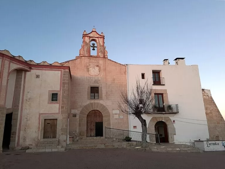
Historic siteThe Ermita de la Misericòrdia is the hilltop sanctuary of Vinaròs, on the Puig de la Misericòrdia about 6 km from the town centre, with a 15th-century origin, an 18th-century nave and tiled murals inside (Comunitat Valenciana). Around it on the same hill are the Torre dels Moros, an Iberian settlement and three olive trees the tourist board calls millennial, with car parks and a picnic area by the church. It suits anyone who likes a short drive, a view of the coast and some history; skip it if you only want the beach.
Quick facts
- Names: Ermita de la Mare de Déu de la Misericòrdia (Valencian), Ermita or Santuario de Nuestra Señora de la Misericordia (Spanish), Shrine of Our Lady of Mercy. The tourist board gives the address as Colina de El Puig.
- Where: Camí de Sant Sebastià / Camí de l’Ermita, on the hill north-west of Vinaròs (Castellón).
- Coordinates: 40.5069, 0.4315 (the church).
- Built: a chapel is documented here in the 15th century; the present building comes from changes in the 16th and 17th centuries, a new nave of 1722 and a high altar of 1733.
- Also on the hill: the Torre dels Moros (Torre de los Moros), a protected monument (Bien de Interés Cultural) since 1985; the Iberian settlement of the Puig; protected trees.
- Contact: Vinaròs tourism, tel. 964 455 253, turisme@vinaros.es (tourist board listing).
- Entry: the grounds are open ground; we could not confirm church opening hours.
Access and parking
By car: the sanctuary is about 5.5 km in a straight line north-west of the centre of Vinaròs, and about 6 km by the tourist board’s measure. On OpenStreetMap the lanes up the hill pass the Urbanització La Closa; the church stands on the Camí de Sant Sebastià, with the Camí de l’Ermita below it.
Parking: OpenStreetMap shows two car parks right next to the church and a picnic site beside it.
On foot: the hill is part of the Serra del Puig, one of the landscapes the tourist board recommends for family walks and bike routes around Vinaròs (Comunitat Valenciana). Vinaròs railway station is 4.4 km away in a straight line. We could not confirm a bus to the hill.
What to see
The sanctuary
A chapel stood here in the 15th century. The building you see is the result of many changes in the 16th and 17th centuries. In 1722 a new nave was built, paid for by the town’s fishermen and farm workers, who funded the altarpieces of San Sebastián and San Antonio respectively. In 1733 the high altar was commissioned from the Vergara family of artists to hold the statue of the Virgen de la Misericordia. The church is neoclassical, on a Latin-cross plan, with a barrel-vaulted nave with lunettes, side chapels, a dome over the crossing and a straight-ended presbytery. Inside are 18th-century ceramic murals, thought to come from L’Alcora, and a mosaic floor (Comunitat Valenciana).
The Torre dels Moros
Just below the church, on the side of the hill, stands the Torre dels Moros, a watchtower with views over the plain and the coast. Iberian settlements occupied the spot as early as the 7th to 6th centuries BC. In the Islamic period a small rural population lived here and the rectangular tower, six metres wide, with a cistern, several floors and loopholes, became its stronghold. It was used and altered again in the 16th and 17th centuries, which shows in the walls (Comunitat Valenciana). OpenStreetMap records it as a Bien de Interés Cultural inscribed in 1985.
The Iberian settlement
The excavated settlement on the Puig had three phases: one in the Iron Age and two in the Iberian period. Of the Iron Age there are rectangular masonry buildings in poor condition. The Iberian part has a wall more than four metres thick in places, and the finds include amphorae, pots and tripod plates. The settlement was abandoned in the 5th century BC, reoccupied as a small farm with a strategic role among neighbouring sites such as Puig de la Nau and El Perengil, and finally abandoned at the end of the 2nd century BC (Comunitat Valenciana). A viewpoint marked “Poblado Ibero” on OpenStreetMap stands above the remains, about 250 m south of the church.
The old trees
The grounds of the sanctuary hold three olive trees that the tourist board calls millennial, set among pines, scrub and dry-stone walls; it notes that each metre of trunk girth stands for about 200 years of growth, and that guided tours of the trees are run (Comunitat Valenciana). OpenStreetMap lists several protected trees by the church, including an olive with a girth of 4.83 m, an elm 11 m tall and a bellaombra (ombú) tree.
Practical details
- Allow one to two hours for the church, the tower, the viewpoint over the Iberian site and the trees.
- Bring water and a picnic: there is a picnic site by the church. We found no listed café or shop on the hill.
- Wear shoes with grip for the paths down to the tower and the Iberian site.
- For church opening times or a guided visit, contact Vinaròs tourism (964 455 253) or Vinaròs Tourist Info, Passeig Blasco Ibáñez 1, open Monday to Saturday 9:30–16:00 and Sundays and holidays 11:00–14:00, checked November 2026 (Comunitat Valenciana).
Accessibility and safety
The car parks are next to the church. The Iberian site and the tower are reached by paths on the slope, which are uneven, and we could not confirm step-free access to them or into the church. In summer there is little shade on the paths away from the trees; carry water. Do not climb on the walls of the tower or the excavated remains.
Best time to visit
Spring, autumn and winter afternoons are the most pleasant for the walk round the hill; in summer go early in the morning or near sunset. Clear days give the widest view over the plain and the coast. If you want the church open, ask the tourist office first.
Nearby alternatives
- Vinaròs town guide, 5.5 km away: the old town, the church-fortress of the Assumption, the port and the king prawns.
- Puig de la Nau, 4.0 km away: the Iberian town on the hill north of Benicarló, visited with a guide booked through the Benicarló museum.
- Cala de la Foradada, 6.3 km away: the snorkelling cove with the pierced rock on the Vinaròs north coast.
- Alcanar and Les Cases d’Alcanar, 7.2 km away: the first town over the Catalan border.
- Peñíscola Castle, 16.6 km away: the Templar castle of Pope Luna on its rock.
- Morella, about 47 km inland: the walled capital of Els Ports.
Distances are in a straight line from the church. More on the area in the Vinaròs and Benicarló guide.
FAQ
Where is the Ermita de la Misericòrdia in Vinaròs?
On the Puig de la Misericòrdia, a hill about 6 km from the centre of Vinaròs, reached by the Camí de Sant Sebastià. Coordinates: 40.5069, 0.4315.
Is there parking at the Ermita de la Misericòrdia?
Yes. OpenStreetMap shows two car parks next to the church, with a picnic site beside them.
What is the Torre dels Moros?
A rectangular watchtower, six metres wide, just below the sanctuary. It was the stronghold of a small rural community in the Islamic period and was altered in the 16th and 17th centuries.
Can you visit the Iberian settlement?
The remains lie on the slope just south of the church, with a viewpoint above them. The tourist board describes the site; we could not confirm guided visits of the excavation itself.
Are the olive trees really a thousand years old?
The tourist board calls them millennial and says each metre of trunk girth equals about 200 years of growth. The largest olive by the church has a recorded girth of 4.83 m.
Sources and freshness
Checked 7 November 2026 · 7 sources Show
Checked 7 November 2026. Official: Comunitat Valenciana tourist board pages on the Shrine of Our Lady of Mercy (history, architecture, contact), the Torre de los Moros, the Iberian settlement of the Puig de la Misericòrdia, the millennial olive trees, Vinaròs and Vinaròs Tourist Info. Location, car parks, picnic site, protected trees, the BIC record of the tower and straight-line distances: OpenStreetMap contributors (ODbL). The Vinaròs town tourism site could not be reached. Not confirmed: church opening hours, festival dates at the sanctuary, guided-tour times and any bus to the hill. Photos: Wikimedia Commons, licences as credited.
This place is part of our Costa del Azahar travel guide: map, beaches, camping and the Castellón coast — see every town, beach and cove we have mapped on that coast.
How this page is made. CostaMap is written with an AI editorial system run by Ebizapple. This page is based on the sources listed above. Last updated 9 November 2026. Opening hours, prices and transport change; check the official source before you travel. How we work · Partner links and ads