
Castell de Ferro (Costa Tropical)
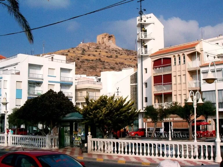
VillageCastell de Ferro is a fishing and beach village on the eastern Costa Tropical, the seat of the municipality of Gualchos in Granada province, under a hill crowned by an old castle. It has a long town beach with a promenade, Playa del Sotillo, and small coves such as La Rijana and Cambriles on either side. You reach it by car on the A-7 motorway or the N-340 coast road; Motril is 23 km away by road and Granada 82 km. It suits families and anyone who wants a quiet, low-rise base with a castle walk and coves nearby; skip it if you want soft sand, nightlife or a choice of museums.
Quick facts
- Names: Castell de Ferro; until the 19th century Castil de Ferro, and Castel de Ferro in Madoz’s 1850 dictionary (Spanish Wikipedia).
- Where: the coast of the municipality of Gualchos, at the mouth of the Gualchos rambla, central-eastern Costa Granadina, Granada province, Andalusia. The hill village of Gualchos lies about 5 km inland.
- Coordinates: 36.7225, -3.3591 (village centre, OpenStreetMap).
- Population: 3,078 in 2022, 58% of the municipality (Spanish Wikipedia, from INE). Gualchos as a whole has 5,284 inhabitants (INE 2025), and its population can triple in the tourist season.
- Tourist centre: one of the five tourist centres of the Costa Tropical named by spain.info, with Almuñécar, Salobreña, Motril and La Rábita. Andalucía.org calls it one of the pioneers of tourism on the Granada coast.
- Known for: the castle on the hill, Playa del Sotillo, nearby coves and the sea procession of the Virgen del Carmen.
Access and parking
By car: the A-7 Autovía del Mediterráneo and the N-340 pass the village. The GR-5209 links it with Motril and the GR-5206 climbs to Rubite in the hills. Spanish Wikipedia gives road distances of 6 km to Gualchos, 23 km to Motril, 82 km to Granada and 91 km to Almería.
Airports: Granada (GRX) is about 64 km away in a straight line, Almería (LEI) about 89 km and Málaga (AGP) about 102 km.
Parking: we could not find an official source for car parks. The coves along the N-340 have no facilities.
By bus: we could not confirm current bus routes and timetables; check with the operator before you travel without a car.
What to expect
A small seaside village with a promenade, low buildings and greenhouses on the slopes behind. Andalucía.org describes Castell de Ferro as a seafaring village with a mild subtropical climate, calm sea and clear skies, and says its medieval castle has dominated the beach for centuries as a watchtower (Andalucía.org).
The castle. The castle stands on the hill above the village, at the mouth of the Gualchos rambla. Andalucía.org says it is of Roman origin (Andalucía.org); its present form belongs to the system of castles and towers that guarded this coast against Berber pirates, and Andalucía.org compares its structure with the castle of La Rábita. We could not confirm opening times or whether the interior can be visited.
History. After the Morisco rebellion and expulsion the place was abandoned. In the late 18th century people from Gualchos settled here with families of the fortress garrison, and in the mid-19th century fishing was the main activity, with boats coming from Catalonia; some Catalans stayed, and a Calle de los Catalanes survives. Castell de Ferro was a municipality of its own from 1857 to 1860 and is today the seat of the Gualchos town hall (Spanish Wikipedia).
Gualchos village. The old village of Gualchos sits about 330 m up at the foot of the Sierra de Lújar, 7 km from the coast (Andalucía.org). Its church of San Miguel stands on the site of the former mosque, and the Gualchos viewpoint looks over the village, the Sierra de Lújar and the castle of Castell de Ferro with the sea behind (Spanish Wikipedia). In the village a small heritage centre, the Banco de Sensaciones, shows a traditional house of the lower Alpujarra with tools and furniture donated by residents (Andalucía.org).
Beaches and coves
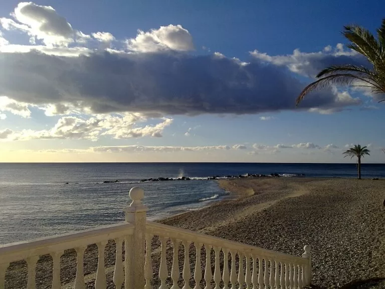
- Playa del Sotillo: the town beach, long, with artificial breakwaters along parts of it, a promenade and some services. Andalucía.org lists good access, calm water, lifeguards, public toilets and shade (Andalucía.org).
- Cambriles: just east of the village and shared between Gualchos and Lújar; not very busy and with few services (Andalucía.org).
- La Rijana: a small, isolated cove beside the N-340 with no facilities (Andalucía.org), about 3 km west of the village. A watchtower and an archaeological site stand on the rock above it (Spanish Wikipedia).
- El Lance and Casarones: further east, in the municipality of Rubite. El Lance is a narrow strip of dark sand beside the N-340 with some facilities and bars; Casarones is a small, narrow beach of rocks and gravel in a greenhouse area, with no services (Andalucía.org).
Practical details
- Health: the village has a primary care health centre with an emergency service; the reference hospital is the Hospital Santa Ana in Motril (Spanish Wikipedia).
- Festivals: San Juan bonfires on the beach on the night of 23 to 24 June, and the Virgen del Carmen in summer, with giants and big-heads, floats and a sea procession followed by fireworks over the water (Spanish Wikipedia).
- Prices and opening hours: none are given here, because we could not confirm them from an official source. The Gualchos town hall website could not be reached when we checked.
Accessibility and safety
Playa del Sotillo is the accessible beach, with good access to the sand and lifeguards in season (Andalucía.org). The coves along the N-340 have no services or lifeguards; take water and shade and do not walk along the road where there is no path. The castle is on a hill above the village; in summer go up early or late in the day.
Best time to visit
May to October for swimming; July and August are the busiest months, when the population of the municipality can triple. Spring and autumn are quieter and better for walking up to the castle and to Gualchos.
Nearby alternatives
- Calahonda (Motril): village beach with fine gravel and boats in the bay, about 6 km away in a straight line.
- Torrenueva Costa: beach town between Motril and Carchuna, about 12 km away in a straight line.
- Charca de Suárez Nature Reserve (Motril): wetland bird reserve by Playa Granada, about 16 km away in a straight line.
- La Rábita (Albuñol): castle village at the eastern end of the coast, about 17 km away in a straight line.
- Salobreña Castle: Nasrid castle above the white town of Salobreña, about 21 km away in a straight line.
- Camping Trevélez: mountain campsite in the Alpujarra, the nearest CostaMap campsite, about 31 km away in a straight line.
FAQ
Where is Castell de Ferro?
On the Costa Tropical in Granada province, about 23 km east of Motril by road, in the municipality of Gualchos.
Is Castell de Ferro beach sandy?
Not soft golden sand: like most of the Costa Tropical, expect dark, coarse sand and gravel. Playa del Sotillo, the town beach, has a promenade, lifeguards, toilets and shade.
Can you visit the castle of Castell de Ferro?
You can walk up the hill to the castle for the view. We could not confirm opening times or whether the interior is open.
Why does Castell de Ferro have a Catalan-looking name?
The old name was Castil de Ferro. Spanish Wikipedia links the change to Castell to Catalan fishermen and traders who settled in the 19th century; the name was fixed when the village became a municipality in 1857.
Sources and freshness
Checked 9 November 2026 · 14 sources Show
Checked 9 November 2026. Andalucía.org (Junta de Andalucía tourism) on Castell de Ferro, Gualchos, the castle, the castle of La Rábita (comparison), the Gualchos heritage centre, and the beaches of El Sotillo, Cambriles, La Rijana, El Lance and Casarones. Spain.info on the Costa Tropical. Background: Spanish Wikipedia on Castell de Ferro and Gualchos. Location and straight-line distances: OpenStreetMap contributors. Turismo de Granada (turgranada.es) and the Gualchos town hall site could not be reached. Not confirmed: castle opening, parking, bus timetables, beach lengths.
How this page is made. CostaMap is written with an AI editorial system run by Ebizapple. This page is based on the sources listed above. Last updated 9 November 2026. Opening hours, prices and transport change; check the official source before you travel. How we work · Partner links and ads