
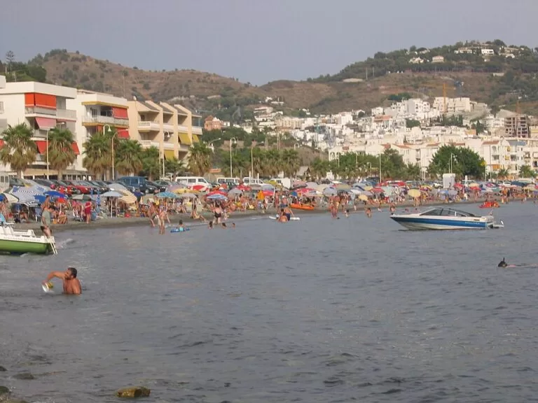
La Herradura is the beach village at the western end of the Costa Tropical, a district of Almuñécar in Granada province, about 4 km west of Almuñécar town on a horseshoe-shaped bay between the Cerro Gordo headland and the Punta de la Mona. You reach it on the old N-340 coast road or by bus from Almuñécar, and the village sits right behind its gravel beach. It is the diving and watersports base of this coast and the closest village to the Cantarriján naturist beach and the Maro–Cerro Gordo cliffs. It suits divers, snorkellers and families who want a sheltered bay; skip it if you want golden sand or a big resort.
Quick facts
- Names: La Herradura (“the horseshoe”, after the shape of the bay); the bay is the Bahía de La Herradura.
- Where: a village (pedanía) of the municipality of Almuñécar, Granada province, Andalusia, about 4 km west of Almuñécar town and next to the provincial border with Málaga.
- Coordinates: 36.7346, -3.7379 (village centre, OpenStreetMap).
- Size: Andalucía’s tourism site calls it Almuñécar’s second population centre; OpenStreetMap records 4,896 inhabitants for 2025.
- Beach: Playa de La Herradura, an urban family beach of dark gravel with a promenade, lifeguards and adapted facilities (Andalucía.org).
- Known for: scuba diving and the wreck of a Spanish fleet in the bay on 19 October 1562.
- Tourist information: Punto de Información Turística, Paseo Andrés Segovia 5 (annex of the municipal market), +34 958 618 636 (Andalucía.org).
Getting there and parking
By car: the village lies on the old N-340 coast road between Nerja and Almuñécar; from Nerja it passes through the Cerro Gordo tunnel before dropping to the bay (OpenStreetMap).
Parking: the old centre is a knot of narrow pedestrian lanes and steps around Calle Obispo and the Cuesta de Peralta, so park lower down. OpenStreetMap shows a surface car park near the school on the west side of the village and on-street parking along the seafront roads; we could not confirm summer charges. A paid motorhome area, the Aire Autocaravanas La Herradura, is about 300 m west of the centre.
By bus: OpenStreetMap maps urban bus lines 2A and 2B between Almuñécar and La Herradura, with stops on the Paseo Andrés Segovia and at the market, and ALSA intercity routes between Málaga and Motril stopping at La Herradura on the main road. Check current timetables before you travel; we could not open ALSA’s site from here.
What to see and do
The bay and the beach. Spain.info describes the beach as set between two mountains and well sheltered from the wind (spain.info). The headlands that close it are Cerro Gordo to the west and the Punta de la Mona to the east, which is why Andalucía’s tourism site calls the bay a natural harbour (Andalucía.org). The regional listing mentions calm water, lifeguards, shade, adapted toilets, amphibious chairs, a playground, showers and a diving zone (Andalucía.org). The surface is dark gravel, so bring water shoes.
Diving. Spain.info calls the bay a major centre for scuba diving and says the Almuñécar–La Herradura Sub-aquatic Reserve was created to protect its marine life, with artificial reefs that imitate sunken galleons and amphora factories, plus practice areas (spain.info). The regional tourism site lists several dive centres and a windsurf school in the village. The Cerro Gordo end of the bay belongs to the protected Maro–Cerro Gordo cliffs, whose marine strip has Posidonia meadows and orange coral (Andalucía.org).
The 1562 shipwreck. On 19 October 1562, in the reign of Philip II, a fleet sailing from Málaga towards Naples under Juan de Mendoza sheltered behind the Punta de la Mona from an easterly storm. The wind swung to the south, the ships were driven against each other and sank, and Andalucía’s tourism site estimates that about 5,000 people died (Andalucía.org). Spain.info gives 25 galleons lost (spain.info).
Castillo de La Herradura. Charles III ordered this small coastal fort in 1764 against pirate raids; it signalled to the watchtowers on Cerro Gordo and the Punta de la Mona. The army used it until 1839, then the Carabineros, and the Guardia Civil had a barracks here until 2003. Inside, the interpretation centre “1562 La Furia del Mar” tells the story of the shipwreck (Andalucía.org). OpenStreetMap places it on Calle Fortaleza, west of the old centre, with a start date of 1771.
The village. Andalucía.org describes La Herradura as “an old village, but a young one”: it now lives mainly from tourism services and building work, with some farming (Andalucía.org). The lanes behind the beach hold the church of San José, and the seafront Paseo Andrés Segovia has the municipal market, a monument to the men of the sea and beach showers (OpenStreetMap).
Beaches around La Herradura
- Playa de La Herradura: the main beach in front of the village, described above.
- Los Berengueles: a small, busy beach next to the Marina del Este marina, used mostly by people from the nearby housing estates (Andalucía.org).
- Cantarriján: a small naturist beach west of Cerro Gordo, at the provincial border, with a difficult access road (Andalucía.org). See our Cantarriján guide.
Practical details
- Where to stay: OpenStreetMap shows a guesthouse, apartments, a campsite (Camping La Herradura) and a motorhome area in or by the village; we do not list prices.
- Health: the Centro de Salud La Herradura is next to the market (OpenStreetMap, weekday mornings).
Accessibility and safety
The beach is the easiest part: the regional listing marks it accessible, with adapted toilets and amphibious chairs. The old village is steep, with stepped lanes. Swim within the lifeguarded area and keep clear of the anchoring and diving zones, where boats move. From 1 June to 15 October all use of fire is banned in Andalusia’s forests and the land around them, so no barbecues on the hills. Call 112 in an emergency.
Best time to visit
Summer is the beach season, with lifeguards on duty and the bay at its busiest. Divers want calm days; the sheltered bay helps when the wind blows elsewhere. Spring and autumn suit walks on Cerro Gordo.
Nearby alternatives
- Marina del Este, 1.4 km away: the small marina behind the Punta de la Mona, with dive centres and seafood restaurants.
- Playa de Cantarriján, 3.5 km away: the naturist beach below Cerro Gordo.
- Peñón del Santo, 3.9 km away: the rock and viewpoint between Almuñécar’s two town beaches.
- Castle of San Miguel, 4.1 km away: the castle above Almuñécar’s old town.
- Playa del Cañuelo, 4.7 km away: a gravel cove inside the protected cliffs, on the Nerja side.
- Maro–Cerro Gordo Cliffs, 5.9 km away: the protected strip of cliffs and coves between Nerja and La Herradura.
Distances are in a straight line from the village centre. More on this stretch in our Almuñécar and La Herradura guide.
FAQ
Where is La Herradura in Spain?
On the Costa Tropical in Granada province, Andalusia. It is part of the municipality of Almuñécar, about 4 km west of Almuñécar town and close to the border with Málaga province and Nerja.
Is La Herradura good for diving?
Yes. Spain.info calls the bay a major centre for scuba diving, with a sub-aquatic reserve and artificial reefs, and several dive centres work from the village and the Marina del Este.
What is the beach like at La Herradura?
An urban family beach of dark gravel in a sheltered bay, with a promenade, lifeguards, showers and adapted facilities, according to Andalucía’s tourism site.
How do I get to La Herradura without a car?
By bus: OpenStreetMap shows urban lines 2A and 2B from Almuñécar and ALSA intercity routes on the Málaga–Motril corridor stopping at La Herradura. Check current times before you travel.
Sources and freshness
Checked 9 November 2026 · 10 sources Show
Checked 9 November 2026. Official: Andalucía’s tourism site on La Herradura, the beach, the castle, Los Berengueles, Cantarriján, the Maro–Cerro Gordo cliffs and the tourist information point; spain.info on La Herradura and Almuñécar. Fire rules: Junta de Andalucía (Plan INFOCA), as summarised in our Costa Tropical guide. Location, population figure, streets, car parks, bus routes and distances: OpenStreetMap contributors (ODbL). Almuñécar’s own tourism website, Turgranada and ALSA could not be reached from here. Photo: Wikimedia Commons, licence as credited.
How this page is made. CostaMap is written with an AI editorial system run by Ebizapple. This page is based on the sources listed above. Last updated 9 November 2026. Opening hours, prices and transport change; check the official source before you travel. How we work · Partner links and ads