
Playa de Cantarriján (La Herradura, Almuñécar)
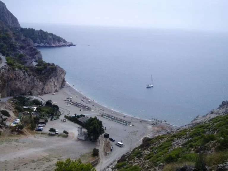
BeachPlaya de Cantarriján is a naturist beach of dark gravel at the bottom of a ravine, on the Granada–Málaga border just west of La Herradura (Almuñécar), inside the protected Maro–Cerro Gordo cliffs. You reach it from the old N-340 coast road above the Cerro Gordo tunnel, down a narrow track to the sand. Andalucía’s tourism site calls it a small, fairly busy nudist beach with a complicated access. It suits naturists, snorkellers and anyone who wants cliffs instead of apartment blocks; skip it if you do not want nudity around you or need easy access.
Quick facts
- Names: Playa de Cantarriján, often written Playa Naturista de Cantarriján; spelled Cantarrijan without the accent in English sources.
- Where: La Herradura, municipality of Almuñécar (Granada), at the provincial border with Nerja (Málaga), in the Paraje Natural Acantilados de Maro-Cerro Gordo (Andalucía.org).
- Coordinates: 36.7379, -3.7767 (OpenStreetMap).
- Type: naturist beach; clothing is optional, not required.
- Surface: dark gravel (Andalucía.org; OpenStreetMap). OpenStreetMap maps the beach as a strip roughly 300 m long.
- Services listed: lifeguards, public toilets, shade, sunbed and sunshade hire, sports equipment hire, cleaning and parking (Andalucía.org).
- Entry: free; we could not confirm parking charges.
Access and parking
By car: from the N-340 between Nerja and La Herradura, the Camino de Cantarriján leaves the road near the Cerro Gordo tunnel and winds down the ravine to the beach (OpenStreetMap). Andalucía’s tourism site warns that the access is complicated (Andalucía.org).
Restrictions: OpenStreetMap tags parts of the lower track as closed to motor vehicles and open to walkers. We could not confirm whether cars may drive down in summer or whether a shuttle bus runs; ask the Almuñécar tourist office (+34 958 631 125) before you go.
Parking: the official listing mentions parking, and OpenStreetMap shows a surface car park about 150 m from the sand at the foot of the track, plus on-street parking up on the Cerro Gordo estate by the viewpoint.
On foot: the walk down from the N-340 follows the winding track, several hundred metres and steep in places, and you climb back up at the end of the day.
By bus: OpenStreetMap shows no bus stop near the beach; the nearest are in La Herradura village, about 3.5 km away in a straight line.
What to expect
A small beach closed in by cliffs. Spain.info describes it as the place to practise naturism “at the bottom of a ravine” (spain.info), and Andalucía’s tourism site lists calm water, good access across the sand itself, and shade (Andalucía.org). The same listing flags it as an LGBTI-friendly, isolated beach with vegetation behind it.
- Naturism: it is one of four naturist beaches on the Costa Tropical, with El Muerto in Almuñécar, La Joya in Torrenueva Costa and Cala del Ruso in Albuñol. Clothing is optional, so expect both.
- Beach bars: OpenStreetMap shows two restaurants on the beach, La Barraca and Bola Marina. Check opening dates outside summer.
- Underwater: the sea here is part of the protected marine strip of the cliffs, one nautical mile wide, with Posidonia and Zostera seagrass meadows, sponges, anemones, moray eels and groupers, and populations of orange coral, a species listed as vulnerable (Andalucía.org). Bring a mask.
- Watchtowers: the Torre Vigía de Cerro Gordo, a watchtower about 11 m tall, stands on the headland east of the beach, and the Torre de Caleta on the cliffs to the west (OpenStreetMap).
Practical details
- Bring: water shoes for the gravel, water and sun protection; there is little natural shade on the sand itself.
- Toilets: public toilets are listed by the regional tourism site.
- Prices: sunbed and parking prices are set by the operators each season; we did not find a dated official list.
- Contact: Almuñécar tourist office, +34 958 631 125.
Accessibility and safety
The track down is steep and narrow; the beach is not a good choice for wheelchair users or anyone who cannot manage a long uphill walk. Boats and jet skis must keep their distance from the beaches of the protected area, but swim inside the marked bathing area and watch for kayaks and boats near the rocks. Stay back from the cliff edges on the paths above. From 1 June to 15 October all use of fire is banned in Andalusia’s forests and the land around them: no barbecues. Call 112 in an emergency.
Best time to visit
Summer, when the lifeguards and beach bars work, is the main season; on summer weekends arrive early because the small car park fills. In spring and autumn the beach is quieter and the walk down cooler, but services may be closed. Snorkelling is best on calm, clear days.
Nearby alternatives
- Playa del Cañuelo, 1.4 km away: the next gravel cove west, on the Nerja side of the cliffs.
- Maro–Cerro Gordo Cliffs, 2.5 km away: the protected area the beach belongs to.
- La Herradura, 3.5 km away: the beach village in the next bay east, with dive centres.
- Marina del Este, 4.7 km away: the marina behind the Punta de la Mona.
- Torre de Maro, 5.1 km away: a watchtower above Maro beach.
- Caves of Nerja, 6.6 km away: the show cave above Maro.
Distances are in a straight line from the middle of the beach. More on this stretch in our Almuñécar and La Herradura guide.
FAQ
Is Cantarriján a nudist beach?
Yes. Andalucía’s tourism site lists it as a nudist beach, and it is one of four naturist beaches on the Costa Tropical. Clothing is optional, not required.
How do I get to Cantarriján beach?
Leave the N-340 between Nerja and La Herradura near the Cerro Gordo tunnel and follow the Camino de Cantarriján down the ravine. The access is steep and parts are closed to cars, so check the current arrangements with the Almuñécar tourist office.
Is there parking at Cantarriján?
The official listing mentions parking, and OpenStreetMap shows a small car park at the foot of the track. It fills early on summer days.
Are there lifeguards and toilets?
Andalucía’s tourism site lists a lifeguard service, public toilets and shade, as well as sunbed and sunshade hire. Expect them in summer.
Is Cantarriján good for snorkelling?
Yes. It lies inside the protected marine strip of the Maro–Cerro Gordo cliffs, with seagrass meadows and orange coral, and the water is usually calm.
Sources and freshness
Checked 9 November 2026 · 6 sources Show
Checked 9 November 2026. Official: Andalucía’s tourism site on Playa de Cantarriján (type, services, surface), Almuñécar and the Maro–Cerro Gordo cliffs; spain.info on Almuñécar. Naturist beaches of the coast and fire rules: our Costa Tropical guide. Location, track, car park, restaurants, towers and distances: OpenStreetMap contributors (ODbL). Almuñécar’s own tourism website and Turgranada could not be reached from here, so summer access rules are not confirmed. Photo: Wikimedia Commons, licence as credited.
How this page is made. CostaMap is written with an AI editorial system run by Ebizapple. This page is based on the sources listed above. Last updated 9 November 2026. Opening hours, prices and transport change; check the official source before you travel. How we work · Partner links and ads