
Playa del Cañuelo, also called Cala del Cañuelo, is a gravel beach below the cliffs of the Maro-Cerro Gordo natural area, in the far east of Nerja (Málaga), about 7.6 km east of the town centre. You reach it from the N-340 coast road on a 1.3 km unpaved road down the cliff; OpenStreetMap tags that road as closed to private motor vehicles, so check how access works on the day before you set off. Down at the sea there are beach bars, showers and clear water for snorkelling, with boats often anchored offshore. It suits swimmers and snorkellers who do not mind a steep approach; skip it if you want soft sand or easy access.
Quick facts
- Names: Playa del Cañuelo, Playa El Cañuelo or Cala del Cañuelo (Spanish playa is beach, cala cove). Not to be confused with the Playa del Cañuelo near Tarifa in Cádiz.
- Where: Maro, municipality of Nerja (Málaga), near the border with Granada province, inside the Paraje Natural Acantilados de Maro-Cerro Gordo.
- Coordinates: 36.7448, -3.7892.
- Size: about 10 m wide. Official sources disagree on length: andalucia.org gives 640 m, spain.info 350 m.
- Surface: gravel and pebbles, with rocks at both ends.
- Water: moderate waves (andalucia.org and spain.info).
- Facilities: restaurant and beach bar, showers, litter bins, cleaning service, anchoring area (andalucia.org).
- Entry: free.
Access and parking
The road down: the official Andalusian tourism site describes Cañuelo as an isolated beach with difficult access, set in a protected natural area (andalucia.org), and spain.info names the N-340 as the nearest road (spain.info). On OpenStreetMap an unnamed, unpaved road leaves the N-340 east of Maro and winds about 1.3 km down the cliff to the beach. It is tagged as closed to private motor vehicles. We could not confirm from an official source who may drive down, whether a shuttle runs, or the 2026 rules. Ask the Nerja tourist office before you go; the phone number on the official listing is +34 952 521 531.
Parking: OpenStreetMap shows a free roadside parking strip beside the N-340 at the top of the access road, and small parking areas near the bottom by the beach bars. Given the access restriction on the road, plan to park at the top unless you have confirmed otherwise. We could not confirm capacity.
On foot: from the top it is about 1.3 km down the road to the sand, and the same back up the cliff. Allow time for the climb back, and carry water.
By boat or kayak: andalucia.org lists an anchoring area, and spain.info notes that many boats anchor off the beach. Andalucia.org’s page on the Maro-Cerro Gordo cliffs suggests a boat trip as the way to see the places along this coast that are hard to reach by land. Spain.info gives Marina del Este, 13 km away, as the nearest marina.
By bus: we could not confirm a bus stop near the top of the access road.
What to expect
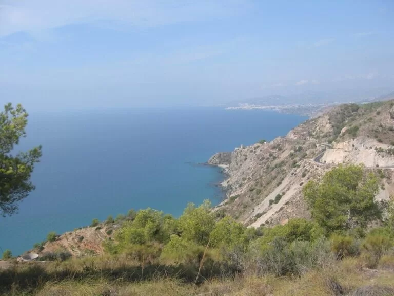
A long, narrow strip of gravel at the foot of steep slopes, with the cliffs of the natural area on either side. Spain.info notes that the rocks at each end make it a good beach for snorkelling, and that numerous boats are often anchored offshore. OpenStreetMap shows two restaurants or beach bars by the sand, one of them called Las Piedras. We could not confirm their opening dates or hours.
The beach lies inside the Paraje Natural Acantilados de Maro-Cerro Gordo, protected since 27 July 1989. According to andalucia.org, the natural area runs as a narrow strip along 12 km of coast between Nerja and Almuñécar and extends one mile out to sea, with cliffs up to 75 m high and small beaches and coves between them. Its seabed has meadows of Posidonia seagrass and populations of orange coral, a species listed as vulnerable, which is why the snorkelling here is good and why anchors and litter matter.
About 0.6 km east, on the headland, stands the Torre de Caleta, an old coastal watchtower. Cala de las Doncellas is a smaller cove 0.4 km to the south-east; OpenStreetMap shows paths along the shore towards it.
Practical details
- Bring water shoes. The beach is gravel and pebbles, not sand.
- Bring water for the walk back up the road, especially in summer.
- Respect the protected area: do not take stones, shells or plants, and take your rubbish home.
- Snorkel near the rocks at each end on calm days, and keep clear of anchored boats.
- Andalucia.org lists showers on the beach. We could not confirm whether they run outside summer.
Accessibility and safety
Cañuelo is not suitable for wheelchairs or for people who cannot manage a steep 1.3 km walk, unless vehicle access is confirmed. The beach is gravel and the sea can have moderate waves. We found no information on lifeguards for 2026; treat the beach as unsupervised. Keep away from the base of the cliffs and watch for boats close to the shore when you swim.
Best time to visit
June and September are good months for swimming with fewer people than in high summer. Calm mornings are best for snorkelling. Out of season, the beach bars may be closed, so bring food, and check the access rules for the road, which may differ from summer.
Nearby alternatives
- Maro–Cerro Gordo Cliffs Natural Park, 1.2 km away: our guide to the protected cliffs and their other coves.
- Torre de Maro, 3.8 km away: another coastal watchtower above the cliffs.
- Caves of Nerja, 5.3 km away: the show caves above Maro.
- Balcón de Europa, 7.7 km away: the viewpoint in the centre of Nerja.
- Castle of San Miguel, 8.7 km away: the castle above Almuñécar, east along the coast.
- Frigiliana, 10.9 km away: the white hill village behind Nerja.
Distances are in a straight line from the beach.
FAQ
How do I get to Playa del Cañuelo?
From the N-340 east of Maro, take the unpaved road about 1.3 km down the cliff. OpenStreetMap tags it as closed to private vehicles, so check the access rules with the Nerja tourist office before you go.
Is there parking at Cañuelo beach?
OpenStreetMap shows a free roadside parking strip beside the N-340 at the top of the access road. There are small parking areas near the beach, but the road down is restricted.
Can you swim and snorkel at Cañuelo?
Yes. Spain.info calls the rocks at each end ideal for snorkelling. The sea can have moderate waves and there is no confirmed lifeguard service.
Are there bars or restaurants at Cañuelo?
Yes. Andalucia.org lists a restaurant and a bar, and OpenStreetMap shows two by the sand. We could not confirm their 2026 season or hours.
Is Cala del Cañuelo the same as Playa del Cañuelo?
Yes, in Nerja both names are used for the same beach. There is a different Playa del Cañuelo near Tarifa in Cádiz.
Sources and freshness
Checked 6 November 2026 · 4 sources Show
Checked 6 November 2026. Official: andalucia.org, Playa El Cañuelo (Junta de Andalucía tourism: size, surface, facilities, access, phone), andalucia.org, Acantilados de Maro-Cerro Gordo (protection date, cliffs, seabed) and spain.info, Cala del Cañuelo (Turespaña: snorkelling, anchored boats, nearest marina and road). Location, access road and its restrictions, parking, restaurants and distances: OpenStreetMap contributors (ODbL). The Nerja town hall and Costa del Sol tourism websites could not be reached when we checked. Photos: Wikimedia Commons, licences as credited.
This place is part of our Costa del Sol travel guide: where it is, towns and beaches — see every town, beach and cove we have mapped on that coast.
How this page is made. CostaMap is written with an AI editorial system run by Ebizapple. This page is based on the sources listed above. Last updated 6 November 2026. Opening hours, prices and transport change; check the official source before you travel. How we work · Partner links and ads