
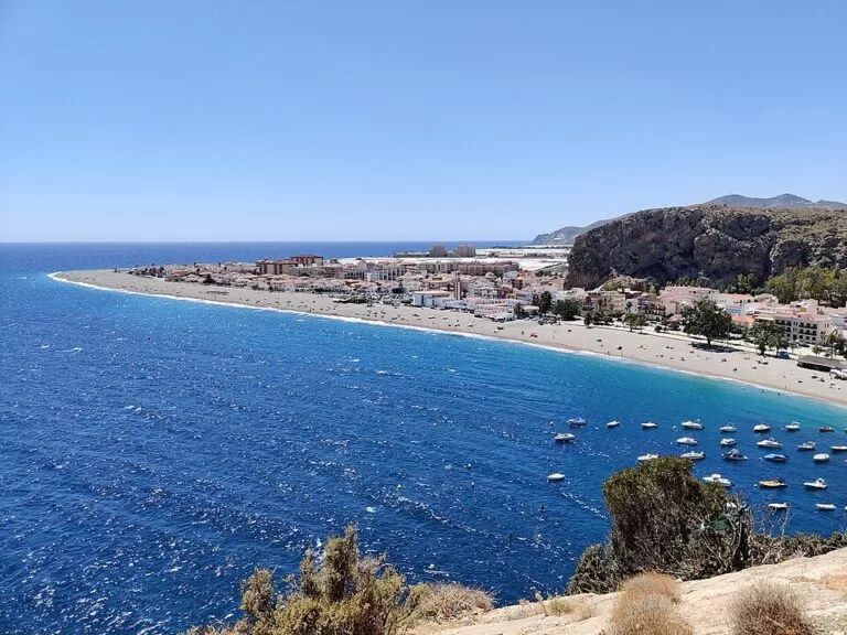
Calahonda is a fishing and beach village on the Costa Tropical in Granada province, part of the municipality of Motril and 13 km from the town, just east of the long beach of Carchuna. Andalusia’s official tourism site counts it among the most interesting resorts on the Granada coast for its beaches and its diving, and says its name refers to the deepest, clearest water on this shore. The village beach is about 1.4 km of dark sand with lifeguards in season and a Blue Flag, and the ALSA coast bus stops in the village. It suits families, snorkellers and divers who want a small, quiet base; skip it if you want an old town, sights or nightlife, and expect it to be full in July and August.
Quick facts
- Names: Calahonda (Granada), not to be confused with Calahonda in Mijas on the Costa del Sol or the cove of Calahonda in Nerja. Locals are called caleños.
- Where: Motril municipality, Granada province, Andalusia; postcode 18730. Since 2005 it forms the local entity of Carchuna-Calahonda with its neighbour Carchuna (Spanish Wikipedia).
- Coordinates: 36.7013, -3.4177 (village centre on OpenStreetMap).
- Population: 1,671 registered inhabitants in 2019 (INE, as given by Spanish Wikipedia). In summer the population multiplies with thousands of visitors (Andalucía.org).
- Distances: 13 km from Motril (Andalucía.org); in a straight line 2.4 km from Carchuna and 6.1 km from Torrenueva Costa.
- Beach: about 1,400 m by 40 m of dark sand, urban, with a Blue Flag regained in 2019 after three years without one.
- Village fiesta: the first weekend of August, for the Virgen del Carmen and San Joaquín.
Getting there and parking
By car: Calahonda lies on the N-340 coast road east of Motril, past Torrenueva Costa and Carchuna, on the eastern side of Cabo Sacratif. Spain.info gives the N-340 as the nearest road to the beach.
By bus: OpenStreetMap maps an ALSA bus stop called “Calahonda” in the centre, about 60 m from the village crossroads; Motril’s bus station is the nearest hub. We could not check timetables.
Parking: OpenStreetMap shows several free surface car parks in and around the village: one about 200 m from the centre near the beach, two at the western end towards Punta de Carchuna and two more at the eastern side. In August expect them to be full by late morning.
What to expect
A small resort that grew up around its port. Andalucía.org says the village took shape after the castle of Carchuna was built to defend this shore from Berber raids, which let people settle here safely; Spanish Wikipedia adds that most of what survives is from the 19th century, and that the church of La Purísima was finished in 1872, after which villagers no longer had to walk to Gualchos for mass. Andalucía.org’s page on Motril notes that Calahonda has a fishing port and good beaches within the municipality.
The beach is the centre of village life. Andalucía.org describes a well-equipped tourist beach next to the built-up area, busy with visitors, with good access to the sand, calm water, a lifeguard service, public toilets, shade and beach leisure (Andalucía.org). Spain.info calls it probably the best tourist beach in the area, with beach bars and restaurants, lounger hire, showers, a children’s area and a diving zone (spain.info).
Diving and snorkelling
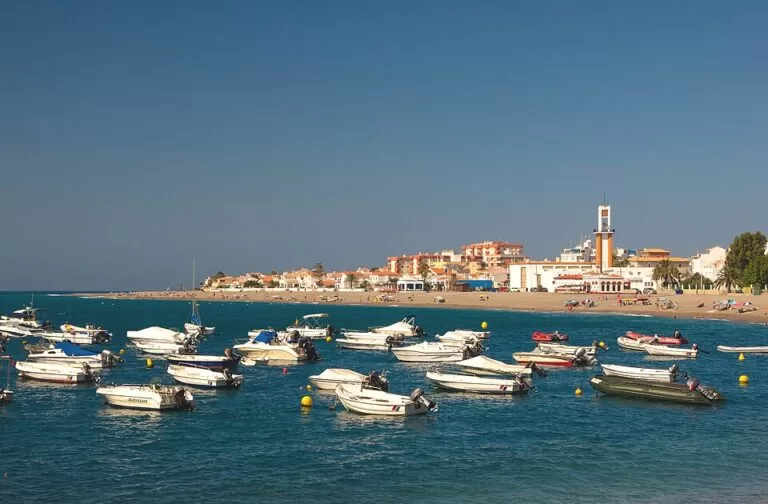
Calahonda is the diving village of this stretch. Andalucía.org lists a dive centre, Buceo Calahonda, with try dives, courses for all levels, boat and shore dives, equipment hire and a shop (Andalucía.org); OpenStreetMap maps a second dive centre at the western end of the beach. The rocky points either side of the bay, Punta de Carchuna to the west and Punta de Cerro Gordo to the east, frame the bay. Do not dive alone, and stay out of the boat channels.
Nearby history
- Fuerte de Carchuna, 1.7 km west, in the middle of Carchuna beach: an 18th-century coastal fort with a horseshoe-shaped front, round corner towers and a semicircular gun battery facing the sea, built for the defence of the coast of the old Kingdom of Granada (Andalucía.org). Spanish Wikipedia says it had four cannons, was badly damaged by French and then British forces, and was the scene of a rescue of Republican prisoners on 23 May 1938.
- Torre del Llano, about 0.7 km west at Punta de Carchuna: the ruins of a watchtower, mapped on OpenStreetMap.
- Atalaya del Zambullón, east of the village on a sheer cliff by the road to Castell de Ferro: a 16th-century watchtower that guarded the harbour mouth and the beach of La Rijana (Spanish Wikipedia).
Accessibility and safety
The beach has good access to the sand, calm water and a lifeguard service in season (Andalucía.org). Spain.info rates its occupancy as high, so arrive early in summer. The sand is dark and gets very hot in July and August. If you snorkel off the points, wear a bright buoy so boats can see you.
Best time to visit
June and September give warm water without the August crowds. July and August are the peak, when the village fills with visitors and the fiesta for the Virgen del Carmen and San Joaquín falls on the first weekend of August. Outside summer the village is much quieter.
Nearby alternatives
- Torrenueva Costa, 6.1 km away: a Blue Flag town beach, the naturist beach of La Joya and a 10 km cliff trail.
- Motril town guide, 10.4 km away: the bus station, the port and Playa de Poniente.
- Charca de Suárez, 11.4 km away: the wetland reserve behind Playa de Poniente, for birdwatching.
- Castillo de Salobreña, 16 km away: the Nasrid castle above Salobreña.
- Carchuna beach, 2.4 km west: about 3 km of beach with the fort in the middle, quiet despite its visitors and surrounded by greenhouses (Andalucía.org).
Distances are in a straight line from the village centre.
FAQ
Where is Calahonda in Granada?
On the Costa Tropical, 13 km east of Motril by the coast road, just past Carchuna on the eastern side of Cabo Sacratif. It belongs to the municipality of Motril.
Is Calahonda beach good for swimming?
Yes. It is about 1.4 km of dark sand with calm water, a lifeguard service in season and a Blue Flag, which it regained in 2019.
Can you dive in Calahonda?
Yes. Andalucía.org says Calahonda has good diving conditions and lists a dive centre offering try dives, courses and boat and shore dives.
How do I get to Calahonda without a car?
By ALSA bus along the coast: OpenStreetMap maps an ALSA stop in the village centre. Check current timetables at Motril bus station.
Is there parking in Calahonda?
Yes. OpenStreetMap shows several free surface car parks near the beach and at both ends of the village.
Sources and freshness
Checked 9 November 2026 · 10 sources Show
Checked 9 November 2026. Official: Andalucía.org (Junta de Andalucía tourism) on Calahonda (distance, diving, history), Calahonda beach (services, Blue Flag 2019), Motril, Fuerte de Carchuna, Carchuna beach and Buceo Calahonda; spain.info (Turespaña) beach sheet for Calahonda (Motril) (size, sand, services). Background (population, church, towers, fiesta, local entity): Spanish Wikipedia on Calahonda and Carchuna. Bus stop, car parks, capes and distances: OpenStreetMap contributors (ODbL). The Motril tourism and town hall sites could not be reached when we checked, so bus timetables and this year’s Blue Flag list are not confirmed. Photos: Wikimedia Commons, by Veinticuatro de Jahén (CC BY-SA 4.0) and Jebulon (CC0).
This place is part of our Costa Tropical, Spain: map, towns, beaches and where to stay — see every town, beach and cove we have mapped on that coast.
How this page is made. CostaMap is written with an AI editorial system run by Ebizapple. This page is based on the sources listed above. Last updated 9 November 2026. Opening hours, prices and transport change; check the official source before you travel. How we work · Partner links and ads