
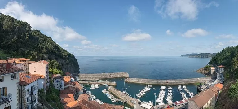
Elantxobe is a tiny fishing village on the coast of Bizkaia, in the Basque Country, built on the steep eastern side of Cape Ogoño, with its houses stepping down to a small harbour. It sits on the edge of the Urdaibai Biosphere Reserve, 1.5 km in a straight line from Laga beach and about 10 km north-east of Gernika. You reach it by car on a narrow road or by Bizkaibus. Come for the harbour and the viewpoints; skip it if you need easy parking, level streets or a beach in the village.
Quick facts
- Names: Elantxobe is the official Basque name; the Spanish form Elanchove was the official name until 1987 (Spanish Wikipedia).
- Where: 48310 Elantxobe, Bizkaia, on the east side of Cape Ogoño (279 m), in the Busturialdea district (Basque tourism board).
- Coordinates: 43.4026, -2.6400 (the church of San Nicolás de Bari, OpenStreetMap).
- Size: 1.90 km² and 346 residents, per the Basque tourism board; Spanish Wikipedia gives 320 (INE 2025).
- History: the village grew up around its fishing port from 1524 and was part of Ibarrangelu until 1858 (English Wikipedia).
- Entry: free; there is no ticketed sight.
Access and parking
By car: Elantxobe is about 10 km in a straight line from Gernika and 25 km from Bilbao Airport. Spanish Wikipedia explains that the slope is so steep that the village has two separate road accesses, one down to the port and one to the upper village. In the small upper square is a turntable that buses and other large vehicles use to turn round and leave. OpenStreetMap maps a free surface car park at the top of the village, about 450 m from the harbour on foot, and several small car parks along the road down to the port. Spaces are few, and in summer they fill quickly, partly with visitors to Laga.
By bus: OpenStreetMap shows two Bizkaibus stops, Bidekalea in the upper village, tagged with line A3513, and Kaia near the harbour. The Basque tourism board lists A3513 among the lines from Bilbao’s Termibus to Gernika. We could not open the Bizkaibus timetable, so check how many buses continue to Elantxobe before you travel.
On foot: the streets between the upper village and the port are steep and partly stepped. Allow time and wear good shoes.
What to expect
The Basque tourism board describes a village sheltered by Cape Ogoño and its cliffs, where the smell of salt leads you down to the port. Its piers were built in 1783 to hold back the waves and have since been strengthened. Along Calle Mayor, old sandstone walls are covered in plants, and the parish church of San Nicolás de Bari is dedicated to the patron saint of sailors. The houses are stacked one above the other, all facing the sea.
The port is still a working fishing port, though many of the boats are now pleasure craft. The fishermen’s guild has a fish market and cold stores, and the tidal range is 4.5 m, so the harbour looks very different at high and low tide. Spanish Wikipedia says that in the 19th century the village had seven pickling plants and a cannery, and that the church was built with the fishermen’s donations.
OpenStreetMap marks several viewpoints, among them Txorrotxu and Bidebarri above the harbour and Europa near the church, and a set of information boards around the port, including one at the guild building and one at the old Ogoño cannery. It also lists a small fishermen’s guild and fishing museum by the harbour, tagged as free and open at all hours; we could not confirm what it contains.
The Santa Catalina lighthouse centre in Lekeitio ends its visit with a virtual boat trip from Elantxobe to Lekeitio (Basque tourism board), a reminder that the two ports face the same stretch of coast.
Practical details
- Swimming: the village has no sandy beach. The nearest is Laga, in Ibarrangelu, 574 m of fine golden sand at the foot of Cape Ogoño, with lifeguards from 11:00 to 20:00 in summer, a surf school, parking and toilets (Basque tourism board).
- Festival: the patron saint, San Nicolás de Bari, is celebrated on 6 December (English Wikipedia).
Accessibility and safety
Elantxobe is built on a very steep slope. Streets are narrow, steep and partly stepped, so it is hard going with a wheelchair, a buggy or limited mobility; the harbour can be reached by road. Do not drive large vehicles into the lower village. Take care on the piers in rough sea, as they were built to stop the waves.
Best time to visit
Spring and autumn are calm and parking is easier. In summer, combine the village with a swim at Laga, but arrive early. The village fiesta is on 6 December.
Nearby alternatives
- Isla de Izaro – the island off the estuary mouth, 4 km west.
- Mundaka – surf village across the estuary, 5 km west.
- Bermeo – fishing port with the Fishermen’s Museum, 7 km west.
- San Juan de Gaztelugatxe – island hermitage, 13 km west.
FAQ
Is there parking in Elantxobe?
Yes, but little. OpenStreetMap shows a free car park at the top of the village and a few small ones on the road down to the port. In summer, arrive early.
Can buses get into Elantxobe?
Yes. Bizkaibus stops in the upper village and by the harbour, and large vehicles use a turntable in the upper square to turn round (Spanish Wikipedia).
Is there a beach in Elantxobe?
No. The nearest is Laga beach, about 1.5 km west in a straight line, with lifeguards in summer.
How do I get to Elantxobe from Bilbao?
By car via Gernika, or by Bizkaibus from Termibus; OpenStreetMap tags the village stop with line A3513. Check the timetable first.
What is the best time to visit Elantxobe?
Spring and autumn for quiet streets and easier parking; summer if you want to combine it with Laga beach.
Sources and freshness
Checked 9 November 2026 · 5 sources Show
- Checked 9 November 2026. Basque tourism board: Elantxobe
- Port of Elantxobe
- Laga beach
- Gernika (bus lines)
- Santa Catalina lighthouse. English Wikipedia and Spanish Wikipedia for background. Map data, car parks, bus stops and distances: OpenStreetMap
How this page is made. CostaMap is written with an AI editorial system run by Ebizapple. This page is based on the sources listed above. Last updated 9 November 2026. Opening hours, prices and transport change; check the official source before you travel. How we work · Partner links and ads