
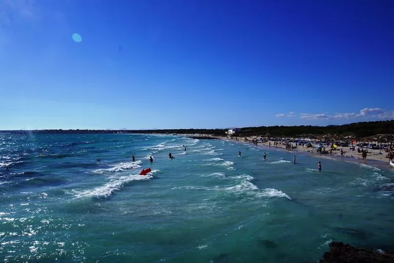
Es Trenc is the long, undeveloped white-sand beach on the south coast of Mallorca, in the municipality of Campos, between the hamlet of Ses Covetes and Colònia de Sant Jordi. You reach it by car from Campos or Colònia de Sant Jordi and park at one of three access points: Ses Covetes in the north, the paid car park at the middle of the beach, or the streets of Colònia de Sant Jordi in the south. Spain’s tourist board calls it the last unbuilt sandy beach of Mallorca, and it is part of a natural park. It suits people who want a long walk on soft sand, shallow clear water and space; skip it if you want shade, a promenade or a quiet beach in August.
Quick facts
- Names: Es Trenc; Platja d’es Trenc in Catalan, Playa de Es Trenc in Spanish. The northern end is also called Platja de Ses Covetes (or Platja des Morters), and the small southern beach before Colònia de Sant Jordi is Platja des Estanys, also called Es Coto.
- Where: the bay of Sa Ràpita on the south coast of Mallorca, municipality of Campos; the southern end touches the municipality of Ses Salines.
- Coordinates: 39.3422, 2.9858 (middle of the beach).
- Size: spain.info gives 3,000 m long and 20 m wide for the main beach; the sand continues for several kilometres from Ses Covetes to Es Coto (Catalan Wikipedia).
- Beach: fine white sand, dunes behind, calm and clear water most days.
- Protection: part of the Es Trenc-Salobrar de Campos maritime-terrestrial natural park since 2017; spain.info gives 1,492 hectares for the protected area of the beach and the Salobrar.
- Entry: free. Parking at the middle access is paid.
Access and parking
By car: Es Trenc is in the south of the island, below the town of Campos. Spain.info names the Ma-6101 as the nearest main road. Three places give access to the sand, and OpenStreetMap maps parking at each of them.
- Ses Covetes (north end): a small hamlet at the top of the beach. OpenStreetMap maps paid street parking, a few beach restaurants and toilets here, and the bus stop “ses Covetes / es Trenc” a few hundred metres from the sand.
- Es Trenc (middle): the paid car park “na Tirapel”, which OpenStreetMap marks as open from 09:00 to 21:00, about 300 m inland from the beach. Beside the dunes OpenStreetMap maps information points of the natural park, toilets and a beach restaurant.
- Colònia de Sant Jordi (south end): OpenStreetMap shows free street parking in the north of the village, close to Platja des Estanys, and a stop of TIB line 517 (“Sa Síquia”). From there you walk north along the shore onto Es Trenc.
By bus: OpenStreetMap maps bus stops at Ses Covetes, at the Sa Ràpita sailing club (lines 508 and 518) and in Colònia de Sant Jordi (TIB line 517). We could not open the TIB timetables, so check season and times with TIB before you rely on a bus.
On foot: the beach is flat and the walk along the sand from one access to the next takes time. In summer the car parks fill early.
What to expect
Spain.info describes Es Trenc as one of the best sandy beaches of Mallorca because it is the last one without buildings, is well preserved, and is the longest beach in the Ensenada de Sa Ràpita. That is also why it is busy: spain.info rates occupancy as high.
The beach is a natural dam between the sea and the low plain of Campos. Behind it lies Es Salobrar, which Catalan Wikipedia calls the second most important wetland of Mallorca after S’Albufera. The salt pans there are fed by a seawater intake on the beach, and fleur de sel is harvested at the Salines d’Es Trenc (English Wikipedia).
The sand is fine and white and the water clear. Along the beach you will see a few old structures: Catalan Wikipedia counts six Civil War bunkers, three huts, a restaurant and a small first-aid post. Off the middle of the beach lies a small islet, Illa Gavina, very close to the shore.
Nudism is practised in a part of the beach, according to spain.info, and OpenStreetMap tags the beach as clothing-optional. Families tend to stay near the ends at Ses Covetes and Colònia de Sant Jordi.
Practical details
- Spain.info lists sunshade and sun lounger rental, toilets, bins, a cleaning service and a telephone. There is almost no natural shade, so bring your own or rent one.
- Food: OpenStreetMap maps a beach restaurant at the middle access, marked open daily 10:00 to 19:00, and several restaurants at Ses Covetes. Opening hours change with the season; check on the day.
- Dogs: OpenStreetMap marks dogs as not allowed on the beaches at Ses Covetes and Sa Ràpita.
- Stay on the marked paths through the dunes. The dune system is protected and, according to Catalan Wikipedia, has been losing sand year after year.
- Take your rubbish home: there are few bins once you walk away from the access points.
Accessibility and safety
OpenStreetMap rates wheelchair access as limited: the paths cross soft sand and dunes. OpenStreetMap marks lifeguards at Ses Covetes and at Platja des Estanys near Colònia de Sant Jordi, and Catalan Wikipedia says only some stretches are supervised. When the west wind blows, strong currents form that can stop swimmers getting back to the shore (Catalan Wikipedia): stay close to the beach on windy days and swim near a lifeguard post with children.
Best time to visit
June and September give warm water and fewer people than July and August. In high summer arrive in the morning, before the car parks fill. On a day with a strong westerly wind, choose a sheltered cove on the east coast instead. Out of season the beach is quiet and good for long walks, though most beach services close.
Nearby alternatives
- Caló des Moro, 12.1 km east: a tiny, very popular cove of sand and rock in Santanyí, reached on foot.
- Cabrera Island National Park, 22.2 km south: boats leave from Colònia de Sant Jordi, at the southern end of Es Trenc.
- Aqualand El Arenal, 25.9 km north-west: a seasonal water park near Palma.
- Cala Varques, 31.9 km north-east: an undeveloped cove on the east coast, reached on foot.
- Palma Cathedral (La Seu), 38.3 km north-west: the Gothic cathedral on Palma’s seafront.
Distances are in a straight line from the middle of the beach.
FAQ
How do I get to Es Trenc?
Drive south from Campos towards Sa Ràpita, Ses Covetes or Colònia de Sant Jordi and park at one of the access points. Buses stop at Ses Covetes, Sa Ràpita and Colònia de Sant Jordi; check the TIB timetables first.
Is there parking at Es Trenc?
Yes. The car park in the middle of the beach is paid and, according to OpenStreetMap, open from 09:00 to 21:00. Ses Covetes has paid street parking, and Colònia de Sant Jordi has free street parking in the north of the village.
Is Es Trenc a nudist beach?
Partly. Spain.info says nudism is practised in a specific area of the beach; other stretches, especially near the ends, are used by families.
Can you swim at Es Trenc?
Yes. The water is usually calm and shallow, and lifeguards are marked at Ses Covetes and near Colònia de Sant Jordi. With a west wind, strong currents can form, so stay near the shore.
Are there toilets and sunbeds at Es Trenc?
Yes, at the access points. Spain.info lists toilets and sunshade and sun lounger rental; away from the access points the beach has no services.
Sources and freshness
Checked 9 November 2026 · 7 sources Show
Checked 9 November 2026. Official: Spain’s tourist board, spain.info, beach sheet Es Trenc (description, length, width, nudism area, protected area, services, access, nearest road). Background: Catalan Wikipedia, Es Trenc (natural park since 2017, Salobrar wetland, bunkers, islet, currents, dune erosion) and English Wikipedia, Es Trenc (salt pans). Location, parking, bus stops, toilets, lifeguards and dog rules: OpenStreetMap, including the na Tirapel car park, Platja de Ses Covetes and Platja des Estanys (© OpenStreetMap contributors, ODbL). The Balearic tourist board, the Campos town hall, the natural park pages of the Balearic government and the TIB timetables could not be opened when we checked, so parking prices and bus times are not given. Photo: Wikimedia Commons.
This place is part of our Balearic Islands travel guide: Mallorca, Menorca, Ibiza and Formentera — see every town, beach and cove we have mapped on that coast.
How this page is made. CostaMap is written with an AI editorial system run by Ebizapple. This page is based on the sources listed above. Last updated 9 November 2026. Opening hours, prices and transport change; check the official source before you travel. How we work · Partner links and ads