
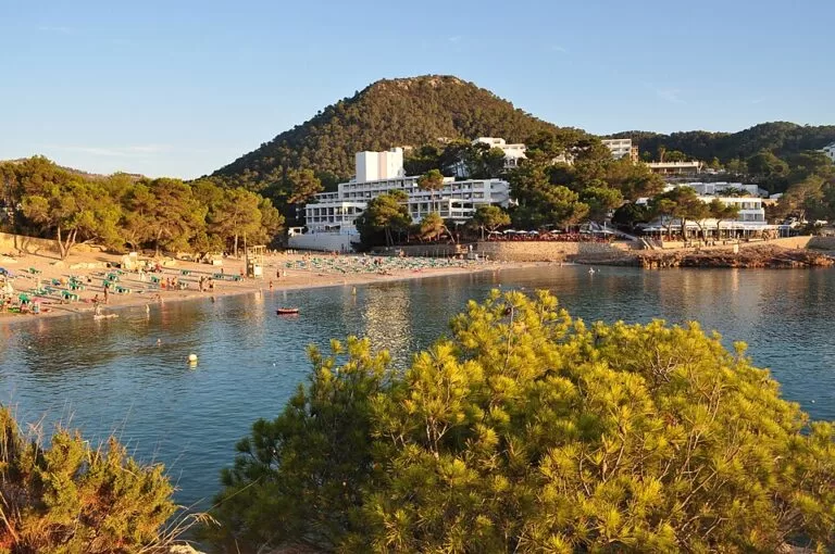
Portinatx is a small resort and former fishing village at the northern tip of Ibiza, in Sant Joan de Labritja, about 24 km north of Ibiza town and 29 km from the airport in a straight line. It is built round the most northerly bay on the island, with three sandy beaches, shallow water close to shore and pine-covered hills behind; Wikipedia counts it as about an hour by road from the airport. You come by car, by the infrequent bus from Ibiza town or by summer boat. It suits families and anyone who wants a quiet base with easy swimming; skip it if you want nightlife or a short trip to the rest of the island.
Quick facts
- Names: Portinatx (Catalan, pronounced roughly “por-tee-NATCH”); in Spanish sometimes Cala de Portinatx.
- Where: the north coast of Ibiza, municipality of Sant Joan de Labritja; Sant Joan village is 3.6 km south in a straight line.
- Coordinates: 39.1104, 1.5181 (the centre of the village, by the main beach; OpenStreetMap).
- Beaches: three: the largest on the bay (S’Arenal Gros on OpenStreetMap), the smaller S’Arenal Petit and Porto.
- Above the village: the wooded hill of Sa Descoberta, about 250 m high according to Wikipedia, about 1 km south of the beach.
- Nearby: the Moscarter lighthouse 1.5 km north-east, and Cala Xarraca 2.3 km west.
Access and parking
By car: Portinatx is at the end of the road north through Sant Joan de Labritja. Wikipedia describes it as a remote part of the island, about an hour from the airport, and notes that getting from here to other parts of Ibiza is slow (Wikipedia). A car gives you the most freedom here.
Parking: OpenStreetMap shows several surface car parks in the village: two beside the main beach and the bus stop, more on the slope above S’Arenal Gros, one by Porto beach and others towards S’Arenal Petit; one, Es Grop, is for customers only. We found no official parking prices.
By bus: OpenStreetMap shows the main stop, “Portinatx”, with a shelter, right by the main beach, and further stops at the hotels junction and the campsite on the way in. Wikipedia gives line 20 to Ibiza town and says it runs only every few hours in summer and twice a day in winter; we could not open the operator’s site to confirm the current timetable, so check it before you rely on it.
By boat: Wikipedia mentions an infrequent boat service to Es Canar and Port de Sant Miquel. We could not confirm the current season or times.
What to expect
Spain.info describes Portinatx as a former fishing village with a rugged coastline and wide views (Spain.info). The shores of the municipality are dominated by cliffs, and the interior is mountainous; Punic and Muslim ruins show the area was settled in the ancient world. Sant Joan de Labritja is still more rural than the rest of Ibiza, living from farming and livestock (Spain.info).
The village itself is small and family-oriented rather than a party place, with a few shops, supermarkets and restaurants of various cuisines and prices. The beaches stay shallow for some distance, which suits children (Wikipedia). The countryside around is heavily wooded with pines, unlike much of Mallorca and Menorca.
The three beaches, as Spain.info lists them (Spain.info):
- The main beach on the bay (S’Arenal Gros): the largest, in the middle of the village, next to the bus stop and car parks.
- S’Arenal Petit: the small beach, more private, about 300 m south-west of the centre.
- Porto: surrounded by low hills covered in pines, about 450 m north-east.
For a walk, the Moscarter lighthouse stands on the point 1.5 km north-east of the village in a straight line. Wikipedia puts it at about an hour on foot from the centre. Its light is 93 m above the sea, with a range of 18 nautical miles (OpenStreetMap). OpenStreetMap also marks two viewpoints on the headland west of the main beach.
Practical details
- Services: OpenStreetMap shows a pharmacy near the main beach; Wikipedia mentions supermarkets, a tobacconist and cash machines.
- Emergency points: OpenStreetMap marks numbered emergency access points (for the 112 service) along the beaches and paths. Note the nearest number if you go off the main beach.
- Markets: Sant Joan de Labritja’s craft market, a short drive south, runs on Sundays from 10:00 to 16:00 (Spain.info, checked November 2026).
- Prices and hours: we could not open the town hall or island council sites, so we give no prices or opening times for the beaches or services.
Accessibility and safety
The bus stop and car parks are beside the main beach. We could not confirm step-free access to the sand, lifeguard cover or adapted facilities on any of the three beaches. The coast outside the bays is cliffs: stay on marked paths if you walk to the lighthouse, and carry water.
Best time to visit
The beaches are at their best for swimming in summer, when the bus runs more often (Wikipedia). If you come outside summer, a car makes much more sense: the bus drops to two a day in winter. For a quiet north-coast stay with day trips, combine Portinatx with Cala Xarraca, Sant Joan and the Sunday market.
Nearby alternatives
- Sant Joan de Labritja, 3.6 km: the village and municipality guide, with Cala de Sant Vicent and the north coast.
- Camping La Playa Ibiza, 13.3 km: the campsite at Es Canar, near the Wednesday Punta Arabí market.
- Santa Eulària des Riu, 14.1 km: the east-coast town with a marina and the Puig de Missa church.
- Cala Saladeta, 22 km: a small sandy cove on the north-west coast near Sant Antoni.
- Dalt Vila, 23.7 km: the walled old town of Ibiza town.
Distances are in a straight line from the centre of Portinatx.
FAQ
Where is Portinatx in Ibiza?
At the northern tip of the island, in the municipality of Sant Joan de Labritja, about 24 km north of Ibiza town in a straight line. Coordinates: 39.1104, 1.5181.
How do you get to Portinatx without a car?
By bus from Ibiza town: Wikipedia gives line 20, every few hours in summer and twice a day in winter; the stop is by the main beach. Check the current timetable before you go.
Is Portinatx good for families?
Yes. Wikipedia describes it as family-oriented rather than a party place, with small beaches that stay shallow for some distance.
How many beaches does Portinatx have?
Three: the main beach on the bay, the smaller and more private S’Arenal Petit, and Porto, framed by pine-covered hills (Spain.info).
Can you walk to the Portinatx lighthouse?
Yes. The Moscarter lighthouse is 1.5 km north-east of the village in a straight line; Wikipedia puts the walk at about an hour from the centre.
Sources and freshness
Checked 7 November 2026 · 1 source Show
Checked 7 November 2026.
- Spain.info: Cala de Portinatx (beaches, coast, history, Sant Joan)
- Spain.info: Sant Antoni de Portmany (Portinatx as a former fishing village)
- Spain.info: Ibiza markets
- Wikipedia: Portinatx (bus, boats, lighthouse walk, Sa Descoberta, services; background)
- OpenStreetMap: Portinatx, with the beaches, car parks, bus stops and the Moscarter lighthouse
- Photo: Wikimedia Commons
The Illes Balears tourism site returned errors and the town hall and island council sites could not be opened from our research setup, so bus times, boat times and prices are not given here.
How this page is made. CostaMap is written with an AI editorial system run by Ebizapple. This page is based on the sources listed above. Last updated 9 November 2026. Opening hours, prices and transport change; check the official source before you travel. How we work · Partner links and ads