
Burriac Castle (Cabrera de Mar)
Historic siteBurriac Castle (Castell de Burriac) is a ruined medieval castle on the summit of the Turó de Burriac, a hill of about 400 m in Cabrera de Mar, on the border with Argentona, about 5 km west of central Mataró on the Maresme coast north of Barcelona. You park at the Font Picant area above Cabrera de Mar, or walk up from Argentona, and climb the last stretch on foot to the round keep and the walls. It suits walkers and anyone interested in Iberian, Roman and medieval history who wants a wide view over the Maresme; skip it if you need step-free access or facilities, because this is an unstaffed ruin on a rocky summit.
Quick facts
- Names: Castell de Burriac or Castell de Sant Vicenç in Catalan; Castillo de Burriac in Spanish; Burriac Castle in English. The name Sant Vicenç was used until the 14th century.
- Where: summit of the Turó de Burriac, municipality of Cabrera de Mar, on the boundary with Argentona, Maresme comarca, province of Barcelona, inside the Serralada Litoral park.
- Coordinates: 41.5376, 2.3872 (castle, OpenStreetMap).
- Height: about 400 m above sea level (Catalan Wikipedia); Catalunya.com gives the hill as 401 m.
- First record: 1017, in a document of Countess Ermessenda and her son Berenguer Ramon I (Catalan Wikipedia).
- Protection: a Cultural Asset of National Interest (Bé Cultural d’Interès Nacional).
- Owner: the town council of Cabrera de Mar, which bought it in 1990 (Catalan Wikipedia).
- Distance: about 500 m in a straight line from the Font Picant car park; 1.2 km from the centre of Cabrera de Mar and 2.3 km from Argentona (OpenStreetMap).
Access and parking
By car: Catalan Wikipedia describes two approaches: from the Font Picant in Cabrera de Mar, the shortest route and the one with parking, and from Argentona along the Passeig de Burriac. Chains stop vehicles on the tracks, and the last part has to be walked. OpenStreetMap maps the Font Picant car park and picnic area on the Pista de Burriac, about 500 m west of the castle in a straight line. We could not confirm the size of the car park or whether it fills on weekends.
On foot: Catalunya.com, the official Catalan tourism site, says there are several paths to the summit and calls them peaceful walks for walkers of all ages. The path from Font Picant is short but climbs over rock near the top.
Public transport: Cabrera de Mar has a station on the R1 Rodalies line and a bus to Mataró and Barcelona (Catalunya.com). From the village it is an uphill walk of a little over a kilometre in a straight line to the summit, more on the paths.
What to expect
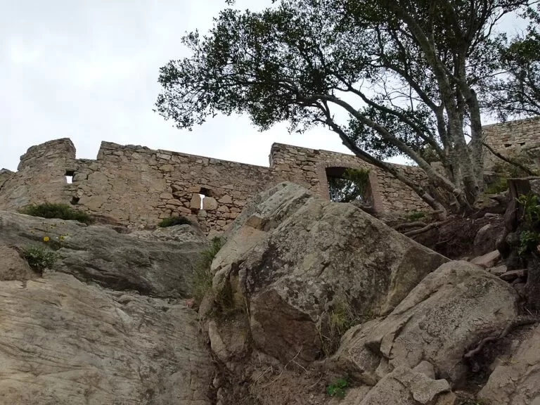
The castle is a walled ruin of irregular plan that follows the rock. The lower enclosure has a bastion beside the main gate and walled courtyards. The upper enclosure, the residence, is dominated by the round keep, with a reused Roman cistern at its foot, the noble halls and the chapel of Sant Vicenç (Catalan Wikipedia). Most of what you see dates from the 15th century.
The keep is the part most people photograph. Catalan Wikipedia gives it a wall 1.25 m thick and a height of about 15 m, with the door 3 m above the ground, once reached by a lifting ladder or a drawbridge. Of the chapel, parts of the vaults remain.
Below the castle, on the southern slope of the hill, are the remains of the Iberian settlement of Burriac, also called Ilturo or Ilduro. Catalunya.com calls it one of the most important Iberian sites in the area and the first historical capital of the Maresme, in the time of the Laietani. Catalan Wikipedia says it was lived in from the 6th to the 1st century BC, covered about two hectares and had a wall 1.40 m thick; it also says that the lack of maintenance after the digs has half-hidden some of the remains, so expect overgrown walls rather than a presented site.
The view is the other reason to climb. Catalan Wikipedia describes the summit as the best point for watching the Maresme coast and plain, from Vilassar to Caldes d’Estrac.
History in brief
The hilltop was an Iberian watchtower. Around the 2nd century BC the Romans turned it into a small fort, a lookout over the settlement below and the Argentona valley (Catalan Wikipedia). In the 1st century BC the main settlement moved down to the plain, to Iluro, present-day Mataró (Catalunya.com). The medieval castle is first recorded in 1017. In 1471 it passed to Pere Joan Ferrer, who called himself baron of the Maresme, lived in the castle and enlarged it into roughly its present shape. It fell out of use in the 18th century. Excavation and consolidation work took place in 1993 and 1994 (Catalan Wikipedia).
Practical details
- Opening and tickets: we found no official opening hours or ticket prices. It is an open ruin on a public hilltop; check with the town council of Cabrera de Mar for any guided visits.
- Facilities: none at the castle that we could confirm. OpenStreetMap maps a picnic area at Font Picant. Bring water.
- Time needed: about two hours from Font Picant, including time on the summit; half a day if you walk up from Cabrera de Mar or Argentona.
- Combine with: the Roman baths of Ca l’Arnau in Cabrera de Mar, which Catalunya.com calls the oldest in the Iberian Peninsula.
Accessibility and safety
This is not an accessible site. The final climb is on foot over rock and uneven ground, inside the walls there are steps and drops without railings, and the ruins are not staffed. Wear shoes with grip, keep children close near the walls, and do not climb on the masonry. In summer, check the Catalan forest-fire rules before you go.
Best time to visit
Autumn, winter and spring, when the air is clearer and the climb is cooler. In summer go early in the morning. Avoid the rocky top in strong wind or after heavy rain.
Nearby alternatives
- Vilassar de Dalt, 3.3 km away: a hill town with a castle, a Guastavino theatre and the Can Boquet dolmen.
- Illa Fantasia, 4.3 km away: the water park in Vilassar de Dalt, for a hot summer day.
- Mataró Museum, 4.8 km away: the city museum in Can Serra, with finds from the area.
- Iluro, 5.1 km away: the Roman town that replaced the hilltop settlement.
- Caldes d’Estrac, 12.3 km away: a small resort with thermal baths and a seafront promenade.
Distances are in a straight line from the castle. For the whole stretch, see our Mataró to El Masnou guide.
FAQ
How do I get to Burriac Castle?
Drive or walk to the Font Picant car park on the Pista de Burriac above Cabrera de Mar, then walk the last stretch up to the summit. You can also walk up from Argentona along the Passeig de Burriac.
Is there parking at Burriac Castle?
Yes, OpenStreetMap maps a car park and picnic area at Font Picant, about 500 m from the castle in a straight line. Vehicles cannot go further; chains block the tracks.
How long is the walk to Burriac Castle?
About 500 m in a straight line from Font Picant, with a steep, rocky end; longer from the villages of Cabrera de Mar or Argentona.
Is Burriac Castle free?
We found no ticket price or opening hours; it is an open ruin owned by the town council of Cabrera de Mar since 1990.
How old is Burriac Castle?
First recorded in 1017, on the site of an Iberian watchtower and a Roman fort; most of the standing ruin is 15th century.
Sources and freshness
Checked 9 November 2026 · 5 sources Show
Checked 9 November 2026. Official: Catalunya.com (Agència Catalana de Turisme) on Cabrera de Mar (castle and Iberian settlement, keep, R1 station and bus, Fira Iberoromana, Roman baths, height of the hill) and Argentona (paths to the summit, date 1017). Background: Catalan Wikipedia, Castell de Burriac (access, history, keep dimensions, ownership, excavations) and Poblat ibèric de Burriac (Iberian settlement). Location, car park and picnic area: OpenStreetMap contributors (ODbL). The Cabrera de Mar town council site could not be reached when we checked. Photo: Wikimedia Commons, licence as credited.
This place is part of our Costa del Maresme map and travel guide: Calella, Canet, Arenys and Mataró — see every town, beach and cove we have mapped on that coast.
How this page is made. CostaMap is written with an AI editorial system run by Ebizapple. This page is based on the sources listed above. Last updated 9 November 2026. Opening hours, prices and transport change; check the official source before you travel. How we work · Partner links and ads