
Calblanque Regional Park (Cartagena)
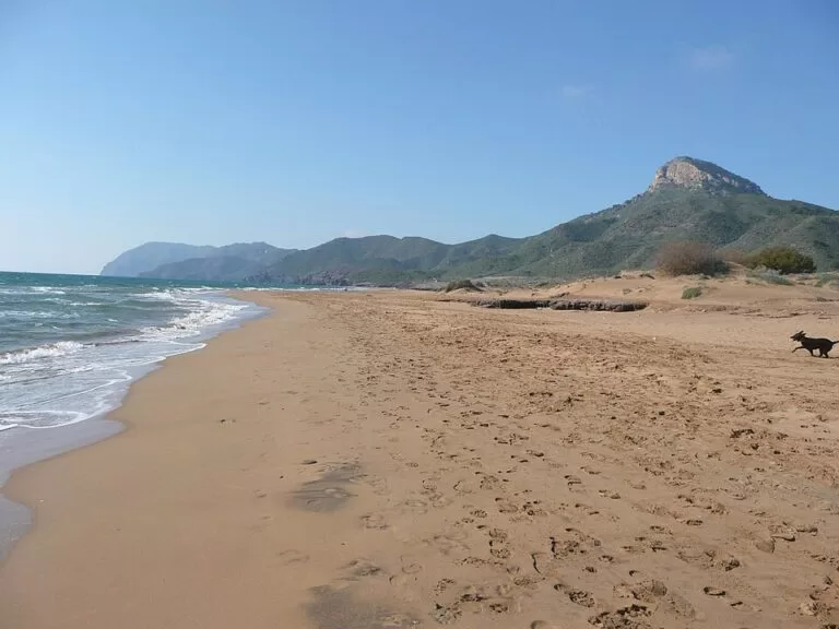
Natural parkCalblanque is a protected regional park of undeveloped beaches, dunes and salt pans on the Murcia coast, just south-west of Cabo de Palos and La Manga in the municipality of Cartagena. You reach it from the La Manga–Cabo de Palos road, and in summer car access is regulated to protect the dunes. Its main beach, Playa de Calblanque, is 300 m of fine golden sand with no buildings behind it. It suits people who want a natural beach and are happy to carry everything in; skip it if you want bars, sunbeds and shade on the sand.
Quick facts
- Full name: Parque Regional de Calblanque, Monte de las Cenizas y Peña del Águila.
- Where: the eastern end of the Sierra minera de Cartagena–La Unión, near the Mar Menor and Cabo de Palos (Murcia). Almost all of it lies in Cartagena; a small part is in La Unión.
- Coordinates: 37.6037, -0.7302, at Playa de Calblanque.
- Protection: regional park under the 1992 Murcia land law, and a Site of Community Importance in the EU Natura 2000 network.
- Beaches: east sector: Calblanque, Cala Arturo, Cala Magre and Cala de los Dentones; west sector: Playa Parreño, Playa Negrete, Playa Larga and Playa de las Cañas. Cala del Barco, also in the park, is reached through the La Manga Club resort (Murcia tourism board).
- Playa de Calblanque: 300 m long, 40 m average width, fine golden sand, gentle bathing conditions.
- Visitor centre: Las Cobaticas, about 2.5 km west of the main beach; phone 649 227 582.
- Entry: free.
Access and parking
By car: the Murcia tourism board gives this route: the A-7 Alicante–Cartagena motorway, exit 800 for the Mar Menor and La Manga–Cabo de Palos, then the MU-312 fast road and the Calblanque exit. Inside the park, dirt tracks lead to the car parks behind the beaches.
Summer access rules: in summer so many people come that the regional government regulates access by motor vehicle to protect the park. The scheme is called “Calblanque 4:40”, and its current dates, times and any bus service are published on the regional nature website, murcianatural.carm.es. Check it before you set off, because it changes from year to year.
Parking: the tourist board describes parking in a reserved, supervised area. On OpenStreetMap, two unpaved car parks lie 265 m and 370 m from Playa de Calblanque, one marked with 34 spaces, and a third sits about 600 m east by a bus stop called “Area Calblanque”.
What to expect
A wild stretch of coast between the mining hills and the sea. The tourist board describes long beaches of golden and ochre sand, quiet coves, fossil dunes, white salt pans and mountains behind. The Salinas del Rasall, the park’s wetland, lie just behind the shore; Spanish Wikipedia lists flamingos, avocets, egrets and stilts there, and the fartet, a small fish found only in this part of Spain.
The park’s most unusual feature is its fossil dunes: old dunes turned to rock behind the first line of loose dunes, shaped by the sea into odd forms where they reach the shore. Do not walk on the living dunes in front of them. On the hills grows the Cartagena cypress (Tetraclinis articulata), a botanical relic from the Tertiary that Wikipedia calls the jewel of the park, and the cliffs and mountains hold peregrine falcons, eagle owls and Bonelli’s eagles.
There are no buildings on the beaches. OpenStreetMap maps no bar, restaurant or shop within about a kilometre of Playa de Calblanque, only two simple shelters. People have mined these hills since Roman times, and the bay of Portmán, 11 km to the west, was the site of a major mining pollution disaster.
Practical details
- Bring everything: water, food, shade and a bag for your rubbish. Plan on carrying it from the car park.
- Visitor information (tourist board): Las Cobaticas visitor centre, 9:00–11:00; the information point at the main entrance, 11:30–14:30. Call 649 227 582 to check before you go.
- Nudism: spain.info says nudism is allowed on Playa de las Cañas, in the park’s western sector.
- Walking: the park has trails through the hills and along the coast; ask at Las Cobaticas for the routes.
Accessibility and safety
The tourist board’s 2026 accessibility data for Playa de Calblanque lists one parking space for people with reduced mobility, on loose earth, and one adapted portable toilet whose access ramp is too steep (36%). There is no accessible walkway to the information panel. The paths to the sand are loose and sandy. There is no shade, so in summer take care with heat and sun. Check the lifeguard season before you swim.
Best time to visit
May, June and September give warm days without the summer access restrictions at their strictest. In July and August, arrive early and check the access scheme first. Spring and autumn are the best seasons for walking in the hills.
Nearby alternatives
- Cabo de Palos, 3.9 km away: the fishing village and lighthouse on the cape, with restaurants and a small harbour.
- La Manga del Mar Menor, 4.6 km away: the long built-up sand bar between the Mar Menor and the Mediterranean.
- Islas Hormigas (Cabo de Palos), 9.2 km away: the islets of the Cabo de Palos marine reserve, a well-known dive site.
- Isla Perdiguera (Mar Menor), 12.3 km away: an island in the Mar Menor lagoon, reached by boat.
- Cala Cortina (Cartagena), 21.7 km away: Cartagena’s town cove, with services.
Distances are in a straight line from Playa de Calblanque.
FAQ
Can you drive to Calblanque beach?
Outside summer, yes, along the park’s tracks to the car parks behind the beaches. In summer, car access is regulated under the “Calblanque 4:40” scheme; check murcianatural.carm.es for the current rules.
Is there parking at Calblanque?
Yes. OpenStreetMap shows unpaved car parks 265 m and 370 m from Playa de Calblanque, and another about 600 m east by the bus stop.
Are there bars or toilets at Calblanque?
There are no bars on the beaches. The tourist board lists one portable adapted toilet at Playa de Calblanque. Bring water and food.
Which is the best beach in Calblanque?
Playa de Calblanque, in the east sector, is the main one: 300 m of fine golden sand, 40 m wide, with gentle bathing. Cala Arturo and Cala Magre are small coves just east of it.
Is Calblanque a nudist beach?
Nudism is allowed on Playa de las Cañas, in the west of the park, according to spain.info.
Sources and freshness
Checked 6 November 2026 · 5 sources Show
Checked 6 November 2026. Official: Murcia tourism board, Playas de Calblanque (beach list, size, directions, access scheme, information points, phone, 2026 accessibility data) and spain.info on Calblanque and Las Cañas (nudism). Background: Spanish Wikipedia (protection, geology, flora, fauna, mining). Location, car parks, bus stop, facilities and distances: OpenStreetMap contributors (ODbL). Photos: Wikimedia Commons, licences as credited. The regional nature website with the summer access details could not be reached when we checked.
How this page is made. CostaMap is written with an AI editorial system run by Ebizapple. This page is based on the sources listed above. Last updated 6 November 2026. Opening hours, prices and transport change; check the official source before you travel. How we work · Partner links and ads