
Port de Sóller (Sóller, Mallorca)
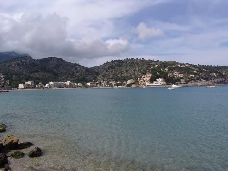
MarinaPort de Sóller is the harbour village of Sóller, on a small bay with a narrow mouth on Mallorca’s north-west coast, 3 km from Sóller town in the Serra de Tramuntana. The classic way in is the historic Sóller tram, which runs from the town to the harbour front, or the bus from Palma; drivers come on the Ma-11 and use the paid car parks by the quays. The harbour has a marina, a fishing quay and boats that run along the coast to Sa Calobra. It suits day-trippers on the train and tram, walkers and people who want a calm bay with a sandy beach. Skip it if you want nightlife or a large luxury marina.
Quick facts
- Names: Port de Sóller (Catalan, official); Puerto de Sóller in Spanish.
- Where: municipality of Sóller, north-west Mallorca, in the Serra de Tramuntana. About 3 km from Sóller town (Wikipedia). Population 2,438 in 2022 (INE, via Wikipedia).
- Coordinates: 39.7978, 2.6947 (harbour).
- The bay: the Badia de Sóller lies between cap Gros and the Forat des Dragó. Its mouth is 450 m wide, and inside the two capes it widens to 830 m (Wikipedia).
- Marina: OpenStreetMap shows a marina run as Marina Tramontana inside the harbour, listing VHF channel 9, water, electricity, wi-fi, toilets and showers.
- Berths: we could not reach the marina operator’s or the Balearic ports authority’s websites, so we do not give a berth number here.
- Entry: the harbour front and promenade are free to walk.
Access and parking
By tram: the Sóller tram links the town with the port along the beach-side road. It opened in 1913, is about 5 km long, and some of its original 1913 cars are still in service (Wikipedia). The harbour stop, Port de Sóller – Marysol, is about 0.15 km from the marina; OpenStreetMap marks the tram stops as not wheelchair accessible. Check the operator’s current timetable and fares before you go.
By bus: the Port de Sóller bus stop, about 0.55 km from the harbour, is served by lines 203 and 204 to Palma (line 203 via Valldemossa), line 231 to Alcúdia and line 232 to Fornalutx, according to OpenStreetMap. Check the current TIB timetables before travelling.
By car: the Ma-11 road links Sóller with the port (Wikipedia). OpenStreetMap shows several car parks close to the water: a paid car park on the fishing quay (Moll pesquer) and a paid 30-space car park, both about 0.2 km from the harbour; the paid Port de Sóller (centre) car park 0.3 km away; the free el Polvorí car park 0.3 km away; and the paid Infante Lois car park 0.45 km away. We could not check their rates.
By boat: OpenStreetMap shows a ferry route from Port de Sóller to Sa Calobra, with a stop at Cala Tuent. We could not confirm the operator, timetable or season.
What to expect
A small resort of shops, restaurants and hotels around a sheltered bay. English Wikipedia calls it quiet and away from the island’s big resorts. The harbour sits on the north side of the bay, with the marina, the fishing quay and the boat departures close together. A promenade runs around the bay, with beaches along it: platja de Can Generós next to the harbour, platja des Través further south and platja d’en Repic, the sandy beach Wikipedia names for the village, at the far end of the bay, about 0.7 km away (OpenStreetMap).
Two lighthouses stand on the headlands on either side of the bay; development on the eastern headland has been prevented because the Spanish Army uses it as a training ground (Wikipedia). On the western side, the Far de sa Creu lighthouse is about 0.45 km from the harbour. Above the bay is the Torre Picada, a 16th-century watchtower built against pirates, and the old oratory of Santa Caterina, about 0.3 km west of the harbour, now houses the Museu de la Mar, a museum of the sea (Wikipedia). The river mouth and bay attract little egrets, gulls and several kinds of ducks and geese.

Services for visiting boats
We could not reach the marina operator’s pages or the Balearic ports authority, so we cannot confirm berth numbers, sizes, rates or fuel. OpenStreetMap lists these details for the marina, which we could not check with the operator:
- VHF channel 9.
- Drinking water, electricity and wi-fi.
- Toilets and showers.
OpenStreetMap also marks public toilets on the quay, marked as wheelchair accessible. Book ahead in summer and check with the marina before arriving.
Prices and opening
There is no charge to walk around the harbour or the bay. The tram, buses, boat trips and car parks are paid; we could not check current prices, so check with each operator. OpenStreetMap marks the Museu de la Mar as free; confirm its opening hours locally.
Accessibility and safety
The promenade around the bay is flat. The tram stops are marked as not wheelchair accessible on OpenStreetMap, so wheelchair users may find the bus or a car easier. Keep children away from the quay edges, where boats come and go, and swim at the beaches, not in the harbour.
Best time to visit
Spring and autumn suit walking in the Serra de Tramuntana, with the port as a base or an end point. Summer is the beach season; arrive early in the day if you want a parking space close to the water. The harbour front is worth a stroll in any season.
Nearby alternatives
- Serra de Tramuntana, 4 km away (to the park’s centre point): the mountain range around Sóller and its valley.
- Torrent de Pareis, 13 km away: the gorge that ends at Sa Calobra, the end point of the boat route from the port.
- Palma Cathedral (La Seu), 26 km away: reached on bus 204 to Palma.
- Puerto Portals, 32 km away: the big upmarket marina on the Bay of Palma.
Distances are in a straight line from the harbour.
FAQ
How do I get to Port de Sóller?
From Sóller town by the tram or the Ma-11 road. From Palma, take bus 204 or 203, or drive to Sóller and change to the tram.
Is there parking in Port de Sóller?
Yes. OpenStreetMap shows paid car parks on the fishing quay and in the centre, and a free car park at el Polvorí, all within about 0.3 km of the harbour.
Can you swim in Port de Sóller?
Yes, at the beaches around the bay: platja de Can Generós beside the harbour, and the larger sandy platja d’en Repic at the far end. Do not swim in the harbour itself.
Can you take a boat from Port de Sóller to Sa Calobra?
OpenStreetMap shows a ferry route from the port to Sa Calobra with a stop at Cala Tuent. Check operators locally for the current season and times.
How many berths does Port de Sóller have?
We could not check a figure with the marina operator or the ports authority, so we do not give one. Ask them directly.
Sources and freshness
Checked 6 November 2026 · 6 sources Show
Checked 6 November 2026. Official tourism: Spain.info, Sóller. Village, bay, tram, lighthouses, birds and history: Wikipedia, Port de Sóller, Viquipèdia, Port de Sóller and Wikipedia (es), Puerto de Sóller. Location, marina details, car parks, tram and bus stops, bus lines, the Sa Calobra boat route, beaches, toilets and distances: OpenStreetMap (OpenStreetMap contributors, ODbL). The marina operator’s website and the Balearic ports authority (Ports IB) could not be reached for this update. Photos: Wikimedia Commons, licences as credited.
This place is part of our Balearic Islands travel guide: Mallorca, Menorca, Ibiza and Formentera — see every town, beach and cove we have mapped on that coast.
How this page is made. CostaMap is written with an AI editorial system run by Ebizapple. This page is based on the sources listed above. Last updated 6 November 2026. Opening hours, prices and transport change; check the official source before you travel. How we work · Partner links and ads