
Mirador de Sa Foradada (Son Marroig, Deià)
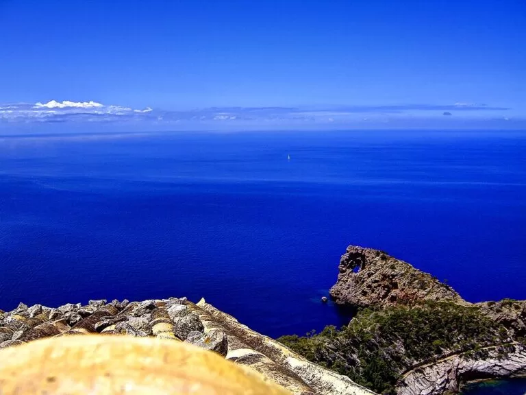
ViewpointThe Mirador de Sa Foradada is the viewpoint at Son Marroig on the Ma-10, about 1.7 km in a straight line from Deià, towards Valldemossa, looking down on Sa Foradada: a rocky peninsula with an 18 m hole through it. You park in the free Sa Foradada car park beside the road, walk about 150 m to the viewpoint, and can add the Son Marroig house museum (paid) or a 3 km walk down to the peninsula. It suits anyone driving the Tramuntana coast road and sunset photographers; skip it if you want a beach or a long stay without a car.
Quick facts
- Names: Sa Foradada, Na Foradada or La Foradada (Catalan, “the pierced one”). The tourism portal lists the spot as “Viewpoint Son Marroig”; OpenStreetMap names the roadside viewpoint Mirador de sa Foradada, next to the Mirador des Galliner.
- Where: Son Marroig, Ma-10 Valldemossa–Deià road, km 65.5, Deià (Mallorca).
- Coordinates: 39.7522, 2.6292 (the viewpoint by the road).
- The rock: a peninsula about 600 m long and 84 m high, pierced by a hole about 18 m across. Old maps show it as an islet.
- Who made the viewpoints: Archduke Lluís Salvador of Austria, who owned Son Marroig and had viewpoints built along the path between 1877 and 1884.
- Entry: the roadside viewpoint is free; the Son Marroig museum and gardens charge a ticket (see below).
- Parking: free car park “Sa Foradada”, 80 spaces (OpenStreetMap).
- Bus: stop “Sa Foradada (Deià)”, on TIB line 203 Palma–Valldemossa–Deià–Port de Sóller.
Access and parking
By car: Son Marroig is on the Ma-10 between Valldemossa and Deià, at km 65.5 (spain.info). The viewpoint is about 4.6 km in a straight line from Valldemossa and 1.7 km from Deià.
Parking: OpenStreetMap maps the free Sa Foradada car park for 80 cars just below the Son Marroig houses, about 150 m from the viewpoint.
By bus: the stop “Sa Foradada (Deià)” is on the Ma-10 about 340 m from the viewpoint, served by TIB line 203 between Palma, Valldemossa, Deià and Port de Sóller (OpenStreetMap). We could not confirm the 2026 timetable; check TIB before you go.
What to expect
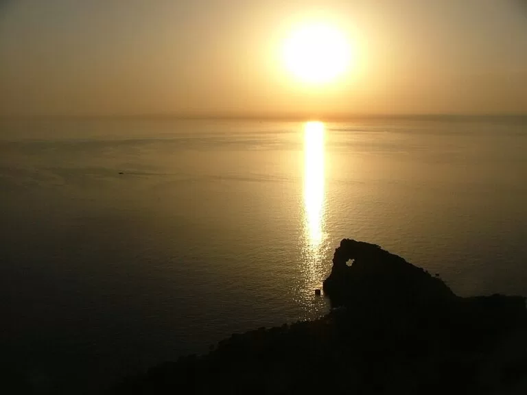
From the terraces you look out over the sea to the long, low rock of Sa Foradada and the hole through it. The Balearic tourism portal says the best place to see the hole is the viewpoint of Son Marroig, “especially at sunset” (illesbalears.travel). The Catalan Wikipedia adds that its image is one of the most used in Mallorca’s tourism promotion (Viquipèdia).
The story behind the view: Archduke Lluís Salvador bought Son Marroig in the 1870s together with the peninsula. Told he had paid too much, he is said to have replied that what he paid would not even cover the hole. He built the path down to Sa Foradada and a small quay for his yacht, the Nixe. In 1582, 150 North African corsairs were defeated here by 50 Christian defenders under Mateu Sanglada (tourism portal).
Right by the viewpoint, OpenStreetMap shows a restaurant, “Miradors de sa Foradada”. We could not confirm its opening hours or prices.
Son Marroig museum and the walk to the rock
Son Marroig house museum: a private museum since 1927, dedicated to the Archduke, with his drawings, books, maps and furniture, ceramics and paintings. In the garden is a white marble temple that serves as a viewpoint, plus the Des Galliner viewpoint. The tourism portal gives opening Monday to Saturday, 9:30–18:00, tickets €4, children free, and about an hour for the visit (checked November 2026, illesbalears.travel). OpenStreetMap shows a midday break (9:30–14:00 and 15:30–18:00), so confirm with the museum (+34 971 63 91 58) before you go. Since 1978 it has also hosted the Deià International Music Festival.
Walk to Sa Foradada: the tourism portal describes a 3 km route from the Son Marroig car park to the peninsula on the Archduke’s path, about two and a half hours there and back. The start is marked by iron bars by the houses (route page). The path runs over Son Marroig land; we could not confirm the current access rules, so ask at Son Marroig before you set off.
Accessibility and safety
The viewpoint is close to the road and the car park, but we could not confirm step-free access. If you come by bus, walk carefully along the Ma-10. On the path to Sa Foradada, wear proper shoes and carry water; the way back is uphill all the way.
Best time to visit
Sunset is the classic time, as both the tourism portal and the Discover the Tramuntana guide say (illesbalears.travel), so expect company then and allow time to find a space. If you want the museum too, note that the portal lists it as open Monday to Saturday only.
Nearby alternatives
- Deià town guide, 1.7 km away: the hill village of writers and musicians.
- Valldemossa town guide, 4.6 km away: the Royal Charterhouse and Chopin.
- Port de Sóller, 7.6 km away: the harbour along the coast to the north-east.
- Serra de Tramuntana, 10.1 km away (to the centre of the range): the World Heritage mountains around you.
- Mirador de Ses Ànimes, 13.4 km away: the watchtower viewpoint near Banyalbufar, further down the same coast road.
Distances are in a straight line from the viewpoint.
FAQ
Where is the Mirador de Sa Foradada?
At Son Marroig on the Ma-10 between Valldemossa and Deià, km 65.5, about 1.7 km from Deià. Coordinates: 39.7522, 2.6292.
Is there parking at Sa Foradada viewpoint?
Yes. OpenStreetMap maps a free car park for 80 cars, about 150 m from the viewpoint.
Do you need a ticket for the Sa Foradada viewpoint?
No, not for the roadside viewpoint. The Son Marroig museum and its marble temple viewpoint charge €4 (children free), according to the tourism portal, checked November 2026.
Can you walk to Sa Foradada?
The tourism portal describes a 3 km path from the Son Marroig car park, about 2.5 hours there and back. It crosses Son Marroig land, so check access on the day.
How big is the hole in Sa Foradada?
About 18 m across, in a rock about 600 m long and 84 m high.
Sources and freshness
Checked 6 November 2026 · 7 sources Show
Checked 6 November 2026. Official: Balearic tourism portal on the Son Marroig viewpoint, Son Marroig museum (hours, price), Son Marroig and Sa Foradada route and Tramuntana guide; spain.info, Son Marroig (address, km point). Background: Viquipèdia, Sa Foradada (size, dates of the viewpoints). Location, car park, bus stop and route, restaurant, museum hours tag and distances: OpenStreetMap contributors (ODbL). The Son Marroig website and the TIB timetable could not be opened. Photos: Wikimedia Commons, licences as credited.
This place is part of our Balearic Islands travel guide: Mallorca, Menorca, Ibiza and Formentera — see every town, beach and cove we have mapped on that coast.
How this page is made. CostaMap is written with an AI editorial system run by Ebizapple. This page is based on the sources listed above. Last updated 6 November 2026. Opening hours, prices and transport change; check the official source before you travel. How we work · Partner links and ads