
The Zumaia flysch is the cliff of tilted rock layers at Itzurun beach in Zumaia, Gipuzkoa, part of an 8 km strip of cliffs and tidal platform that runs west to Deba. Itzurun is a short walk from the town centre and about 1.2 km from Zumaia’s railway station, and the rock platform below the cliffs is only exposed at low tide. Since 2010 the area has been part of the Basque Coast Geopark, a UNESCO Global Geopark. It suits anyone curious about geology, walkers and photographers; skip it if you want a calm, sheltered swimming beach.
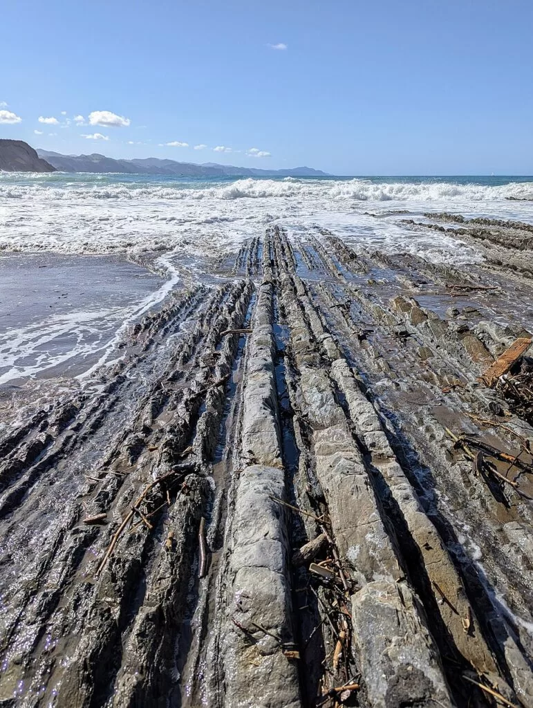
Quick facts
- Names: Zumaia flysch; Itzurun beach (Itzurun hondartza in Basque), also called San Telmo beach after the hermitage above it. Zumaia is Zumaya in Spanish.
- Where: Zumaia, Gipuzkoa (Basque Country), at the mouth of the Urola river, between Getaria and Deba.
- Coordinates: 43.3002, -2.2607 (Itzurun beach).
- What it is: about 8 km of cliffs and wave-cut platform between Deba and Zumaia, a protected biotope, inside the Basque Coast Geopark (Deba, Zumaia and Mutriku, 89 km²).
- Cliffs: up to about 150 m high above Itzurun, according to Tourism Euskadi.
- Beach: Itzurun is 270 m long, golden sand, with heavy swell.
- Entry: the beach is public; guided walks and boat trips are paid activities.
Access and parking
On foot from the town: Itzurun sits right at the edge of Zumaia’s urban area, below the San Telmo hermitage. Tourism Euskadi describes it as the beach nearest the village.
By train: Zumaia railway station is about 1.2 km in a straight line from the beach, per OpenStreetMap. Lurraldebus stops (Txomin Agirre, Patxita Etxezarreta) lie 550–700 m from the sand.
By car: the streets around the beach are mostly resident-permit and paid parking on OpenStreetMap. A free surface car park is mapped about 700 m from the beach, and paid car parks about 500 m away. In summer, expect to circle; the train is simpler.
What to expect
Flysch is a sequence of hard and soft marine rock layers laid down one after another. At Zumaia, earth movements tipped the originally flat layers upright, and the sea has worn the softer clay layers down into a flat platform, leaving the harder beds standing out as long ribs of rock (Tourism Euskadi, flysch biotope).
Geologists study this coast because the layers record around 50–60 million years of the Earth’s history in one readable sequence. Tourism Euskadi calls the cliffs at Itzurun the best spot to study two key moments in the Paleocene. The boundary that marks the end of the Cretaceous, the time of the mass extinction that ended the dinosaurs, is present at Itzurun (Wikipedia); the geopark guides can show you where.
The beach itself is a working town beach with a bar serving meals in summer, toilets, showers and a lifeguard. It is open to the Bay of Biscay, so surfers and bodyboarders use it; the western part, towards the rocks, has a sand-and-rock bottom and is for experienced surfers only.
The cliff walk west towards Deba follows the same rock sequence for kilometres. CostaMap has a separate guide to that walk (see below).
Practical details
- Tides: the platform is only walkable around low tide. Check a tide table before you go and plan your visit around low water.
- Guided visits: the Algorri Interpretation Centre and the Zumaia tourist office offer geology walks, hikes and boat trips along the protected strip (Tourism Euskadi). Algorri’s own guided tours on foot or by boat run on Saturdays.
- Algorri Interpretation Centre: Juan Belmonte 21, Zumaia. Hours listed by Tourism Euskadi (checked November 2026): March–June and September–November, Tuesday–Friday 10:00–13:30 and 16:00–18:30, Saturday 10:00–13:30 and 16:00–19:30, Sunday 10:00–13:30; July and August, Tuesday–Sunday 10:00–14:00 and 15:00–18:00; December–February, Thursday–Sunday only. Phone +34 943 143 100.
- Zumaia tourist office: phone +34 943 143 396.
- Beach services: lifeguards 10:30–19:30 (season dates not given), public toilet, showers, drinking fountains, bike parking, surf courses.
Accessibility and safety
The platform is slippery rock with deep gaps between the layers, and the tide comes back in across it. Do not walk out on a rising tide or in big swell, keep away from the foot of the cliffs where rock can fall, and wear shoes with grip. Itzurun has heavy swell; swim only in the lifeguarded area. OpenStreetMap marks the beach toilets as not wheelchair accessible, and we could not confirm step-free access to the sand.
Best time to visit
Pick a day with a low tide in daylight; that matters more than the season. Spring and autumn are quieter than July and August, when the beach and the town’s parking fill. Low sun in the morning or late afternoon brings out the relief of the rock ribs for photos. In winter, Atlantic storms make the platform dangerous; go only in calm weather.
Nearby alternatives
- Flysch Route: Zumaia to Deba coastal walk, starting here: the cliff-top walk along the whole flysch strip.
- Getaria, 4.7 km: the fishing village on the next headland east.
- Zarautz, 8.2 km: the longest beach in Gipuzkoa, and the coast’s learn-to-surf beach.
- Monte Igueldo, 20 km: the viewpoint over San Sebastián’s bay.
- Isla de Santa Clara, 21 km: the island in the middle of La Concha bay.
Distances are in a straight line from Itzurun beach.
FAQ
Where can I see the flysch in Zumaia?
At Itzurun beach, right by the town centre, below the San Telmo hermitage. The cliffs and the rock platform continue west for about 8 km towards Deba.
Do I need low tide to see the Zumaia flysch?
The cliffs are visible at any time, but the flat rock platform is only exposed around low tide. Check a tide table before you go.
Is it free to visit?
Yes, the beach is public. Guided geology walks and boat trips from the Algorri centre and the tourist office are paid.
How do I get to Zumaia by public transport?
Trains stop at Zumaia railway station, about 1.2 km from Itzurun, and Lurraldebus buses stop 550–700 m from the beach.
Can you swim at Itzurun beach?
Yes, with a lifeguard on duty from 10:30 to 19:30 in season. The swell is heavy and the western end has a sand-and-rock bottom.
Sources and freshness
Checked 6 November 2026 · 8 sources Show
Checked 6 November 2026. Official: Tourism Euskadi on Itzurun beach (length, services, lifeguard hours, surf), the tidal platform and flysch cliffs (8 km, biotope, geopark 2010, guided visits), the Basque Coast Geopark (area, 13 km of cliffs), Algorri Interpretation Centre (hours, tours) and Zumaia; spain.info, Zumaia. Background: Wikipedia, Zumaia (Cretaceous boundary). Location, station, bus stops, parking and distances: OpenStreetMap.
How this page is made. CostaMap is written with an AI editorial system run by Ebizapple. This page is based on the sources listed above. Last updated 6 November 2026. Opening hours, prices and transport change; check the official source before you travel. How we work · Partner links and ads