
Torrent de Pareis (Escorca, Mallorca)
Hiking trailThe Torrent de Pareis is the 3 km limestone gorge that cuts through Mallorca’s Serra de Tramuntana from s’Entreforc down to the sea at Sa Calobra, in the municipality of Escorca. The usual route starts at the trailhead on the Lluc–Sóller road at Escorca, goes down the camí des Burgar into the gorge and finishes on the pebble beach at Sa Calobra: measured on OpenStreetMap, that is about 6.3 km one way. This is not a footpath walk. The gorge floor is a dry riverbed of boulders that you climb over and down, often using your hands, and Spanish Wikipedia notes that it accounts for a quarter of mountain rescues in Mallorca. It suits fit, sure-footed hikers with some scrambling experience. Skip it if you are new to rough ground, have young children with you, or if it has rained recently.
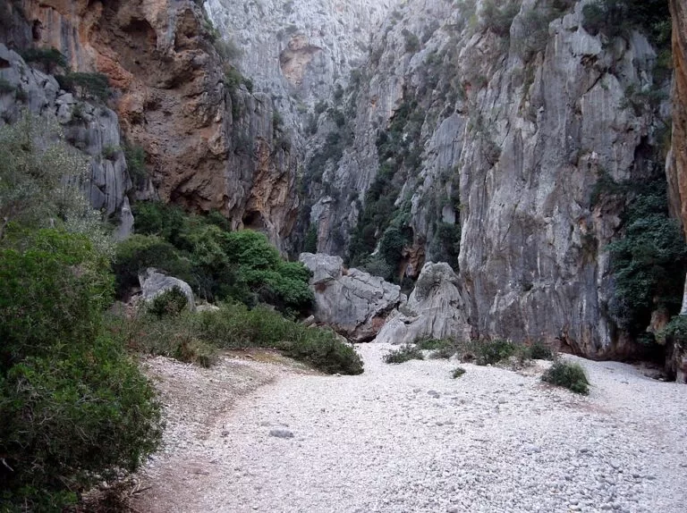
Quick facts
- Names: Torrent de Pareis in Catalan; Torrente de Pareis in Spanish.
- Where: Escorca, in the Serra de Tramuntana, north-west Mallorca (Balearic Islands). The gorge runs from s’Entreforc, where the Torrent de Lluc and the Torrent del Gorg Blau (Sa Fosca) meet, to the cove at Sa Calobra.
- Start coordinates: 39.8262, 2.8469 (trailhead by the Escorca bus stops on the Ma-10).
- Distance: about 6.3 km one way, measured on OpenStreetMap: 2.9 km from the Escorca trailhead down the camí des Burgar to s’Entreforc, then 3.4 km through the gorge to the tunnels above the beach at Sa Calobra. The gorge itself is about 3 km long (Balearic tourism agency).
- Time and total climb: we found no official figure we could open, so we do not give one. Plan on a full day.
- Grade: OpenStreetMap grades the approach path as mountain hiking and about 2 km of the gorge floor as demanding alpine hiking, with no visible path.
- Protection: declared a Natural Monument in 2003, together with the Gorg Blau and Lluc gorges.
- Entry: free; no permit is mentioned by the tourism agency.
Access and parking
Start at Escorca: the trailhead (39.8262, 2.8469) sits beside the Ma-10 mountain road at Escorca, between Lluc and Sóller. OpenStreetMap marks free street-side parking right at the trailhead, and two bus stops, Escorca 1 and Escorca 2, served by line 231 (Alcúdia–Port de Sóller). Check the current timetable with the Mallorca transport consortium (TIB); we could not confirm it.
Finish at Sa Calobra: you come out of the gorge on the beach, then walk through lit pedestrian tunnels to the small harbour of Sa Calobra (spain.info). Sa Calobra is reached by the Ma-2141 road or by boat from Port de Sóller (Balearic tourism agency). OpenStreetMap shows a paid car park for about 200 cars there, named Aparcament Sa Calobra Torrent de Pareis.
Getting back: this is a one-way walk, so plan the return before you set off. The options are a second car, a boat from Sa Calobra, or walking back up the gorge. We could not confirm boat timetables or a bus from Sa Calobra.
What to expect
From the trailhead, the camí des Burgar descends to s’Entreforc, the meeting point of the two gorges. OpenStreetMap maps it as a mountain path with a reasonably visible trail. At s’Entreforc the character changes. You are on the floor of a narrow canyon between high limestone walls, and the “path” is the riverbed. Expect large boulders to climb over and down, and stretches of loose pebbles, as in the photos below and above. OpenStreetMap’s “demanding alpine hiking” grade for this part means terrain where you will need your hands at times.
Lower down, the canyon opens out at l’Olla, where the bed widens and permanent pools stay all year (Catalan Wikipedia). The last stretch crosses the pebble beach at the mouth of the torrent, the platja del Torrent de Pareis.
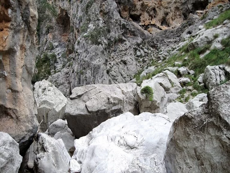
The gorge is a protected area for good reason. The Balearic tourism agency counts more than 300 plant species, among them the Mallorca rock violet, and wildlife from lizards and water snakes to wild pigeons. The best known resident is the ferreret, a tiny midwife toad found only in Mallorca.
Practical details
- Bring all your water and food. There is nothing between Escorca and Sa Calobra. Sa Calobra has restaurants and paid toilets (OpenStreetMap).
- Wear boots or approach shoes with good grip.
- Carry a rucksack so both hands stay free.
- Start early. You want daylight to spare at the bottom of a canyon with no way out but forward or back.
- Take all rubbish out with you: this is a protected Natural Monument.
- Tell someone your plan and the time you expect to reach Sa Calobra.
- For a short taste, walk from Sa Calobra through the tunnels to the mouth of the gorge.
Accessibility and safety
Not suitable for wheelchairs, pushchairs, dogs or young children. The gorge floor needs scrambling, with drops where you use your hands, and OpenStreetMap grades about 2 km of it as demanding alpine hiking with no visible path. Do not enter after rain or when rain is forecast: the bed can flood and wet rock is far more slippery. Spanish Wikipedia notes that the route’s difficulty and poorly prepared visitors make it the source of about a quarter of mountain rescues on the island. In an emergency, call 112.
Best time to visit
Spring and autumn are the usual hiking seasons in the Tramuntana, but only go in a settled, dry spell. In summer, start at first light and carry extra water. Avoid the days after heavy rain. In the first week of July an open-air choir and music concert is held in the gorge, using its natural acoustics (Balearic tourism agency); Catalan Wikipedia dates the tradition to 1963. spain.info rates the beach at Sa Calobra as highly occupied, so expect company at the finish.
Nearby alternatives
- Serra de Tramuntana, 10 km away: our guide to the mountain range the gorge cuts through.
- Palma Cathedral (La Seu), 33 km away: the island capital’s landmark.
- Sa Calobra, at the finish: the harbour, the lit tunnels and the beach at the mouth of the gorge, reached by the Ma-2141 or by boat.
- Lluc, east along the Ma-10: the Gorg Blau and Lluc gorges that feed the Torrent de Pareis are protected with it in the same Natural Monument.
Distances are in a straight line from the Escorca trailhead.
FAQ
How long is the Torrent de Pareis hike?
About 6.3 km one way from the Escorca trailhead to Sa Calobra, measured on OpenStreetMap: 2.9 km down to s’Entreforc and 3.4 km through the gorge. We found no official walking time we could check; plan on a full day.
How hard is the Torrent de Pareis?
Hard. The gorge floor is a boulder field with drops you climb down using your hands. OpenStreetMap grades about 2 km of it as demanding alpine hiking, and it accounts for many rescues on Mallorca.
How do I get back from Sa Calobra?
The walk ends at Sa Calobra, which is reached by the Ma-2141 road or by boat from Port de Sóller. Arrange the return before you start; we could not confirm a bus.
Is there parking for the Torrent de Pareis?
Yes. OpenStreetMap shows free street-side parking at the Escorca trailhead on the Ma-10 and a paid car park for about 200 cars at Sa Calobra.
Can I do the Torrent de Pareis after rain?
No. Wet rock is slippery and the bed can carry water. Wait for a dry spell.
Sources and freshness
Checked 6 November 2026 · 8 sources Show
Checked 6 November 2026. The Balearic government’s protected-areas pages (caib.es) and the Consell de Mallorca website could not be opened when we checked, so official time, height gain and access rules are not given. Gorge length, plants, wildlife, access and concert: Illes Balears tourism agency, Natural Monument Torrent de Pareis. Beach and tunnels: spain.info. Route line, distances, grades, parking, toilets and bus stops: OpenStreetMap, camí des Burgar, Escorca trailhead and Sa Calobra car park; all map data © OpenStreetMap contributors (ODbL). Background: Wikipedia in Catalan and Spanish (Natural Monument, l’Olla, rescues). Photos: Wikimedia Commons, licences as credited.
This place is part of our Balearic Islands travel guide: Mallorca, Menorca, Ibiza and Formentera — see every town, beach and cove we have mapped on that coast.
How this page is made. CostaMap is written with an AI editorial system run by Ebizapple. This page is based on the sources listed above. Last updated 6 November 2026. Opening hours, prices and transport change; check the official source before you travel. How we work · Partner links and ads