
Vía Verde del Mar (Benicàssim – Oropesa del Mar)
Hiking trailThe Vía Verde del Mar is a 5.7 km greenway on the old coastal railway between Benicàssim and Oropesa del Mar (Orpesa) in Castellón, and the regional tourist board rates it suitable for walkers, bikes and wheelchairs. You can start at either end: in Benicàssim at the site of the former station near the villas of the Voramar seafront, or in Oropesa halfway along the promenade of La Concha beach. Added to the 5 km bike lane through Benicàssim, the full trail is 11 km. It suits families, cyclists and anyone who wants sea views on a paved, mostly level path. Skip it if you want a mountain hike or real shade in July and August.
Quick facts
- Names: Vía Verde del Mar (“Greenway of the Sea”); in Valencian Via Verda Benicàssim–Orpesa, in Spanish also Vía Verde Benicàssim–Oropesa.
- Where: along the coast between Benicàssim and Oropesa del Mar, province of Castellón, Costa del Azahar.
- Start coordinates: 40.0568, 0.0882 (Benicàssim end, by the Voramar villas). Oropesa end: 40.0833, 0.1371, at La Concha beach.
- Distance: about 5.7 km one way on the greenway itself (OpenStreetMap and the regional tourist board, “almost 6 km”); 11 km if you add the bike trail through Benicàssim.
- Surface: paved or asphalt along its whole length (OpenStreetMap).
- Difficulty: easy. “Suitable for walkers, bikes and wheelchairs” (Turisme Comunitat Valenciana).
- Elevation and time: not published by the sources we could open. The line follows an old railway bed, so gradients are gentle.
- Entry: free; no ticket or booking.
- Part of: the EuroVelo 8 Mediterranean cycle route (OpenStreetMap).
Access and parking
Benicàssim end: the trail starts at the eastern end of the Voramar seafront, where the old railway station stood. OpenStreetMap shows a free 18-space car park right at the trailhead and two more free surface car parks 250–400 m away on the Voramar side. They are small, so arrive early in summer.
Oropesa end: the trail starts halfway along the promenade of La Concha beach (Platja de la Conxa). A free car park lies about 200 m from the start, and a paid one is close to the Oropesa tourist office on the promenade (OpenStreetMap).
Without a car: both towns have Renfe stations on the Valencia–Castellón–Vinaròs line. Oropesa station is about 1 km from the northern start; Benicàssim station is about 2.6 km from the southern start, and the bike lane through Benicàssim covers that gap. The Voramar bus stop is about 280 m from the Benicàssim trailhead (OpenStreetMap). Check current timetables with Renfe before you go.
What to expect
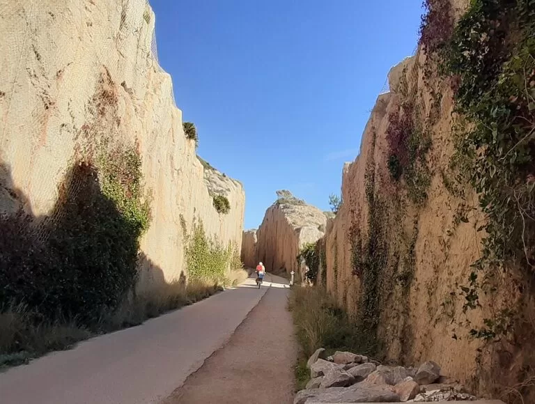
The greenway runs on the bed of the old railway that linked the two seaside towns. The regional tourist board describes a wild and rugged stretch of coast, where the Sierra de Oropesa drops to the sea. The railway left its mark: deep cuttings, “a long illuminated tunnel, two false tunnels and a metal bridge”. On OpenStreetMap the main tunnel, near the Oropesa end, is about 550 m long, and the bridge is the Pont dels Biscaïns.
From the Oropesa side you first see the Iberian site of Orpesa la Vella, El Retor cove and the marina, then pass through the tunnel to La Dona gorge. Further south you pass the watchtowers of La Corda, Colomera and Bellver, the Bellver plains and a string of coves. There are resting areas along the way (Turisme Comunitat Valenciana).
The tourist board names La Renegà as “one of the wildest coves along the Castellón coastline” and suggests a swim there. It is a natural cove, not a resort beach, so bring water shoes.
Walkers and cyclists share the path. If you walk one way, you can return by train between the two towns (see Access).
Practical details
- Water and toilets: OpenStreetMap shows drinking water taps and public toilets near both ends (Voramar in Benicàssim, La Concha in Oropesa), but none along the middle section. Carry water.
- Shade: the line follows the cliffs and is mostly open. In summer, go early or late.
- Lighting: the long tunnel is lit (tourist board); the rest of the path is not lit at night (OpenStreetMap).
- Bikes: the tourist board lists an “Educabike” guided group ride on this route, for groups of 25 to 50 people.
- Downloads: the route page has a GPX and KML track you can download.
Accessibility and safety
The regional tourist board lists the trail as suitable for wheelchairs, and the surface is paved throughout. We could not confirm the gradient at each access point, so check the ends you plan to use. Watch for bikes, keep to your lane and keep children close near the cliff edges and in the tunnel. The coves are unsupervised: there are no lifeguards along the greenway.
Best time to visit
Spring and autumn are the most comfortable seasons for this open, sunny path. In summer, start early in the morning, or walk it in the late afternoon and end with a swim.
Nearby alternatives
- Benicàssim, 2 km away: the beach town at the southern end, with its Voramar villas and long beaches.
- Oropesa del Mar, 6 km away: the town at the northern end, with La Concha beach and the marina.
- Desert de les Palmes Natural Park, 5 km away: hills behind Benicàssim with hiking trails and castle ruins.
- Aquarama Water Park, 3.3 km away: the water park in Benicàssim, for a family day after the walk.
- Serra d’Irta, 38 km away: the protected coastal hills further north, near Alcossebre and Peñíscola.
Distances are in a straight line from the Benicàssim trailhead.
FAQ
How long is the Vía Verde del Mar?
About 5.7 km one way between Benicàssim and Oropesa del Mar. With the bike lane through Benicàssim, the trail is 11 km.
Where does the Vía Verde del Mar start?
In Benicàssim, at the site of the old railway station by the Voramar villas (40.0568, 0.0882). In Oropesa del Mar, it starts halfway along the La Concha beach promenade.
Is there parking at the Vía Verde del Mar?
Yes. There is a free 18-space car park at the Benicàssim trailhead, with more free car parks close by. In Oropesa, a free car park lies about 200 m from the start.
Can you do the Vía Verde del Mar with a wheelchair or pushchair?
The regional tourist board lists it as suitable for walkers, bikes and wheelchairs, and the path is paved all the way.
Can you swim along the route?
Yes. The tourist board suggests La Renegà cove, which you pass on the way. There are no lifeguards on the coves along the greenway.
Sources and freshness
Checked 6 November 2026 · 5 sources Show
Checked 6 November 2026. Official: Turisme Comunitat Valenciana, Vía Verde del Mar route page (11 km and almost 6 km, suitability, towers, tunnel, La Renegà, GPX), Vía Verde Benicasim–Oropesa del Mar: a great family day out (start points, sights along the route), Benicàssim and Educabike Vía Verde del Mar. The Benicàssim and Oropesa town hall websites could not be reached from our checker. Route, distance, surface, tunnel, parking, stations, bus stops and distances: OpenStreetMap contributors (ODbL). Photos: Wikimedia Commons, licences as credited.
This place is part of our Costa del Azahar travel guide: map, beaches, camping and the Castellón coast — see every town, beach and cove we have mapped on that coast.
How this page is made. CostaMap is written with an AI editorial system run by Ebizapple. This page is based on the sources listed above. Last updated 6 November 2026. Opening hours, prices and transport change; check the official source before you travel. How we work · Partner links and ads