
Monte Santa Trega is the 341 m hill above A Guarda, in the far south-west corner of Galicia, where the Miño river meets the Atlantic and Portugal lies across the water. On its slopes is the Castro de Santa Trega, the excavated remains of a hill-fort village of round stone houses that held about 5,000 people in the first century BC, and at the top are a chapel, viewpoints and the MASAT archaeological museum. A road climbs from A Guarda to the summit, with free car parks at the top. It suits anyone interested in Iron Age Galicia or big views; skip it on a day of low cloud, when you will see little.
Quick facts
- Names: Monte Santa Trega in Galician (also written Santa Tegra); Monte de Santa Tecla in Castilian. The site is the Castro de Santa Trega; the museum is the MASAT (Museo Arqueolóxico de Santa Trega).
- Where: A Guarda (Pontevedra), above the mouth of the Miño on the border with Portugal.
- Coordinates: 41.8926, -8.8695 (the excavated area of the castro).
- Height: 341 m (turismo.gal).
- Population at its peak: about 5,000 in the first century BC, one of the largest settlements in north-west Iberia (turismo.gal).
- Protection: the settlement was declared a Historic-Artistic Monument in 1931 and the museum building, by architect Antonio Palacios, in 1962; the area is a Site of Cultural Interest (Turismo Rías Baixas).
- Distance from A Guarda port: about 1.3 km in a straight line to the summit; the road is longer.
Access and parking
By car: the Estrada ao Monte Trega climbs from A Guarda to the summit. OpenStreetMap marks a toll point named “Castro de Santa Trega” on the road, about 1 km below the summit, and a free car park at the top next to the museum, plus a bus parking area just below it (OpenStreetMap). We could not confirm from an official source whether an access charge is collected now, or how much it is; bring some cash in euros.
On foot: OpenStreetMap shows a line of stone wayside crosses climbing the last stretch to the summit chapel, and marked walking routes on the hill. From the town it is a steep climb of more than 300 m.
By public transport: we found no bus to the summit; A Guarda town is the nearest stop.
What to expect
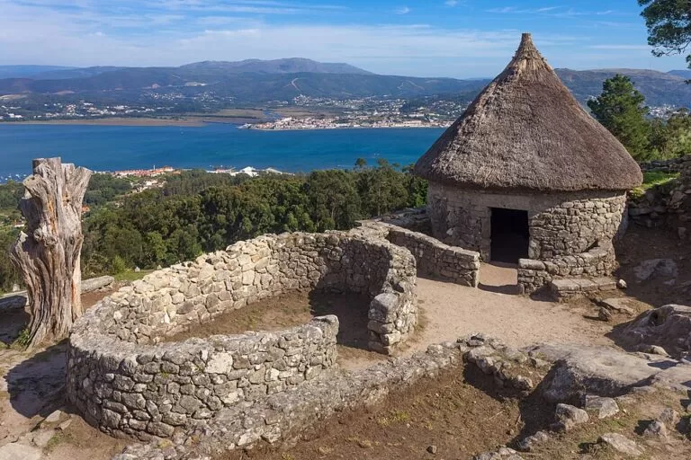
The castro. Most houses are oval, but some are rectangular with rounded corners, a sign of Roman influence. The layout looks chaotic at first, but follows “family units” of houses and stores round small yards. You can also find rock carvings inside and outside the walls. The site was chosen not for the view but to watch and control shipping and the whole mouth of the Miño (turismo.gal). Two houses beside the road were rebuilt with thatched roofs in 1965 and 1972; archaeologists question how faithful they are, but they have become the best-known image of the site (Galician Wikipedia). Only part of the settlement has been excavated, mainly the northern area dug in the 1980s and some structures near the top.
The museum. The MASAT, on the summit, shows finds from several excavations of the settlement, which was found in 1913, from the Palaeolithic through the castro and Roman periods (Turismo Rías Baixas). We could not confirm its current hours or price.
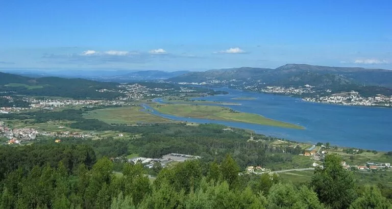
The viewpoints. Turismo.gal calls it “the best panoramic view of a Celtic hill fort in two countries”: A Guarda and its fishing harbour below, the Atlantic, and the Portuguese coast across the Miño. OpenStreetMap maps several viewpoints, among them the Miradoiro de San Francisco at the top, next to the Santa Trega chapel and a group of telecom masts.
Practical details
- Toilets: free public toilets at the summit car park (OpenStreetMap).
- Food: there is a hotel and restaurant at the summit, and OpenStreetMap shows several restaurants around the harbour in A Guarda. Lobster has its own festival in A Guarda at the start of July (turismo.gal).
- Picnics: OpenStreetMap shows picnic areas on the hill.
- Festival: the Festa do Monte is held on the hill in August (Spanish Wikipedia).
Accessibility and safety
The summit car park, chapel, museum and main viewpoint are close together. The castro itself is on a steep slope, with rough paths, steps and loose stone between the house walls, so it is hard going with a pushchair or wheelchair; we could not confirm a step-free route. Do not climb on the walls. In wind or rain the exposed top gets cold quickly.
Best time to visit
Pick a clear day; the view is the point. Late afternoon light suits the castro and the sunset over the Atlantic, and turismo.gal suggests ending the day by the harbour in A Guarda. In August the Festa do Monte brings crowds to the hill.
Nearby alternatives
- Baiona, 26 km north: the walled port with the Monterreal fortress and the La Pinta replica, built in A Guarda.
- Cíes Islands, 37 km north: the national park islands reached by boat from Vigo, Cangas, Baiona or O Grove.
Distances are in a straight line from the summit.
FAQ
Can you drive to the top of Monte Santa Trega?
Yes. A road climbs from A Guarda to the summit, where there is a free car park by the museum and chapel. OpenStreetMap marks a toll point on the way up; we could not confirm the current charge.
How old is the Castro de Santa Trega?
It was at its peak in the first century BC, with about 5,000 people. Rock carvings on the hill are much older.
What can you see from Santa Trega?
The mouth of the Miño, the Atlantic, the town of A Guarda and the Portuguese coast across the river.
Is there a museum on Santa Trega?
Yes, the MASAT on the summit shows finds from the excavations. Check hours locally.
How long do you need?
Allow time for the castro, the museum and the viewpoints; with the drive up from A Guarda, half a day is comfortable.
Sources and freshness
Checked 6 November 2026 · 6 sources Show
Checked 6 November 2026. Official: turismo.gal, Celtic hill fort and village of Santa Trega (height, population, layout, views, lobster festival); Turismo Rías Baixas, Santa Trega archaeological museum (collection, protection). Background: Wikipedia in English, Galician and Spanish (excavations, rebuilt houses, Festa do Monte). Road, toll point, car parks, toilets, viewpoints and distances: OpenStreetMap contributors (ODbL). The town hall and Xunta museum pages could not be reached. Photos: Wikimedia Commons, licences as credited.
How this page is made. CostaMap is written with an AI editorial system run by Ebizapple. This page is based on the sources listed above. Last updated 6 November 2026. Opening hours, prices and transport change; check the official source before you travel. How we work · Partner links and ads