
Ons Island (Illa de Ons) closes the mouth of the Ría de Pontevedra and is part of the Atlantic Islands of Galicia National Park; you get there by passenger boat from Sanxenxo, Portonovo, Bueu, Marín or Vilanova de Arousa. At Easter and from 15 May to 15 September you need a free Xunta de Galicia authorisation before you buy the boat ticket, and day visitors are capped at 1,300. Unlike the Cíes, Ons is still lived on: it has a small village with bars, a campsite and paths to the lighthouse, the Buraco do Inferno sea cave and quiet beaches. It suits walkers and people who want a calmer island day; skip it if you need a car or a resort beach.
Quick facts
- Names: Ons Island in English, Illa de Ons in Galician, Isla de Ons in Castilian. The archipelago also includes the smaller island of Onza (Onceta) and the islet of As Freitosas.
- Where: at the mouth of the Ría de Pontevedra, in the municipality of Bueu (Pontevedra). The nearest mainland point, in Sanxenxo, is about 3.8 km away.
- Coordinates: 42.3768, -8.9319 (O Curro, by the pier).
- Size: 470 ha of land and 2,171 ha of sea inside the park (MITECO). The island is about 6 km long and 1.5 km wide.
- Protection: national park since 2002; bird protection area (ZEPA) since 2001.
- Daily cap at Easter and 15 May–15 September: 1,300 visitors, plus places for campers and for islanders and their families (Xunta).
- Visitors: 142,309 in 2025 (Xunta).
- People: the only island in the national park that is still lived on (turismo.gal).
Access and booking
Step 1, the authorisation: at Easter and from 15 May to 15 September you need a free, personal Xunta de Galicia authorisation with a QR code. It becomes valid once you buy a boat ticket, and is then sent to you by email (Xunta de Galicia). The Rías Baixas tourist board gives the form’s address as autorizacionillasatlanticas.xunta.gal (Turismo Rías Baixas).
Step 2, the boat: buy a ticket with one of the licensed companies. The tourist board lists departures from Sanxenxo, Portonovo, Bueu and Vilanova de Arousa; turismo.gal also lists Marín. Tickets carry a fixed return date and time, and there is no regular boat between Ons and the Cíes. We do not give fares or timetables: they vary by operator and season.
Parking: visitors cannot take cars to the island. Park at your departure port; we could not confirm parking rules at each harbour.
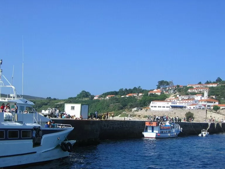
Arriving: boats land at the pier below O Curro, the main hamlet. The beach of Area dos Cans is about 450 m south, the lighthouse about 800 m north-west, Melide beach about 1.4 km north and the Buraco do Inferno about 2.3 km south, all in a straight line (OpenStreetMap). Walking distances are longer.
What to expect
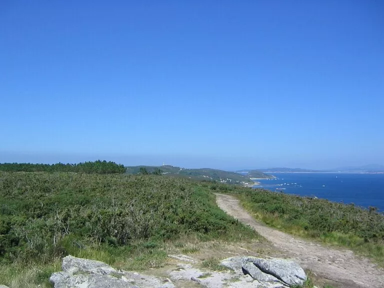
The side facing the ría is low, with the beaches and the hamlets. The side facing the open sea is cliff, cut by sea caves known as furnas. From the pier you reach the beach and village of O Curro, the start of several walks. You can climb to the lighthouse viewpoint through the islanders’ houses, head north to the beach of Melide, or go south past the Buraco do Inferno to the Fedorentos viewpoint (turismo.gal).
The Buraco do Inferno (“hell’s hole”) is a pit-shaped sea cave more than 30 m deep. Legend says you can hear the souls of the damned in it, and on stormy days the sea booms at the bottom. Fedorentos looks over Onza towards the Cíes. In the north, the point of O Centolo looks across to A Lanzada beach and, at sunset, to Sálvora (Turismo Rías Baixas).
The tourist board lists five main beaches. Melide, in the north, is the largest and is used for nudism. As Dornas is next to the pier. Area dos Cans is the busiest; at low tide you can reach A Laxe do Crego, a rock with a grave cut in the shape of a body. Canexol and Pereiró are further south. The village has fishermen’s houses, granaries (hórreos) and the church of San Xaquín. Octopus “á illa” (island style) is the local dish (turismo.gal).
Practical details
- Staying over: you can stay in one of the island’s lodgings or at the camping area (Turismo Rías Baixas). Campers have places reserved outside the day quota (Xunta).
- Food: OpenStreetMap shows several restaurants and bars around O Curro and a café at the campsite. We could not confirm opening dates outside summer.
- Information: the Ons visitor centre is in O Curro, near the church (OpenStreetMap). The park office is in Vigo (Rúa Oliva 3; phone 886 218 090).
- Water and toilets: there is a fountain at the O Curro beach, marked as not health-guaranteed, and toilets and showers at the campsite (OpenStreetMap).
- Rubbish: take your cans and packaging back with you, as the park asks.
- Birds: every island has breeding areas for sea birds that are closed to visitors (turismo.gal).
Accessibility and safety
The village and the pier area are compact, and the visitor centre is tagged as wheelchair accessible on OpenStreetMap. Beyond the village, the routes are tracks and paths over hills up to about 128 m. The Buraco do Inferno is a sea cave at the cliff edge: stay on the path and keep children close. The west coast is open Atlantic. We could not confirm lifeguard service on any of the beaches.
Best time to visit
The high season runs from 15 May to 15 September, with the daily cap and regular boats. Across the national park, August is the busiest month, followed by July and June (Xunta, January 2026). Late May, June and early September are calmer. Outside summer the park runs free guided visits; check boats with the operators first, as regular service is a high-season one (turismo.gal).
Nearby alternatives
- Cíes Islands, 17 km south: the other island group of the park with a summer permit, known for Praia de Rodas.
- Combarro (Poio), 19 km east: the fishing village on the Ría de Pontevedra with its rows of granaries by the sea.
- Pontevedra Old Town, 24 km east: the granite old centre of the provincial capital, at the head of the same ría.
Distances are in a straight line from the Ons pier.
FAQ
Do you need a permit to visit Ons Island?
Yes, at Easter and from 15 May to 15 September. Get the free Xunta authorisation online, then buy a boat ticket from a licensed company.
How do I get to Ons Island?
By passenger boat from Sanxenxo, Portonovo, Bueu, Marín or Vilanova de Arousa. Boats land at the pier below O Curro.
Can you stay overnight on Ons?
Yes. The island has lodgings and a camping area, and campers have their own places outside the day quota.
What is the Buraco do Inferno?
A pit-shaped sea cave more than 30 m deep in the south of the island, on the way to the Fedorentos viewpoint, about 2.3 km from the pier in a straight line.
Is Ons or the Cíes better?
The Cíes have the famous Praia de Rodas and more visitors (323,357 against 142,309 in 2025). Ons has a lived-in village, more places to eat and fewer people.
Sources and freshness
Checked 6 November 2026 · 5 sources Show
Checked 6 November 2026. Official:
- Turismo Rías Baixas, Ons Island
- turismo.gal, Atlantic Islands National Park
- Xunta de Galicia on high season, authorisation and quotas (May 2022)
- Xunta visitor figures for 2025 (January 2026)
- MITECO national park technical sheet. Background (length, width, highest point, distance to the mainland): Wikipedia in English and Spanish. Pier, beaches, services and distances: OpenStreetMap contributors (ODbL). Photos: Wikimedia Commons, licences as credited
How this page is made. CostaMap is written with an AI editorial system run by Ebizapple. This page is based on the sources listed above. Last updated 6 November 2026. Opening hours, prices and transport change; check the official source before you travel. How we work · Partner links and ads