
The Cíes Islands (Illas Cíes) are three granite islands at the mouth of the Ría de Vigo, part of the Atlantic Islands of Galicia National Park, and you reach them only by boat from Vigo, Cangas, Baiona or O Grove. At Easter and from 15 May to 15 September you need a free Xunta de Galicia authorisation before you can buy a ferry ticket, and numbers are capped each day. Most visitors come for Praia de Rodas, the long white beach that joins two of the islands, and for the paths up to the lighthouses. It suits walkers, birdwatchers and beach-goers who plan ahead; skip it if you want a beach you can drive to on a whim.

Quick facts
- Names: Cíes Islands in English, Illas Cíes in Galician, Islas Cíes in Castilian. The three islands are Monteagudo (north), do Faro (middle) and San Martiño (south).
- Where: at the mouth of the Ría de Vigo, in the municipality of Vigo (Pontevedra). The Cíes pier is about 14 km in a straight line from Vigo’s harbour.
- Coordinates: 42.2220, -8.9037 (Praia de Rodas).
- Protection: part of the Atlantic Islands of Galicia Maritime-Terrestrial National Park, declared on 1 July 2002; bird protection area (ZEPA) since 1988.
- Size: 433 ha of land and 2,658 ha of sea inside the park (MITECO).
- Daily cap in high season: 1,800 visitors, with extra places for campers (Xunta, 2022). The regional portal turismo.gal quotes 2,200; we use the Xunta figure.
- Visitors: 323,357 in 2025, about two thirds of all visits to the national park (Xunta).
- Entry: the authorisation is free; you pay only for the boat.
Access and booking
Step 1, the authorisation: at Easter and from 15 May to 15 September, everyone sailing to the Cíes needs an authorisation from the Xunta de Galicia. It is free, personal and non-transferable, carries a QR code and is requested online (Xunta de Galicia). The Rías Baixas tourist board gives the form’s address as autorizacionillasatlanticas.xunta.gal (Turismo Rías Baixas).
Step 2, the boat: with the authorisation you buy a ticket from one of the licensed ferry companies. The authorisation is confirmed and emailed to you once the ticket is bought. Tickets carry a fixed return date and time (turismo.gal). Boats leave from Vigo, Cangas, Baiona and O Grove, according to the Rías Baixas tourist board. We do not list fares: they vary by operator and port.
Parking: there are no cars for visitors on the islands. Park near your departure port in Vigo, Cangas, Baiona or O Grove; we could not confirm parking rules at each port.
Arriving: boats tie up at the pier on Monteagudo. Praia de Rodas starts about 600 m away, and the Monte Faro lighthouse is about 1.9 km away as the crow flies (OpenStreetMap).
What to expect
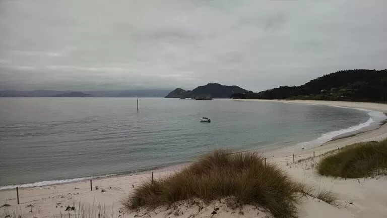
Monteagudo and do Faro are joined by Praia de Rodas, about 1.2 km of fine pale sand, and by a stone bridge. Behind the beach the tide fills a lagoon, the Lagoa dos Nenos. San Martiño, the south island, is cut off by a channel called the Freu da Porta (turismo.gal). In 2007 The Guardian named Rodas the best beach in the world, and the tourist boards still quote it.
The east side of the islands is gentler and wooded, with the beaches and dunes. The west side faces the open Atlantic with cliffs of more than 100 m. Other beaches near the pier include Figueiras on Monteagudo, where nudism is common, and Nosa Señora on do Faro, which looks across to San Martiño (Turismo Rías Baixas).
Walking is the other big draw. From the Rodas pier, paths lead to each of the islands’ lighthouses. They are of medium difficulty, with steep stretches that feel hard on hot days. The best-known walk is the zigzag climb to Monte Faro: about 7 km there and back from the pier. It passes bird hides and A Campá, a rock window, where around 22,000 pairs of yellow-legged gulls nest and the noise in the breeding season is loud (turismo.gal).
Practical details
- Rubbish: take your cans and packaging back to the mainland with you, as the park asks.
- Food and water: OpenStreetMap shows a restaurant near the pier, a restaurant at the campsite and several free drinking-water fountains around the campsite. We could not confirm opening dates, so bring food and water.
- Toilets: mapped by the campsite, behind Praia de Rodas.
- Camping: the islands have a campsite behind Rodas. The Xunta reserves places for campers on top of the general day quota; book the pitch with the campsite and still get the authorisation.
- Information: a Xunta information point stands above the pier, and a visitor centre lies further south on the main path. The park’s head office is in the Edificio Cambón, Rúa Oliva 3, in Vigo’s old town; phone 886 218 090 (MITECO).
- Nature rules: sea-bird breeding areas are set aside on every island and visitors must keep out of them (turismo.gal).
Accessibility and safety
The Rodas pier was fully repaired in spring 2026 after winter storm damage. The Xunta also planned urgent work on the wooden boardwalk from the pier to the beach before summer 2026, with a full renewal after the summer (Xunta, March 2026). The beach is close to the pier. The lighthouse paths are steep in places and largely unshaded. The information point is tagged as wheelchair accessible on OpenStreetMap; we could not confirm step-free access elsewhere. The water is cold even in summer, and we could not confirm lifeguard hours from an official page.
Best time to visit
High season runs from 15 May to 15 September, when regular boats run and the daily cap applies. In 2025 August was the busiest month with 163,654 visitors to the national park, followed by July and June. Visits also grew at Easter and in May, June and October (Xunta, January 2026). For space on the beach, aim for late May, June or early September on a weekday. Regular passenger boats run in high season only (turismo.gal). Outside summer the park offers free guided visits, so ask the park office.
Nearby alternatives
CostaMap’s Galicia guides are new and still being added. Other places worth combining with the Cíes:
- Ons Island, the other island group of the national park with a summer quota, sits about 17 km north at the mouth of the Ría de Pontevedra.
- Baiona, one of the ports with boats to the Cíes, is about 13 km south-east across the water.
Distances are in a straight line from Praia de Rodas.
FAQ
Do you need a permit to visit the Cíes Islands?
Yes, at Easter and from 15 May to 15 September. Get the free Xunta de Galicia authorisation online first, then buy a ferry ticket with a licensed operator.
How do I get to the Cíes Islands?
By boat only. Ferries leave from Vigo, Cangas, Baiona and O Grove and land at the pier on Monteagudo, about 600 m from Praia de Rodas.
How many people can visit the Cíes per day?
In high season the cap is 1,800 people a day, plus campers, according to the Xunta. One official tourism page quotes 2,200.
Can you stay overnight on the Cíes Islands?
Yes, at the campsite behind Praia de Rodas. Campers have their own places outside the day quota.
Is Praia de Rodas good for swimming?
Rodas faces the sheltered ría side and the water is clear, but it is cold Atlantic water. We could not confirm lifeguard hours.
Sources and freshness
Checked 6 November 2026 · 4 sources Show
Checked 6 November 2026. Official:
- Xunta de Galicia on high season, authorisation and quotas (May 2022), Xunta on the Rodas pier and boardwalk (March 2026), Xunta visitor figures for 2025 (January 2026)
- MITECO national park technical sheet
- turismo.gal, Atlantic Islands National Park
- Turismo Rías Baixas, Cíes Islands. Background (beach length, cliffs, Guardian award year): Wikipedia. Location, pier, campsite, fountains and distances: OpenStreetMap contributors (ODbL). Photos: Wikimedia Commons, licences as credited
How this page is made. CostaMap is written with an AI editorial system run by Ebizapple. This page is based on the sources listed above. Last updated 6 November 2026. Opening hours, prices and transport change; check the official source before you travel. How we work · Partner links and ads