
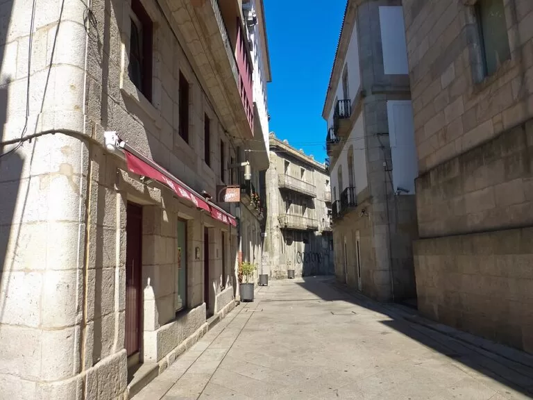
Vigo’s old town (Casco Vello, or Cidade Vella) is the compact quarter of granite streets between the port and the Monte do Castro, the wooded hill in the city centre topped by a 17th-century fortress and the remains of an Iron Age settlement. Both are free and close together: the old town sits right by the ferry terminal, and the Castro is about 800 m south of Praza da Constitución. Come for oysters in A Pedra, the arcades of O Berbés and the sunset over the ría and the Cíes Islands from the top of the hill. It suits city walkers and food lovers; skip it if steep streets are a problem.
Quick facts
- Names: Casco Vello or Cidade Vella in Galician, Casco Viejo in Castilian; the hill is the Monte do Castro (O Castro) and its fort the Fortaleza do Castro.
- Where: central Vigo (Pontevedra), on the south shore of the Ría de Vigo. Vigo is Galicia’s largest city (turismo.gal).
- Coordinates: 42.2386, -8.7261 (Praza da Constitución).
- Status: the old quarter has Tourist-Historical Interest status (spain.info).
- O Castro: remains of a hill-fort settlement from the third century BC to the second century AD, and of a fortress begun in the 1660s (turismo.gal; Galician Wikipedia).
- Entry: free. OpenStreetMap lists the fortress gardens as open 08:00–23:00 from June to September and 08:00–21:00 from October to May; we could not confirm this with the city.
Access and parking
On foot: the old town starts at the port. The Estación Marítima de Ría, where boats leave for Cangas, Moaña and the Cíes Islands, is about 250 m from Praza da Constitución (spain.info; OpenStreetMap). From the old town, the Subida ó Castelo steps lead up past the Castelo de San Sebastián towards the Castro.
Parking: OpenStreetMap shows several paid underground car parks around the old town, including A Laxe by the port and Praza da Estrela and Areal to the east, and a free surface car park on the southern side of the Monte do Castro, near the Martín Códax monument. Many old-town streets and squares are pedestrian. We could not confirm current prices.
Information: there is a Xunta tourist office and a city tourist office near the port, by the Estación Marítima (OpenStreetMap).
What to see
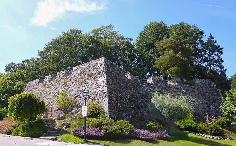
Monte do Castro. The official city route starts here, at the roots of Vigo: the remains of the hill-fort settlement, the remnants of the 17th-century fortress, a monument to the medieval troubadour Martín Códax and anchors in memory of the Battle of Rande (1702). The hill looks over the city, the ría and the Cíes Islands, and turismo.gal calls it the best photo spot in Vigo, especially at sunset (turismo.gal). Spain.info adds the ruins of the 10th-century O Penso castle under the later fort. The fort was built from 1665, during the war with Portugal. On 28 March 1809 the people of Vigo took it back from Napoleon’s troops. Today it is laid out as gardens with a botanical route, sculptures and a viewpoint, and it holds a memorial to 136 men killed there under Franco (Galician Wikipedia).
The old town route. From the Castro, the official route goes down to Praza do Rei and the town hall, then along the Paseo de Alfonso XII, a viewpoint over the port lined with olive trees, the city’s symbol. Rúas Poboadores and Anguía lead to O Berbés, the old fishermen’s quarter, which keeps some of its arcaded houses; before the fishing port was built, the sea reached the arcades. Nearby is the fish market, where the auction runs between four and five in the morning. Rúa Teófilo Llorente leads into Praza da Pedra, where oyster sellers open oysters for passers-by. Rúa Oliva climbs to the Collegiate Church of Santa María, Vigo’s co-cathedral, a neoclassical building holding the much-venerated Cristo da Victoria; it stands on the site of a Gothic church burned by Francis Drake (spain.info). Praza de Almeida has the 15th-century Casa Ceta and the 16th-century Casa Pazos Figueroa. The route ends at Porta do Sol, with Francisco Leiro’s sculpture O Sireno and the Simeón building of 1911.
Practical details
- Food: turismo.gal names the old town between Praza da Constitución and the port as one of the best places in Vigo to eat, with A Pedra (Rúa Pescadería) for oysters and shellfish eaten on the spot.
- Toilets: OpenStreetMap shows public toilets near the port and a free one on the Monte do Castro.
- Café: a café-bar sits by the car park at the top of the Castro (OpenStreetMap).
- Cíes connection: the Atlantic Islands National Park office is in the Edificio Cambón, Rúa Oliva 3, in the old town (MITECO).
Accessibility and safety
The old town is built on a slope, with steep streets and steps linking the port to the upper squares, and paved granite that gets slippery in rain. The climb from the old town to the Castro is uphill all the way; drivers can use the car park near the top. We could not confirm a step-free route to the viewpoint. The fish auction is in the early hours of the morning, inside a working port area.
Best time to visit
Go up the Castro for sunset, as the tourist board suggests. Two old-town festivals are worth timing: the Reconquista, on 28 March in Praza da Constitución, marking the 1809 rising against French troops, and the Cristo da Victoria procession on the first Sunday in August, which opens Vigo’s Semana Grande (turismo.gal).
Nearby alternatives
- Cíes Islands, 15 km west: boats from the Estación Marítima in high season, with a free Xunta permit.
- Baiona, 17 km south-west: the walled port with the Monterreal fortress and the La Pinta replica.
- Sanxenxo and Praia de Silgar, 19 km north: the resort town on the Ría de Pontevedra.
- Combarro (Poio), 22 km north: the fishing village with granaries by the sea.
- Pontevedra Old Town, 23 km north-east: the granite old centre of the provincial capital.
Distances are in a straight line from Praza da Constitución.
FAQ
Is the Monte do Castro in Vigo free?
Yes. The park and the fortress gardens are free. OpenStreetMap gives opening hours of 08:00–23:00 in summer and 08:00–21:00 the rest of the year.
How do I get from Vigo old town to O Castro?
Walk uphill about 800 m from Praza da Constitución, via the Subida ó Castelo steps and the Castelo de San Sebastián, or drive to the car park near the top.
Where can you eat oysters in Vigo?
In A Pedra, on Rúa Pescadería in the old town, where oyster sellers open them for you to eat on the spot.
Is there parking near Vigo old town?
Yes, several paid underground car parks around the old town and the port, and a free car park on the Monte do Castro.
Can I go to the Cíes Islands from Vigo old town?
Yes. Boats leave from the Estación Marítima next to the old town. In high season get the free Xunta authorisation first.
Sources and freshness
Checked 6 November 2026 · 4 sources Show
Checked 6 November 2026. Official:
- turismo.gal, Vigo (city route, O Castro, food, festivals)
- turismo.gal, Soportais do Berbés
- spain.info, Vigo (old quarter status, Santa María, O Penso castle, maritime station)
- MITECO, park office. Background: Galician Wikipedia, Fortaleza do Castro (1665 works, 1809, memorial, gardens). Car parks, opening hours, toilets, tourist offices and distances: OpenStreetMap contributors (ODbL). The city tourism site turismodevigo.org could not be reached. Photos: Wikimedia Commons, licences as credited
How this page is made. CostaMap is written with an AI editorial system run by Ebizapple. This page is based on the sources listed above. Last updated 6 November 2026. Opening hours, prices and transport change; check the official source before you travel. How we work · Partner links and ads