
Ézaro Waterfall (Fervenza do Ézaro, Dumbría)
ViewpointThe Ézaro waterfall (Fervenza do Ézaro) is where the river Xallas drops about 40 m down a granite gorge at the foot of Monte Pindo and runs straight into the sea, in the village of Ézaro (Dumbría), on the Costa da Morte about 13 km east of Cape Finisterre. You park by the village and walk a short riverside path to viewing platforms below the falls, or drive a very steep road up to the Miradoiro do Ézaro viewpoint above. The flow is controlled by dams upstream, so what you see depends on how much water is being released. It suits anyone touring the Costa da Morte and families who want a short, easy walk; skip it if you are expecting a wild, untouched river, because a hydroelectric plant sits at the bottom.
Quick facts
- Names: Ézaro waterfall in English; Fervenza do Ézaro in Galician; Cascada del Ézaro or Cascada del Xallas in Castilian. Locals also call it O Cadoiro.
- Where: Santa Uxía do Ézaro, municipality of Dumbría (A Coruña), at the mouth of the river Xallas. About 10 km north of Carnota beach.
- Coordinates: 42.9129, -9.1164.
- The fall: about 40 m, at the end of a 155 m drop over the river’s last stretch (Turismo de Galicia; Galician Wikipedia).
- Above it: Monte Pindo, 627 m according to Turismo de Galicia.
- Protection: part of the Carnota – Monte Pindo area, a special area of conservation in the Natura 2000 network.
- Entry: free; the path and viewpoints are open-air.
Access and parking
By car: Ézaro lies on the coast at the north foot of Monte Pindo. OpenStreetMap shows several parking areas and street parking in the village, 480–620 m west of the falls, near the municipal tourist office. From there a riverside path with a string of viewpoints leads east along the water to the foot of the falls.
The upper viewpoint: the Miradoiro do Ézaro sits on the hill about 400 m north of the falls. It is reached by the DP-2308, signposted “Subida ao Miradoiro do Ézaro”. OpenStreetMap tags this road with a 30% gradient and closes it to tourist coaches; there is a small parking area at the top. Drive it only in a car you are confident with on a very steep hill, or walk.
Without a car: we could not confirm a bus service to Ézaro. Plan on a car or a taxi from Cee or Fisterra.
What to expect
Turismo de Galicia describes the Xallas plunging into the sea from 40 m at the foot of Monte Pindo, the granite mountain it calls the “Celtic Olympus” of Galicia (Turismo de Galicia). Galician Wikipedia calls it one of the few waterfalls in Europe that fall directly into the ocean. In practice the falls end in a pool and a short tidal river mouth, which meets the bay of Ézaro.
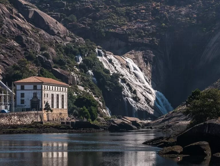
The river is heavily dammed. Galician Wikipedia lists the Fervenza reservoir, built in the 1960s, the Santa Uxía reservoir from the 1980s, and three power stations near the mouth: Castrelo, Santa Uxía and Pindo. The old white building of the Castrelo station stands right beside the falls, as in the photo above.
That control explains the history of the visits. Until 2012, according to Galician Wikipedia, water was released only at midday on summer Sundays, with a night show with lights on summer Saturdays added in 2006; since 2012 the falls can be seen every day of the year. Turismo de Galicia’s own page still says the full flow is seen in the tourist season, when the sluices are opened. Spanish Wikipedia says a minimum ecological flow now runs all year and that winter, the rainiest season, is the best time. We could not get a current release schedule from the Dumbría council.
Around the falls, the granite of Monte Pindo forms bare domes and boulders. Galician Wikipedia mentions rare plants here, such as the dwarf oak Quercus lusitanica, and otters on the river. A forest fire in September 2013 burned about 1,000 hectares of the mountain.
Practical details
- Tourist office and toilets: OpenStreetMap shows the Dumbría municipal tourist office by the parking areas, about 600 m from the falls, with free public toilets beside it, tagged wheelchair-accessible.
- The path: a riverside walkway with at least six viewing points runs from near the Novo Pindo power station towards the falls. The closest viewpoint is about 75 m from the water’s drop.
- Night lights: OpenStreetMap mappers record a light show on summer Saturday nights (June–August, from 22:00). This is not from an official source; check locally before you plan around it.
- Beach: the Praia do Ézaro is about 1 km south-west of the falls, across the bay.
- Monte Pindo: Turismo de Galicia says the climb to the summit, A Moa, takes about two hours and asks for caution, especially on the way down.
Accessibility and safety
The approach from the village car parks is along the flat valley floor, and the toilets by the tourist office are marked accessible, but we could not confirm step-free access along the whole walkway. Do not climb onto the rocks near the falls or swim in the pool: the flow is controlled by power stations and can change without warning. The road up to the upper viewpoint is very steep (30%).
Best time to visit
Spanish Wikipedia names winter, the rainiest season, as the best time, when there is most water in the river. Outside the summer season, check locally how much water is being released before you make a special trip.
Nearby alternatives
- Cape Finisterre, 13 km west: the lighthouse, the Camino km 0 stone and the sunset over the Atlantic.
- Muxía, 23 km north: the Virxe da Barca sanctuary on the rocks and the A Ferida sculpture.
- O Grove and A Toxa Island, 51 km south in the Rías Baixas: seafood town and spa island.
Distances are in a straight line from the falls.
FAQ
Where is the Ézaro waterfall?
In the village of Ézaro, in the municipality of Dumbría on the Costa da Morte, where the river Xallas reaches the sea below Monte Pindo. Coordinates: 42.9129, -9.1164.
Is the Ézaro waterfall flowing every day?
Since 2012, according to Galician Wikipedia, the falls can be seen every day of the year, with a minimum flow kept up all year. The volume is controlled by dams and power stations upstream, and we could not get an official release schedule.
Is there parking at the Ézaro waterfall?
Yes. There are parking areas and street parking in the village about 500–600 m from the falls, near the tourist office, and a small car park at the upper viewpoint.
Is it free to visit?
Yes. The path, the viewing platforms and the upper viewpoint are open-air and free.
Can you swim at the Ézaro waterfall?
We could not find any official bathing area at the falls, and the flow can change when the power stations release water, so do not swim in the pool. The Praia do Ézaro beach is about 1 km away.
Sources and freshness
Checked 6 November 2026 · 4 sources Show
Checked 6 November 2026. Official: Turismo de Galicia on Carnota and Monte Pindo (40 m fall, sluices, Monte Pindo height and climb, protected area). Background: Galician Wikipedia on Fervenza do Ézaro (drop, dams, power stations, release history, flora, 2013 fire, Natura 2000) and Spanish Wikipedia on Cascada del Ézaro (minimum flow, best season). Location, parking, path, viewpoints, road gradient, tourist office and distances: OpenStreetMap contributors (ODbL). The Dumbría council website could not be reached. Photo: Wikimedia Commons, licence as credited.
How this page is made. CostaMap is written with an AI editorial system run by Ebizapple. This page is based on the sources listed above. Last updated 6 November 2026. Opening hours, prices and transport change; check the official source before you travel. How we work · Partner links and ads