
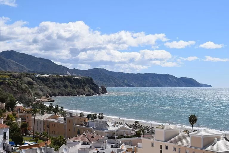
Playa de Burriana is Nerja’s largest town beach: about 800 m of sand on the east side of Nerja (Málaga), roughly 1 km from the Balcón de Europa. You reach it on foot from the centre, by car to the municipal car park behind the sand, or by town bus. In 2026 it flies a Blue Flag and holds the Q de Calidad Turística, and it has lifeguards, accessible bathing points, sunbed hire and a long row of restaurants on the promenade. It suits families and anyone who wants a full-service beach within walking distance of Nerja; skip it in August if you dislike crowds, or if you want a quiet cove.
Quick facts
- Names: Playa de Burriana, Playa Burriana or Burriana beach. Not to be confused with Burriana (Borriana), a town in Castellón province.
- Where: east side of Nerja town, municipality of Nerja, Axarquía, Málaga province. About 1.1 km east of the Balcón de Europa in a straight line.
- Coordinates: 36.7503, -3.8663.
- Size: 800 m long and about 40 m wide (spain.info beach sheet). Spain.info’s Nerja town page says “some 700 metres”, so treat the length as approximate.
- Surface: sand. Spain.info classes it as dark sand.
- Water: moderate waves (spain.info).
- Awards 2026: Blue Flag and Q de Calidad Turística (Nerja town hall).
- Character: urban beach with high occupancy (spain.info).
- Entry: free.
Access and parking
On foot from the centre: Burriana is the beach you can walk to from Nerja. Spain.info places it about a kilometre from the town, and it lies 1.1 km in a straight line from the Balcón de Europa. Spanish Wikipedia names two main ways in, from Calle Filipinas and from the Camino de Burriana; both come down from the residential streets above the beach.
By car: the Aparcamiento Municipal de Burriana is the town hall’s car park for the beach. In June 2026 the town hall awarded a contract to add a real-time guidance system showing free spaces, funded by EU NextGenerationEU money (nerja.es). On OpenStreetMap the multi-storey car park is mapped behind the west half of the beach as a paid car park, and a free surface car park is mapped near the western end. We could not confirm prices or capacity. A loading zone in the middle of the Paseo de Burriana is reserved for deliveries from 8:00 to 14:00 except on Sundays; outside those hours the spaces can be used by beach visitors (nerja.es, May 2026).
By bus: Spanish Wikipedia says line 1 of the Nerja town bus serves Burriana, and OpenStreetMap shows bus stops on the Paseo de Burriana near the west end. We could not confirm the 2026 timetable.
By boat: spain.info names Marina del Este, 16 km away, as the nearest marina.
What to expect
A long, open crescent of sand backed by a promenade, the Paseo Marítimo Antonio Mercero, with apartment blocks and gardens on the slope behind. Spain.info describes a promenade lined with souvenir shops, bars, restaurants and beach bars, and notes a beach library where you can borrow a book. At the eastern end the sand gives way to low cliffs and small beaches mapped on OpenStreetMap as Playa Piedra de Tarzán; to the west, past a rocky point, lies the smaller Playa Carabeillo, below the Mirador del Bendito viewpoint and the Parador hotel. Spain.info’s Nerja page notes that the Parador de Turismo stands on the cliff overlooking the beach.
Burriana still has a fishing side. In August 2026 the town council allocated the use of all sixteen fishermen’s huts on the beach, one of them kept for municipal services, and asked the regional government to authorise the boat slipway (nerja.es). The best-known restaurant at the east end is Ayo, mapped on OpenStreetMap as La Parrala “Ayo”; the town’s Media Legua Playa de Burriana race, held for the 32nd time in 2026, was a tribute to Ayo that year.
The beach is busy. Spain.info rates its occupancy as high, and in July and August expect rows of sunbeds and a full car park by late morning.
Practical details
- Services listed by spain.info: sunshade and sunbed hire, water-sports hire, toilets, showers, foot washes, a tourist information point, litter bins, cleaning, a sports area, a children’s play area and a diving area.
- Toilets: OpenStreetMap shows free public toilets on the promenade, some marked as wheelchair accessible.
- Water sports: Spanish Wikipedia mentions paddle surf, kayaking and snorkelling from the beach. Nerja town hall publishes a list of companies authorised to run activities on its beaches; check that list before you book.
Accessibility and safety
In July 2026 Nerja renewed the equipment at the accessible bathing points on Burriana so that people with reduced mobility can get into the sea (nerja.es). The 2026 lifeguard service across Nerja’s beaches had 50 staff, new watchtowers and two drones (nerja.es). Lifeguards work in the bathing season; outside it, treat the beach as unsupervised.
Storm damage: in February 2026 storms damaged the western part of the promenade near the fishermen’s hut and the lift up to the Parador, and the path from Burriana to Carabeillo and the Mirador del Bendito was closed (nerja.es). In April 2026 the town asked the Spanish ministry responsible for the coast to rebuild that stretch urgently (nerja.es). We could not confirm whether it has reopened; follow the signs on site.
Best time to visit
June and September give warm water, working beach services and fewer people than July and August. In high summer arrive early for parking. Spring and autumn are good for a walk along the promenade and a long lunch, with most restaurants open.
Nearby alternatives
- Balcón de Europa, 1.1 km away: the viewpoint in the centre of Nerja, with smaller beaches below it.
- Nerja, 1.0 km away: our guide to the town.
- Caves of Nerja, 2.3 km away: the show caves above Maro.
- Torre de Maro, 3.3 km away: a coastal watchtower above the Maro coves.
- Maro–Cerro Gordo Cliffs Natural Park, 5.7 km away: the protected cliffs and coves east of Maro.
- Playa del Cañuelo, 6.9 km away: a gravel beach below the cliffs, quieter and harder to reach.
Distances are in a straight line from the beach. For the whole stretch from Rincón de la Victoria to Nerja, see our Axarquía coast and Nerja guide.
FAQ
How do I get to Burriana beach from Nerja centre?
Walk east from the Balcón de Europa; the beach is about 1 km away. Spanish Wikipedia says town bus line 1 also stops there.
Is there parking at Burriana beach?
Yes. The municipal Aparcamiento de Burriana is behind the beach, and OpenStreetMap shows a free surface car park near the west end. In summer both fill up by late morning.
Does Burriana have a Blue Flag?
Yes. In 2026 Burriana is one of Nerja’s four Blue Flag beaches, with Torrecilla, Playazo-Chucho and Maro, and it also holds the Q de Calidad Turística.
Is Burriana beach sandy?
Yes, it is a sand beach about 800 m long and 40 m wide. Spain.info describes the sand as dark.
Is Burriana good for children?
It has lifeguards in season, a children’s play area, toilets and restaurants close to the sand. Waves are usually moderate.
Sources and freshness
Checked 7 November 2026 · 6 sources Show
Checked 7 November 2026. Official: spain.info, Playa de Burriana (Turespaña: size, sand, services, access, nearest marina, beach library) and spain.info, Nerja (Parador); Nerja town hall news on the 2026 Blue Flags, Q de Calidad and lifeguards, the car park, loading zone, fishermen’s huts, accessible bathing points and storm damage (linked above). Background: Spanish Wikipedia (access streets, town bus). Location, car parks, toilets, bus stops, restaurants and distances: OpenStreetMap contributors (ODbL). The Nerja tourist office site (turismo.nerja.es) could not be reached when we checked. Photo: Wikimedia Commons, licence as credited.
This place is part of our Costa del Sol travel guide: where it is, towns and beaches — see every town, beach and cove we have mapped on that coast.
How this page is made. CostaMap is written with an AI editorial system run by Ebizapple. This page is based on the sources listed above. Last updated 6 November 2026. Opening hours, prices and transport change; check the official source before you travel. How we work · Partner links and ads