
Playa de los Bateles (Conil de la Frontera)
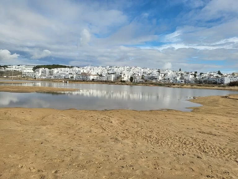
BeachPlaya de los Bateles is the town beach of Conil de la Frontera, on the Atlantic coast of Cádiz province: a wide strip of golden sand directly below the old town, the Torre de Guzmán and the palm-lined promenade. You can walk to it from anywhere in the centre, and there are car parks, a town bus stop and a full set of beach services behind the sand. It suits families, people without a car and anyone who wants cafés and toilets close by; skip it if you want an empty, natural beach, and head north to the coves of Roche or south to Castilnovo instead.
Quick facts
- Names: Playa de los Bateles, Playa Los Bateles or simply Los Bateles; locally the town beach of Conil.
- Where: in front of the town of Conil de la Frontera, La Janda, province of Cádiz; between the mouth of the Río Salado to the south and the low cliff of the Mirador del Jabiguero to the north (OpenStreetMap).
- Coordinates: 36.2735, -6.0925 (centre of the beach).
- Size: Andalucía.org gives 1,300 m long and 130 m wide; spain.info gives 850 m by 130 m. The sand mapped in OpenStreetMap measures about 1.3 km from end to end.
- Type: urban beach of golden sand with moderate waves, often windy (Andalucía.org, spain.info).
- Services: lifeguards, toilets, showers, sunshade and sun-lounger rental, a tourist office, a children’s play area and access for people with disabilities (Andalucía.org).
- Entry: free.
Access and parking
On foot: the beach starts at the bottom of the old town. From the Torre de Guzmán it is about 250–300 m to the sand. Spain.info notes that you reach the beach over wooden walkways from the promenade, which runs along the back of the sand.
By car: Conil lies just off the A-48 dual carriageway between Cádiz and Vejer; spain.info names the CA-4202 as the nearest road to the beach. In summer the old town streets are narrow and busy, so leave the car at the edge of the centre.
Parking: OpenStreetMap shows a large free car park about 100 m behind the southern part of the beach, near the mouth of the Río Salado, and several smaller paid car parks along the promenade, two of them for customers only. Street parking marked as allowed for motorhomes lies a little further south-east. Spaces fill early on summer weekends.
By bus: the Conil town bus, run by the municipal company ROSAM, stops at “Playa de Los Bateles” on the promenade (OpenStreetMap). We could not confirm the current timetable; regional coaches link Conil with Cádiz, Chiclana and Vejer.
What to expect
Los Bateles is the busiest beach in Conil and the one with the most services. Andalucía.org describes a beach “in front of Conil de la Frontera” with a wide range of services, recommended for windsurfing. Spain.info adds a broad promenade with palm trees, bars, hotels and restaurants, and says the beach draws surfers.
The sand. The beach is wide, flat and golden. At its southern end the small Río Salado reaches the sea; beyond the river the coast continues as the long, undeveloped beach of Castilnovo, which Andalucía.org lists at 2,900 m. At the northern end the town sits on a low cliff with the Mirador del Jabiguero viewpoint above the sand, and beyond it begins the beach of La Fontanilla.
The sea. Both official sources describe moderate waves; Andalucía.org also calls the water calm. This is the open Atlantic, though, and conditions change with the wind and the tide. When the westerly wind blows, the waves build up; when the easterly Levante blows hard, sand is lifted across the beach. Spain.info suggests the coves of Roche or Fuente del Gallo beach, sheltered by cliffs, on Levante days.
The town behind. Directly above the beach stand the Torre de Guzmán, a 14th-century military tower (spain.info), and the remains of the castle built around 1295 by Alonso Pérez de Guzmán (OpenStreetMap, citing the Andalusian heritage institute IAPH). Conil’s history is tied to the almadraba, the tuna-trap fishery that Phoenicians and Romans already used on this coast (Andalucía.org). The old tuna-processing site of La Chanca, a few streets back from the beach, now holds an interpretation centre on the sea, tuna and the almadrabas; OpenStreetMap marks it as free to enter.
Practical details
- Facilities: Andalucía.org lists parking, lifeguards, toilets, cleaning, a rescue team, a promenade, sunshade and lounger rental, a tourist office, showers, bins, warning signs, a children’s play area and a public phone.
- Toilets and water: OpenStreetMap shows wheelchair-accessible public toilets at the southern end and several drinking-water fountains along the promenade.
- Food: the promenade and the streets behind it are lined with bars and fish restaurants, which OpenStreetMap maps in dozens. Many beach businesses on this coast open only from May to October (spain.info).
- Bikes: there are bicycle racks next to the promenade (OpenStreetMap).
- Dogs: we could not confirm the current dog rules for Los Bateles; check the signs at the beach entrances.
- Tourist information: Conil tourist office, +34 956 440 501, turismo@conil.org (Andalucía.org).
Accessibility and safety
Andalucía.org rates the beach as accessible for people with disabilities and notes good access to the sand. Wooden walkways run from the promenade across the sand, and the free car park at the southern end and the paid car parks on the promenade are marked as wheelchair accessible in OpenStreetMap.
The beach is guarded in the bathing season only. Swim near the lifeguard posts and follow the flags: red means no swimming. Atlantic waves and currents can be strong on windy days, and the river mouth at the southern end has its own currents. In summer, bring shade: the Levante can blow sand hard enough to sting.
Best time to visit
July and August are the busiest months, when the town fills and parking is hardest; go early in the morning or after 6 pm. June and September have warm water, lifeguards on duty (check the dates each year) and fewer people. Out of season the beach is good for long walks to Castilnovo or La Fontanilla, but many beach bars are closed. Sunsets over the sea are the main event of a summer evening.
Nearby alternatives
- Playa de la Fontanilla – the next beach north, past the Jabiguero cliff, about 1.3 km away in a straight line.
- Playa El Palmar – a long, open surf beach in Vejer municipality, about 6.4 km to the south-east.
- Los Caños de Meca – beaches under the pine-topped cliffs of La Breña, about 11 km south-east.
- Cabo de Trafalgar – the lighthouse and dunes of the cape, about 11 km south-east.
- Vejer de la Frontera – the white hill town, about 12 km inland.
- Playa de la Barrosa – Chiclana’s long beach, about 13 km to the north-west.
For the whole town, see our Conil de la Frontera guide.
FAQ
Is there parking at Playa de los Bateles?
Yes. OpenStreetMap shows a large free car park about 100 m behind the southern end of the beach and several paid car parks along the promenade. In July and August they fill early.
How do I get to Los Bateles beach?
Walk down from the old town of Conil; the sand is about 250–300 m from the Torre de Guzmán. The Conil town bus stops at “Playa de Los Bateles” on the promenade.
Can you swim at Los Bateles?
Yes. Official sources describe moderate waves and lifeguard cover in the season. Stay near the lifeguard posts and follow the flags, as the Atlantic can be rough on windy days.
Is Los Bateles good for families?
It is Conil’s most family-friendly beach: lifeguards, toilets, showers, a play area and restaurants are all within a few steps, and the sand is wide and flat.
Which Conil beach is best when the Levante blows?
Spain.info recommends the coves of Roche or Fuente del Gallo beach, which are sheltered by cliffs, on days when the strong easterly Levante wind is blowing.
Sources and freshness
Checked 7 November 2026 · 7 sources Show
- Checked 7 November 2026. Andalucía.org: Playa Los Bateles (size, services, accessibility, tourist office contact)
- spain.info: Los Bateles (size, promenade, walkways, services, nearest road)
- Andalucía.org: Playa Castilnovo
- Andalucía.org: Conil de la Frontera (almadraba history)
- spain.info: Conil de la Frontera (Torre de Guzmán)
- spain.info: Cádiz coast (Levante shelter, season)
- OpenStreetMap: Playa de los Bateles and the surrounding map data (parking, toilets, bus stop, La Chanca, castle). Photo: Wikimedia Commons (Conil playa de los Bateles)
This place is part of our Costa de la Luz, Spain: beaches, towns, sherry and map — see every town, beach and cove we have mapped on that coast.
How this page is made. CostaMap is written with an AI editorial system run by Ebizapple. This page is based on the sources listed above. Last updated 6 November 2026. Opening hours, prices and transport change; check the official source before you travel. How we work · Partner links and ads