
Torre del Tajo cliff walk (Sendero del Acantilado, Barbate)
Hiking trailThe Torre del Tajo cliff walk, officially the Sendero del Acantilado (SL-A 111), is a 7.2 km path along the top of the Barbate cliffs, from Hierbabuena beach just west of Barbate port to Los Caños de Meca. Halfway along it passes the Torre del Tajo, an old coastal watchtower on the highest part of the cliff, with views over the sea to Barbate and the coast towards Zahara. It suits anyone who can walk a few hours on sandy forest tracks; skip it in the midday heat of summer or on days of strong Levante wind, and do not go near the edge with small children.
Quick facts
- Names: Sendero del Acantilado (Spanish for “cliff path”), signed SL-A 111; usually called the Torre del Tajo walk or the Barbate cliff walk. The cliff itself is the Acantilado de Barbate or El Tajo.
- Where: La Breña y Marismas del Barbate natural park, municipality of Barbate, province of Cádiz.
- Coordinates: 36.1880, -5.9446 (start above Hierbabuena beach); Torre del Tajo 36.1789, -5.9729.
- Distance: 7.2 km one way, from Playa de la Hierbabuena to Los Caños de Meca (Andalucía.org).
- Climb: about 100 m of ascent and 100 m of descent (OpenStreetMap route data).
- Waymarks: white and green stripes, the colours of local trails (SL) in Andalusia (OpenStreetMap).
- Surface: sand, gravel and dirt paths through pine forest (OpenStreetMap).
- Entry: free; no permit needed for the marked path.
Access and parking
Barbate end: the path starts in the pines above Playa de la Hierbabuena, about 1 km west of the marina of Barbate. OpenStreetMap shows a free car park at the start of the path (36.1904, -5.9437) and parking areas above the beach; the natural park information point is at the marina, about 900 m away.
Caños de Meca end: the path finishes at the eastern end of Los Caños de Meca. OpenStreetMap shows free car parks and toilets at the Majales del Sol picnic area, about 1.4 km north-east of the end of the path, and paid car parks near the beach.
Shorter way to the tower: a separate 2 km path, the Sendero de la Torre del Tajo, runs from a free car park in the pine forest (36.1868, -5.9552 on OpenStreetMap) through the trees to the tower. Use it if you only want the viewpoint.
Getting back: the route is one way. Either walk back the same way (14.4 km in all), leave a second car at the other end, or take a taxi. Coaches of Transportes Generales Comes link Barbate and Los Caños de Meca, but we could not confirm a timetable that suits walkers.
What to expect
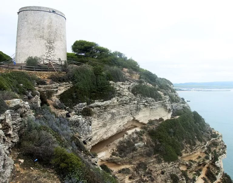
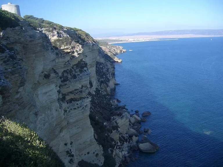
The cliff. The Barbate cliff is a sheer wall of pale calcarenite that Andalucía.org describes as “a tremendous cut of 90 metres” running along up to 6 km of coast; spain.info gives “almost one hundred metres”. The route description in OpenStreetMap mentions a cliff of more than 100 m shaped by sea erosion. The path mostly stays inside the forest and opens onto the edge at viewpoints.
The forest. Most of the walk is under the Pinar de la Breña, a forest of stone pine and Aleppo pine with thickets of juniper and a scrub that changes with exposure to the wind (Andalucía.org). The sandy ground makes the walk slower than its height gain suggests.
The Torre del Tajo. About 2.8 km from the start along the path, the tower stands on the cliff edge, with two viewpoints and a picnic table beside it (OpenStreetMap). It is one of the old watchtowers of this shore: Andalucía.org explains that a network of coastal towers protected the tuna fisheries of Zahara, El Palmar and Conil from Barbary corsairs until the mid-19th century. From here you look east to Barbate, its port and the coast towards Zahara, and down onto the rocks and clear water at the foot of the cliff.
Birds. Cattle egrets, jackdaws and peregrine falcons breed in holes in the cliff face, and ospreys and kestrels fly over it (Andalucía.org). Yellow-legged gulls are common (spain.info).
Los Caños de Meca. The last 2.7 km run west from the tower through the forest and drop to Los Caños de Meca, where fresh water runs down the cliff into the sea. Spain.info calls them small waterfalls.
Practical details
- Time: allow two to three hours one way at an easy pace with stops; this is our estimate for 7.2 km on sand, not an official figure.
- Water and food: we found no drinking water mapped on the path between the two ends. Carry at least 1.5 litres per person in warm weather; there are bars at both ends.
- Longer walks: the path is part of stage 3 of the GR 145 European Atlantic Arc trail, from Barbate to Cabo de Trafalgar (OpenStreetMap). Another marked trail, Caños–Torre de Meca, leads 4.3 km from the Majales del Sol picnic area to the 17th-century Torre de Meca and a viewpoint over the Trafalgar lighthouse (Andalucía.org).
- Information: the La Breña y Marismas del Barbate park information point, Avenida del Mar, Puerto de la Albufera (Barbate marina), +34 956 459 780 (Andalucía.org), explains the trails and runs guided activities.
Accessibility and safety
The path is not suitable for wheelchairs or pushchairs: it is narrow in places and runs over soft sand, including the short path to the tower.
Stay on the path and keep well back from the cliff edge. The cliff is high and vertical, the rock crumbles, and apart from the wooden railings at the tower viewpoint there is no barrier along most of it. Keep children and dogs close. In summer there is a high risk of forest fire: do not smoke or light any fire. Strong Levante wind makes the viewpoints dangerous.
Best time to visit
Autumn, winter and spring are the best seasons: cool enough to walk in the middle of the day. Andalucía.org lists the route for spring and summer, but in July and August start early in the morning and finish before noon. For sunset at the tower, bring a torch for the walk back.
Nearby alternatives
- Los Caños de Meca – the beaches at the western end of the walk, about 5 km from the tower.
- Cabo de Trafalgar – the lighthouse and dunes of the cape, about 5.6 km west of the tower.
- Barbate – the tuna port at the eastern end, about 2 km from the start.
- Vejer de la Frontera – the white hill town, about 7.5 km north of the start.
- Playa de Zahara de los Atunes – the long beach south-east of Barbate, about 10 km away.
- Playa El Palmar – the surf beach north-west of the cape, about 9 km from the tower.
For the whole park, see our guide to La Breña y Marismas del Barbate Natural Park.
FAQ
How long is the Torre del Tajo walk?
The full Sendero del Acantilado is 7.2 km one way, from Hierbabuena beach near Barbate to Los Caños de Meca. The tower is about 2.8 km from the Barbate end; a separate 2 km path reaches it from a car park in the forest.
Where do you park for the Torre del Tajo?
OpenStreetMap shows a free car park at the start of the path above Hierbabuena beach, another free car park in the pine forest at the start of the short tower path, and car parks at Majales del Sol near Los Caños de Meca.
Is the Barbate cliff walk difficult?
No technical skills are needed and the total climb is about 100 m, but the sand is tiring and there is no water on the way. It is a moderate walk for anyone used to a few hours on foot.
Can you walk from Barbate to Los Caños de Meca?
Yes. The signed SL-A 111 runs 7.2 km along the cliff top from Hierbabuena beach to Los Caños de Meca.
Sources and freshness
Checked 7 November 2026 · 8 sources Show
- Checked 7 November 2026. Andalucía.org: Sendero del Acantilado (distance, start and end, Torre del Tajo)
- Andalucía.org: Caños–Torre de Meca
- Andalucía.org: La Breña y Marismas de Barbate (cliff height and length, forest, birds)
- Andalucía.org: park information point
- Andalucía.org: Vejer de la Frontera (coastal towers)
- spain.info: La Breña y Marismas del Barbate Natural Park
- spain.info: Cádiz coast (Caños de Meca waterfalls)
- OpenStreetMap: Sendero del Acantilado route (waymarks, climb, description), Torre del Tajo and the surrounding map data (paths, car parks, toilets, GR 145). Photos: Wikimedia Commons (Breña.jpg, Acantilado con tajo)
This place is part of our Costa de la Luz, Spain: beaches, towns, sherry and map — see every town, beach and cove we have mapped on that coast.
How this page is made. CostaMap is written with an AI editorial system run by Ebizapple. This page is based on the sources listed above. Last updated 6 November 2026. Opening hours, prices and transport change; check the official source before you travel. How we work · Partner links and ads