
Cabo de Trafalgar (Los Caños de Meca, Barbate)
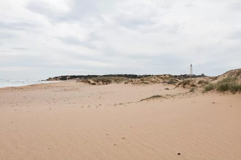
ViewpointCabo de Trafalgar (Cape Trafalgar) is the low headland with a white lighthouse between Los Caños de Meca and Zahora, in the municipality of Barbate on the Costa de la Luz. The Battle of Trafalgar was fought off this cape on 21 October 1805. You reach it on foot: the lighthouse road is closed to private cars, so park in Los Caños de Meca and walk about 1 km along the beach or the boardwalks over the dunes. It suits walkers, sunset-watchers and anyone with an interest in naval history; skip it if you want a museum or visitor centre, because there is none.
Quick facts
- Names: Cabo de Trafalgar or Cabo Trafalgar; in English Cape Trafalgar. The protected area is the Monumento Natural Tómbolo de Trafalgar. The name comes from Arabic, either Taraf al-Ghar (“cape of the cave”) or Taraf al-Gharb (“cape of the west”).
- Where: Los Caños de Meca, Barbate (Cádiz), between the beaches of Los Caños de Meca to the east and Zahora to the west.
- Coordinates: 36.1829, -6.0352 (the lighthouse).
- Protection: natural monument since 2001, 241,876 m² (about 24 ha), declared mainly for its geology; the cape and its surroundings are also a Site of Community Importance, “Punta de Trafalgar”, of 183.31 ha (Spanish Wikipedia).
- Lighthouse: built in 1860, 34 m tall and 51 m above sea level (Andalusia tourism board), first lit on 15 July 1862 (English Wikipedia). Still in service.
- Entry: free; open ground.
Access and parking
On foot: the asphalt road out to the lighthouse is marked on OpenStreetMap as private for vehicles, so plan to walk. Wooden boardwalks cross the dunes on the tombolo, and you can also walk along the sand from Los Caños de Meca beach. The lighthouse is about 1 km in a straight line from the Caños de Meca car parks.
Parking: OpenStreetMap shows several car parks on the Caños de Meca side, about 1–1.2 km north-east of the lighthouse, around the Camping Faro de Trafalgar; some are marked paid or for customers only. In July and August they fill early, especially before sunset.
By road: the lighthouse’s postal address is on the A-2233, the coast road through Zahora and Los Caños de Meca. Barbate and Vejer are each about 10 km away in a straight line.
What to expect
A sandy spit leading to a small rocky former island, crowned by the lighthouse, with open Atlantic on three sides. The Andalusia tourism board explains why it is protected: it is the only double tombolo in Andalusia. About 6,500 years ago, when the sea reached its present level, sand carried by the tides built two tongues of sand that joined the islet to the coast and enclosed a hollow that rain then flooded. Wind later piled up dunes on the beaches south of the islet.
- The lighthouse: designed by Eduardo Saavedra, who received the commission in 1857. Its tower was strengthened in 1929 with buttresses joined by pointed arches, after a heavier lamp was installed in 1926. A plan to turn it into a luxury hotel was rejected in 2018 (Spanish Wikipedia).
- History in the ground: around the lighthouse there are remains of a Roman fish-salting factory, a Roman temple and a watchtower. In 2018 remains of a Roman building were found in a part of the tombolo reachable only at low tide, and in 2021 Roman baths emerged from the dunes (Spanish and English Wikipedia).
- The battle: on 21 October 1805 the British fleet under Nelson defeated the combined French and Spanish fleet off the cape. The tourism board puts the dead at about 5,000. There is no monument or museum on the cape itself: what you get is the view of the sea where it happened.
- Nature: sea stock, sea daffodils and sea holly flower on the sand. The flooded hollow attracts Audouin’s gulls, sandpipers, Sandwich and Caspian terns, bar-tailed godwits and little egrets (tourism board).
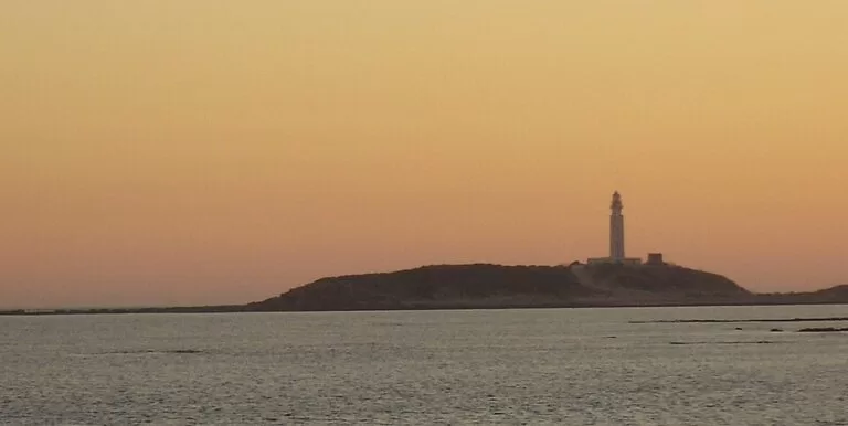
The International Hydrographic Organization uses a line from Cape Trafalgar to Cape Spartel in Morocco as the western limit of the Strait of Gibraltar (English Wikipedia). Spanish Wikipedia describes the cape as the north-western end of the Strait.
Practical details
The tourism board lists windsurfing, kitesurfing and rod fishing as the main activities around the cape, with some walking, birdwatching and environmental education. A beach bar, the Chiringuito Faro Beach, stands about 650 m from the lighthouse on the Caños side (OpenStreetMap). There are no other facilities on the headland. Stay on the boardwalks across the dunes: the vegetation that fixes the sand is part of what the monument protects.
Accessibility and safety
The approach is on sand and wooden boardwalks; we could not confirm a step-free route to the lighthouse, and OpenStreetMap marks the lighthouse itself as not wheelchair accessible. The rocks around the old islet are slippery, and the archaeological area near the low-tide line is cut off as the tide rises: check tide times before exploring. The cape is exposed to strong wind, and there is no shade.
Best time to visit
Sunset is the classic time, with the sun dropping into the Atlantic beside the lighthouse; in summer you will share it with many others. Spring and autumn are quieter, with migrating birds on the tombolo. Go at low tide if you want to walk around the rocks, and avoid strong easterly (levante) days if you want a calm beach.
Nearby alternatives
- Los Caños de Meca, 1.0 km away: the beach and village right next to the cape, where most visitors park.
- Barbate, 10.2 km away: tuna-fishing town on the coast to the south-east.
- Vejer de la Frontera, 10.2 km away: white hill town inland.
- Conil de la Frontera, 11.5 km away: beach town to the north-west.
- Playa de la Fontanilla, 12.4 km away: Conil’s town beach.
- Baelo Claudia, 25.6 km away: the Roman fish-sauce town on Bolonia beach.
Distances are in a straight line from the lighthouse.
FAQ
How do I get to Cabo de Trafalgar?
Drive to Los Caños de Meca on the A-2233 coast road, park on the Caños side and walk about 1 km to the lighthouse along the beach or the boardwalks. The lighthouse road is closed to private vehicles.
Is there parking at Cabo de Trafalgar?
Not at the lighthouse. The nearest car parks are in Los Caños de Meca, about 1–1.2 km away; some are paid or for customers only.
Can you go inside the Trafalgar lighthouse?
It is a working lighthouse, and we could not confirm any regular public visits inside. You can walk freely around the headland outside it.
Where was the Battle of Trafalgar fought?
In the Atlantic off this cape, on 21 October 1805, between the British fleet under Nelson and the combined French and Spanish fleet.
What is the best time to visit Cabo de Trafalgar?
Late afternoon for the sunset, outside July and August if you want it quiet, and at low tide if you want to explore the rocks.
Sources and freshness
Checked 6 November 2026 · 7 sources Show
Checked 6 November 2026. Official: Andalusia tourism board listings for the Tómbolo de Trafalgar (geology, wildlife, archaeology, battle, activities) and the Faro de Trafalgar (date, height). The Barbate town hall site could not be reached. Background: Spanish Wikipedia on Cabo Trafalgar, the Tómbolo de Trafalgar and the lighthouse; English Wikipedia (first lighting, Strait limit, 2021 finds). Location, road access, parking and distances: OpenStreetMap contributors (ODbL). Photos: Wikimedia Commons, licences as credited.
This place is part of our Costa de la Luz, Spain: beaches, towns, sherry and map — see every town, beach and cove we have mapped on that coast.
How this page is made. CostaMap is written with an AI editorial system run by Ebizapple. This page is based on the sources listed above. Last updated 6 November 2026. Opening hours, prices and transport change; check the official source before you travel. How we work · Partner links and ads