
La Breña y Marismas del Barbate Natural Park (Barbate)
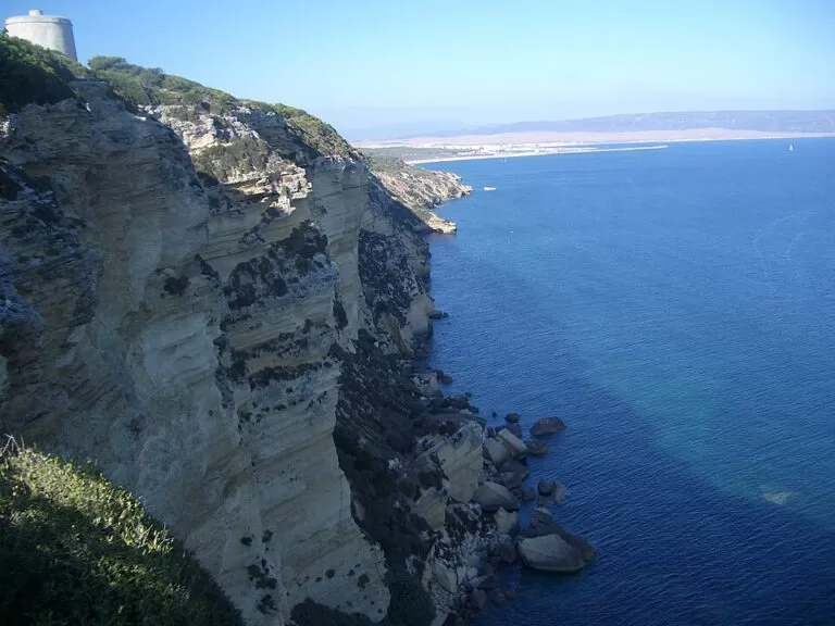
Natural parkLa Breña y Marismas del Barbate Natural Park is a protected stretch of the Cádiz coast between Barbate and Los Caños de Meca: a pine forest on a cliff up to about 100 m high, small beaches and coves below it, and the salt marshes of the Barbate river behind the town. The main ways in are the free walking paths from Barbate’s Hierbabuena beach and from Los Caños de Meca, and the park information point is at Barbate marina. It suits walkers, birdwatchers and people who want quiet beaches with trees behind them; skip it if you want lifeguarded resort beaches or are not prepared for heat and sand.
Quick facts
- Names: Parque Natural de La Breña y Marismas del Barbate (also written “de Barbate”); in English La Breña Natural Park or the Breña and Barbate Marshes Natural Park. Breña is the local name for the pine forest (spain.info).
- Where: municipalities of Barbate and Vejer de la Frontera, province of Cádiz, between the Bay of Cádiz and the Strait of Gibraltar (spain.info, Andalucía.org).
- Coordinates: 36.1954, -5.9546 (the pine forest above the cliff, as given by Andalucía.org).
- Size: 5,077 hectares (spain.info).
- Protected since: 27 July 1989 (Andalucía.org).
- Main landscapes: the marine and coastal strip, the cliff, pine forests, marshes and small dunes (spain.info).
- Entry: free; the marked paths and beaches are open to everyone.
Access and visitor information
Information point: the park information point is at Barbate marina (Avenida del Mar, Puerto de la Albufera), +34 956 459 780. Andalucía.org says it gives information on the park and its facilities, has a small exhibition and sells maps and books, and organises walks, horse rides, guided visits to the fish canneries, birdwatching routes and other activities. Spain.info adds that it also explains the Battle of Trafalgar, fought off this coast in 1805. We could not confirm its opening hours; check before you go.
Park office: Calle Coghen 3, Barbate, +34 856 580 010 (Andalucía.org).
By car: the A-2233 road runs through the pine forest between Barbate and Los Caños de Meca (OpenStreetMap). OpenStreetMap shows free car parks above Hierbabuena beach, in the forest at the start of the short Torre del Tajo path, and at the Majales del Sol picnic area near Los Caños de Meca, where there are also toilets.
By bus: Barbate and Los Caños de Meca are linked by the regional coach company Transportes Generales Comes; we could not confirm current timetables.
What to see
The cliff. Andalucía.org describes the cliff as “a tremendous cut of 90 metres” that runs along up to 6 km of coast; spain.info says it reaches almost 100 m. It is made of pale, layered rock, with the pine forest growing right up to its edge. Along the top stand old watchtowers, the Torre del Tajo on the highest part and the Torre de Meca further west.
The pine forest. Andalucía.org calls the Pinar de la Breña the park’s most outstanding feature: stone pine mixed with Aleppo pine, small woods of juniper and a scrub that changes with exposure to the wind. Brambles, fig trees and salt-tolerant plants cling to the cliff face.
The marshes. The second part of the park is the marsh of the lower Barbate river, north and east of Barbate town (spain.info). Andalucía.org describes a mosaic of reduced lagoons, channels and salt pans, with rice fields and pasture around them. Nearby lay the La Janda lagoon, one of the largest in Spain, drained in the mid-20th century; in very wet years it reappears for a few days (spain.info).
The coast and sea. Below the cliff are small coves, the sand spit (tómbolo) of Trafalgar and the corrales, stone-walled tidal fish traps used since Phoenician and Roman times. Where light reaches the clear water there are meadows of seagrass (Andalucía.org).
Wildlife
- On the cliff: cattle egrets, jackdaws and peregrine falcons nest in holes in the rock face; ospreys and kestrels hunt over it (Andalucía.org). Spain.info also names yellow-legged gulls.
- In the marshes: the wetlands are a nesting area and migration stop, with mallard, coot, grey and purple heron and common crane; Andalucía.org describes the crane here as the last breeding population in southern Europe. On the drier, steppe-like ground the tawny pipit occurs, a rare bird in this habitat.
- Mammals: otters, badgers and Egyptian mongooses live in the woods around the wetland (Andalucía.org).
- In the sea: small molluscs such as the dwarf winkle and limpets, and many fish species (Andalucía.org).
Walks and beaches
- Sendero del Acantilado (SL-A 111): 7.2 km along the cliff top from Hierbabuena beach to Los Caños de Meca, past the Torre del Tajo (Andalucía.org). See our Torre del Tajo cliff walk guide.
- Caños–Torre de Meca: 4.3 km from the Majales del Sol picnic area on sandy tracks through pines and eucalyptus to the 17th-century Torre de Meca and a viewpoint over the Trafalgar lighthouse and Los Caños de Meca; Andalucía.org calls it ideal for families.
- Playa de la Hierbabuena: 1,006 m of golden sand next to Barbate port, below the cliff and pines; dogs allowed from 1 October to 31 May (Andalucía.org). Spain.info notes windsurfing, diving and fishing.
- Los Caños de Meca: beaches and coves at the western end of the cliff, where fresh water runs down the rock; see our Los Caños de Meca guide.
- Playa de los Cañillos: 1,300 m of beach east of Barbate, close to the Barbate marshes, with views of the town and the cliff (Andalucía.org).
Accessibility and safety
The information point at the marina is listed as accessible for people with disabilities (Andalucía.org). The forest paths are sandy and not suitable for wheelchairs; the beaches at Hierbabuena and Los Caños de Meca are reached on foot over sand.
The cliff is vertical and its edge is unstable: stay on the marked paths. The coves below can only be reached at low tide in places and the rising tide can cut you off. Fire risk in the pine forest is high in summer: no smoking, no barbecues. Carry water, as there is none on the forest paths.
Best time to visit
Spring and autumn are the best seasons for walking and for birds on migration; winter is mild and quiet. In July and August the beaches are busy, parking is hard to find and the forest paths are hot after mid-morning. Strong Levante wind makes the cliff-top viewpoints uncomfortable.
Nearby alternatives
- Cabo de Trafalgar – the lighthouse and tómbolo just west of the park, about 7.4 km from the forest centre.
- Barbate – the tuna port on the park’s edge, about 3 km away.
- Vejer de la Frontera – the white hill town above the Barbate valley, about 6.5 km north.
- Playa El Palmar – the long surf beach north-west of the cape, about 10 km away.
- Playa de Zahara de los Atunes – the beach south-east of Barbate, about 11.5 km away.
- Baelo Claudia – the Roman town at Bolonia, about 20 km south-east.
FAQ
Where is La Breña Natural Park?
On the Atlantic coast of Cádiz province, in the municipalities of Barbate and Vejer de la Frontera: the cliffs and pine forest between Barbate and Los Caños de Meca, plus the marshes of the Barbate river behind Barbate town.
Do you have to pay to enter La Breña?
No. The park, its marked paths and its beaches are free. Guided activities organised by the information point may have a charge.
What is the best walk in La Breña?
The Sendero del Acantilado, 7.2 km along the cliff top from Hierbabuena beach to Los Caños de Meca past the Torre del Tajo. For a shorter, family walk, try the 4.3 km Caños–Torre de Meca path.
Can you take dogs to the beaches in La Breña?
Andalucía.org says dogs are allowed on Hierbabuena and Los Cañillos beaches from 1 October to 31 May. Keep them on a lead in the forest and away from nesting birds.
Sources and freshness
Checked 7 November 2026 · 10 sources Show
- Checked 7 November 2026. Andalucía.org: La Breña y Marismas de Barbate (landscape, flora, fauna, date of protection, office)
- Andalucía.org: park information point
- Andalucía.org: Barbate
- Andalucía.org: Sendero del Acantilado
- Andalucía.org: Caños–Torre de Meca
- Andalucía.org: Playa de la Hierbabuena
- Andalucía.org: Playa de los Cañillos
- spain.info: La Breña y Marismas del Barbate Natural Park (area, landscapes, La Janda, information point)
- spain.info: Hierbabuena
- OpenStreetMap map data (roads, car parks, toilets, towers). Photo: Wikimedia Commons (Acantilado con tajo)
This place is part of our Costa de la Luz, Spain: beaches, towns, sherry and map — see every town, beach and cove we have mapped on that coast.
How this page is made. CostaMap is written with an AI editorial system run by Ebizapple. This page is based on the sources listed above. Last updated 6 November 2026. Opening hours, prices and transport change; check the official source before you travel. How we work · Partner links and ads