
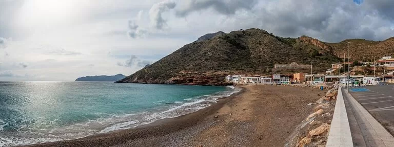
Playa de El Portús is a small beach of sand and pebbles in the fishing village of El Portús, 11 km from Cartagena by road, reached from km 2 of the RM-332 towards Isla Plana and La Azohía. The regional tourist board gives it 350 m of shore, about 16 m wide, with parking in the village and a summer beach bus from Cartagena. It suits divers, snorkellers and anyone who wants a village cove under the cliffs of the Sierra de la Muela; skip it if you want a long sandy resort beach or space to spread out in August.
Quick facts
- Names: Playa de El Portús or Playa del Portús (Spanish); El Portús is the village. Next to it, behind a headland, is Cala Morena.
- Where: El Portús, in the Perín district of Cartagena (Region of Murcia), on the coast west of Cartagena harbour.
- Coordinates: 37.5841, -1.0732.
- Size: 350 m long, average width 16 m (regional tourist board).
- Surface: medium sand and gravel; the tourist board calls the public beach a pebble beach.
- Crowds: the board rates occupancy as high.
- Protected setting: the beach lies in the Sierra de la Muela, Cabo Tiñoso y Roldán natural area, 7,776 ha of limestone mountain, cliffs and coves.
- Entry: free.
Access and parking
By car: from Cartagena take the RM-332 signed for Playa del Portús, Isla Plana and La Azohía; the turn to the beach is at km 2 (Region of Murcia tourism, El Portús beach).
Parking: the tourist board lists parking “in the village”. OpenStreetMap shows three car parks at the eastern end of the village, near the campsite, about 400–550 m on foot from the main beach. The board’s 2026 accessibility data lists two parking spaces reserved for people with reduced mobility, at the kerb by the beach.
By bus: ALSA urban line 4 runs from Cartagena to the village of Galifa, and urban line 12, the “Bus Playa”, runs from Cartagena to the beach in July and August only. The El Portús stop is about 300 m from the sand (OpenStreetMap). Check current timetables with the operator before you go.
What to expect
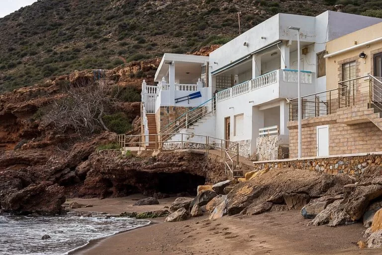
The beach is in two parts. The public beach in front of the village is the one the tourist board describes: pebbles and coarse sand, with the village houses just behind. Separated from it by a rocky promontory is Cala Morena, about 460 m east of the village beach, which you reach through the campsite (regional tourist board). The tourist board’s beach page still calls that campsite “naturist”; its current listing, under the name TAIGA Costa Cálida, describes a campsite with pitches, bungalows and apartments, a restaurant and direct access to Cala Morena, and does not mention naturism (campsite listing). OpenStreetMap tags both the campsite and Cala Morena as not naturist. We could not confirm the current rule, so check at the campsite reception if it matters to you.
The reason most people come is the water. The regional tourist board names Playa del Portús and Cabo Tiñoso as essential stops for divers, for the beauty and variety of the seabed (Region of Murcia tourism, Cartagena). The coast west of here, round Cabo Tiñoso, is a marine reserve with its own diving sites. Behind the beach the mountains rise steeply; the tourist board lists Bonelli’s and golden eagles, eagle owls, peregrine falcons, choughs and spur-thighed tortoises among the fauna of the natural area, and dwarf fan palm and juniper among the plants (natural area page).
Practical details
- Facilities: the tourist board’s 2026 data lists an adapted toilet, wooden walkways 2 m wide on the sand, an adapted shaded area of 3 × 3.4 m and an information panel at the entrance. OpenStreetMap shows a drinking-water tap and a beach bar at the village beach.
- Food: OpenStreetMap shows a beach bar and a restaurant in the village, and the campsite has its own restaurant.
- Dogs: we found no official dog rule for this beach; follow the signs at the entrance.
- Diving and kayaking: the regional tourist board lists active-tourism companies for this coast, among them PortusKayak and Rivemar at La Azohía. Do not dive alone.
Accessibility and safety
The tourist board rates the beach “practicable, equipped” for people with reduced mobility: no ramp is needed, a 2 m walkway runs over the sand, and one amphibious chair is available depending on sea conditions (2026 data). The pebbles are hard underfoot, so bring water shoes. The official page does not say whether lifeguards are on duty, so check the flag before you swim.
Best time to visit
June and September give warm water and fewer people than July and August, when the Bus Playa runs and the tourist board’s “high” occupancy rating applies. For diving and snorkelling, pick a calm day; the tourist board notes that the coast of Cartagena is protected from the east wind.
Nearby alternatives
- Cala Cortina, 8.7 km away: Cartagena’s town beach, reached through a tunnel, with full services.
- Roman Theatre of Cartagena, 8 km away: the museum and theatre in the old town, an easy pairing with a beach afternoon.
- Castillo de San Julián, 9.5 km away: the 19th-century fort above the harbour entrance, seen from the road and the sea.
- La Azohía, 9.2 km away: the fishing village at the foot of Cabo Tiñoso, with longer beaches and a 16th-century watchtower.
- Puerto de Mazarrón, 16.5 km away: the harbour town on the bay west of Cabo Tiñoso.
Distances are in a straight line from the beach.
FAQ
How do I get to El Portús beach?
By car, take the RM-332 from Cartagena towards Isla Plana and La Azohía and turn off at km 2 for the beach. By bus, line 12 (Bus Playa) runs from Cartagena to the beach in July and August; line 4 goes as far as Galifa all year.
Is there parking at El Portús?
Yes, in the village. OpenStreetMap shows three car parks near the campsite, 400–550 m from the beach, and the tourist board lists two reserved spaces for people with reduced mobility.
Is El Portús a nudist beach?
The public village beach is not. Cala Morena, next door and reached through the campsite, is described as naturist on the tourist board’s beach page, but the campsite’s current listing does not mention naturism. Both pages still said this when we re-checked them on 9 November 2026, so the rule is unconfirmed: ask at the campsite reception. Check on site.
Is El Portús good for snorkelling and diving?
Yes. The regional tourist board names El Portús and Cabo Tiñoso as essential stops for divers because of the variety of the seabed.
Is the beach sandy?
Not really. The tourist board describes medium sand and gravel, and a pebble beach in front of the village. Water shoes help.
Sources and freshness
Checked 7 November 2026 · 7 sources Show
Checked 7 November 2026. Official: Region of Murcia tourist board on El Portús beach (size, surface, buses, directions, 2026 accessibility data; Spanish version), the TAIGA Costa Cálida campsite, Sierra de la Muela, Cabo Tiñoso y Roldán, Cartagena and diving at La Azohía and Cabo Tiñoso. Cartagena’s own tourism site could not be reached for this update. Location, car parks, bus stop, beach bar and distances: OpenStreetMap contributors (ODbL). Photos: Wikimedia Commons, licences as credited.
How this page is made. CostaMap is written with an AI editorial system run by Ebizapple. This page is based on the sources listed above. Last updated 9 November 2026. Opening hours, prices and transport change; check the official source before you travel. How we work · Partner links and ads