
Cabo de Palos Lighthouse (Cartagena)
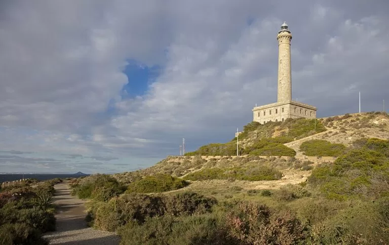
Historic siteThe Cabo de Palos Lighthouse (Faro de Cabo de Palos) stands on the tip of the cape at the southern end of La Manga del Mar Menor, in the municipality of Cartagena (Murcia). It was first lit on 31 January 1865, and its stone tower, 54 m tall on a square base, is the landmark of the whole Mar Menor coast. You can walk or drive up to the esplanade at its foot for free; the inside opens only on guided visits run by private companies. It suits walkers, photographers and anyone visiting Cabo de Palos village, 1.3 km away; skip it if you want a beach or shade.
Quick facts
- Names: Faro de Cabo de Palos in Spanish; in English usually Cabo de Palos Lighthouse or Cape Palos Lighthouse.
- Where: Subida al Faro, Cabo de Palos, Cartagena (Murcia), on a small peninsula that the regional tourist board describes as about 600 m wide (Murcia Turismo).
- Coordinates: 37.6347, -0.6903.
- Built: work started in 1863 to a design by Leonardo de Tejada; first lit on 31 January 1865. It stands on the site of an old watchtower (Murcia Turismo); the tourist board’s Cabo de Palos page dates that tower to the 16th century and says it was built against pirate raids (Murcia Turismo, Cabo de Palos).
- Size: a square base 20 m a side and 14 m high, and a tower 54 m high shaped as a Tuscan column, topped by a cylindrical turret with the lantern (Murcia Turismo).
- Light: a range of about 24 nautical miles (tourist board); two white flashes every 10 seconds, 81 m above the sea (OpenStreetMap).
- Protection: listed as a Bien de Interés Cultural (monument) in 2002, according to OpenStreetMap’s heritage data.
- Entry: free to the esplanade at the base; inside only on paid guided visits.
Access and parking
By car: from the Alicante–Cartagena motorway take exit 800 onto the MU-312 towards La Manga and Cabo de Palos (Murcia Turismo), then the Subida al Faro road up from the village.
Parking: OpenStreetMap shows a free surface car park about 150 m west of the lighthouse, below the hill. We did not check its size.
By bus: the tourist board lists Alsa buses on the Cartagena–La Manga line and a Murcia–La Manga line with stops in Cabo de Palos (Murcia Turismo, Playa de Levante). OpenStreetMap marks a bus stop on the lighthouse road, about 160 m from the base. We did not check 2026 timetables.
On foot: the Sendero Azul La Manga–Cabo de Palos, a signed easy walk of 7.5 km there and back, starts at the Entremares shopping centre in La Manga, follows the promenade into Cabo de Palos, climbs to the lighthouse and comes down the steps to the coves and the harbour (Murcia Turismo, Sendero Azul).
What to expect
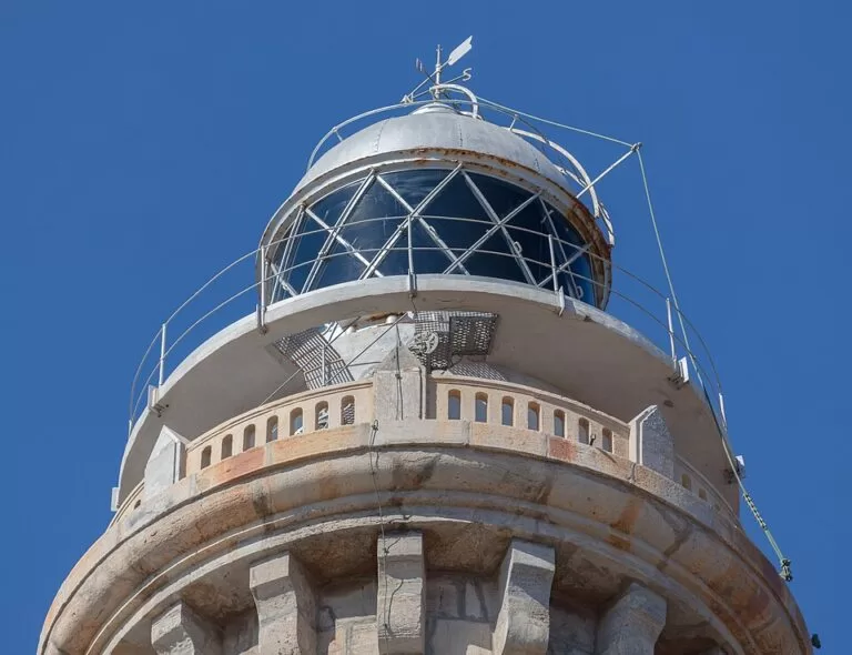
The lighthouse is a sober building of stone blocks brought from a quarry at El Sabinar, which also housed a school for lighthouse keepers in its square base. The column rises from an octagonal pedestal, and brackets under the capital hold a round cornice with an openwork balustrade (Murcia Turismo).
Most visitors come for the view. From the esplanade you look over the open Mediterranean, the marine reserve and, about 4.3 km out, the Islas Hormigas with their own small lighthouse. The sea floor around the cape is part of the Cabo de Palos–Islas Hormigas marine reserve, which the tourist board ranks among the most important in Europe (Murcia Turismo).
Below the lighthouse are the coves of the cape. The tourist board puts little Cala Túnez, also called Cala Cuna, at the foot of the lighthouse on the La Manga side, and Cala Fría on the other side. From Cala Fría a path runs past the coves of Las Escaleritas, El Muerto, Botella and Las Melvas to the harbour of Cabo de Palos (Murcia Turismo, Playa de Levante). Some coves are reached by small steps from this path, and all are good for snorkelling, the tourist board says (Murcia Turismo, Calas de Cabo de Palos). OpenStreetMap records Cala Túnez as pebbles and Cala Fría as gravel, so bring water shoes.
Visiting inside
The tourist board’s page says access is free as far as the esplanade at the base, and that visits inside are run by two private companies, which it links: visitaelfaro.com and a guided tour sold by thebestdaytours.com (Murcia Turismo). We could not open either site, so we cannot give prices, days, group sizes or whether you climb the tower. Book before you go.
Practical details
- Cost: free outside; guided visits are paid (prices not confirmed).
- Facilities: none confirmed at the lighthouse; cafés and toilets are in the village.
- Time needed: 20–30 minutes; half a day with the coves path or the Sendero Azul.
- Nearby museum: the Centro de Documentación y Exposición de Cabo de Palos, by the church at Paseo del Puerto 1, shows the sea floor of the region, the great shipwrecks off the cape such as the Sirio, the formation of the Mar Menor and seahorses in an aquarium. By appointment only, groups of 10 or more, €5 per person (Murcia Turismo, checked November 2026).
Accessibility and safety
OpenStreetMap tags the lighthouse as not wheelchair accessible. The road up is steep and the esplanade is open to the wind, with no shade. The path round the coves has uneven rock and steps, and there are cliff edges with no railing in places. For a step-free swim nearby, the tourist board rates Playa de Levante, just west of the lighthouse, as an accessible beach with assisted bathing in summer (Murcia Turismo).
Best time to visit
Late afternoon gives the best light on the tower; morning is cooler in summer. In July and August come early or walk up from the village, as parking is limited.
Nearby alternatives
- Cabo de Palos, 1.3 km away: the fishing village and harbour below the lighthouse.
- Islas Hormigas, 4.3 km away: the islets of the marine reserve, reached by boat from the harbour.
- Cala Reona, 2.8 km away: a small sandy cove at the start of the Calblanque coast.
- La Manga del Mar Menor, 3 km away: the 21 km sand strip between two seas.
- Calblanque, 4.9 km away: the regional park with undeveloped beaches south-west of the cape.
- Isla Grosa, 10.4 km away: the volcanic island off the north of La Manga.
Distances are in a straight line from the lighthouse.
FAQ
Can you go inside the Cabo de Palos Lighthouse?
Only on a guided visit with one of the private companies the regional tourist board links. Without one, you can walk freely to the esplanade at the foot of the tower.
Is there parking at the Cabo de Palos Lighthouse?
Yes. OpenStreetMap shows a free car park about 150 m from the lighthouse. It is small for summer, so arrive early or walk up from the village.
How tall is the Cabo de Palos Lighthouse?
The tower is 54 m high on a base 14 m high, according to the Murcia tourist board. The light shines about 81 m above the sea (OpenStreetMap sea-mark data).
When was the Cabo de Palos Lighthouse built?
Construction began in 1863 and the light was first lit on 31 January 1865, on the site of an older watchtower.
Can you walk from La Manga to the lighthouse?
Yes, on the signed Sendero Azul from the Entremares shopping centre: 7.5 km there and back, rated easy.
Sources and freshness
Checked 7 November 2026 · 9 sources Show
Checked 7 November 2026. Official: Murcia regional tourism (Instituto de Turismo de la Región de Murcia) pages on the Faro de Cabo de Palos (history, size, light, visits), Cabo de Palos, La Manga, Playa de Levante, the Calas de Cabo de Palos, the Sendero Azul and the Centro de Documentación; spain.info on Cabo de Palos. The visit operators’ sites (visitaelfaro.com, thebestdaytours.com) could not be reached. Location, light data, heritage listing, car park, bus stop and distances: OpenStreetMap contributors (ODbL). Photos: Wikimedia Commons, licences as credited.
This place is part of our Costa Cálida — the honest guide to Spain's warm coast — see every town, beach and cove we have mapped on that coast.
How this page is made. CostaMap is written with an AI editorial system run by Ebizapple. This page is based on the sources listed above. Last updated 6 November 2026. Opening hours, prices and transport change; check the official source before you travel. How we work · Partner links and ads