
Isla Grosa (La Manga, San Javier)
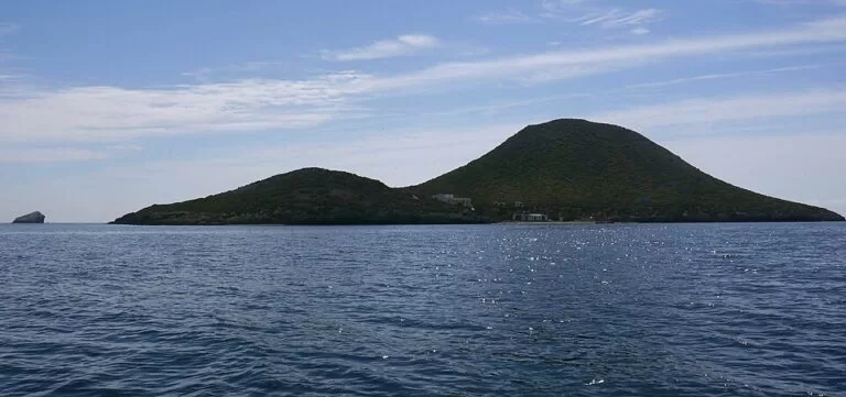
IslandIsla Grosa is a 17.5-hectare volcanic island in the Mediterranean off the northern end of La Manga del Mar Menor, in the municipality of San Javier (Murcia). You can only get there by boat, and most visitors see it on a dive trip from La Manga: the regional tourist board lists La Manga–Isla Grosa as one of the main dive areas of the Costa Cálida. The island is a protected seabird colony and a former navy training ground, and we could not confirm any public landing. It suits divers, snorkellers on organised trips and birdwatchers with binoculars; skip it if you want a beach to walk on.
Quick facts
- Names: Isla Grosa in Spanish. The name comes from the Catalan grossa, “big”. Not to be confused with the Illa Grossa of the Columbretes, off Castellón.
- Where: in the open Mediterranean off the northern end of La Manga del Mar Menor, municipality of San Javier (Region of Murcia). The islet of El Farallón lies about 670 m to the east.
- Coordinates: 37.7269, -0.7072 (the summit).
- Size: about 17.5 hectares; the top is a little over 90 m above the sea (OpenStreetMap has a survey point at 96.65 m).
- Origin: an eroded volcanic cone of andesite, from the same volcanic activity as the islands of the Mar Menor.
- Protection: part of the protected area Islas e Islotes del Litoral Mediterráneo, also a Site of Community Importance (LIC) and a Special Protection Area for birds (ZEPA).
- Distances: about 1.5 km from the nearest point of the La Manga shore on OpenStreetMap (Wikipedia gives 2.5 km from the north of La Manga) and about 3.7 km from the Tomás Maestre marina, in a straight line.
- Landing: we could not confirm from an official source whether, or when, the public may land.
Access and getting there
By boat only: there is no bridge or ferry. OpenStreetMap shows a small pier on the west side of the island, facing La Manga, and a handful of buildings. Wikipedia says the island was a military zone until 2000, used by the Spanish Navy’s diving centre to train combat divers and bomb-disposal teams, and that the only buildings date from that period. In 2000 it was handed to the regional government of Murcia for environmental use.
Can you land? We could not reach the regional nature site or San Javier town hall to check the rules. The island is a protected bird colony, so do not plan on landing; ask your operator first.
Diving trips: this is how most visitors get close. The regional tourist board lists “La Manga – Isla Grosa” as one of the main dive areas of the Costa Cálida, and says the region has 21 official dive centres, from try-dives to advanced courses.
What to expect under water
The regional tourist board describes the area around Isla Grosa as a protected zone surrounded by Posidonia seagrass meadows, with reefs that “create real aquariums” and remains of Phoenician and Roman ships as well as 19th-century cargo ships. Its dive sites, as listed on the official diving page:
- Isla Grosa: four different dives between 6 and 18 m, with many holes and overhangs that shelter groupers and corvinas.
- El Farallón: a couple of dives between 6 and 18 m around the islet; the board says almost 80% of the species of this coast live here.
- La Laja: a shoal rising from 18 m to 2 m, about 1.3 km north-east of the island, with moray eels and octopus.
- Anfiteatro: a rock formation at 13–18 m, known for nudibranchs.
- Cueva de la Grosa: a cave 120 m long, no deeper than 6 m, with shrimps and scorpionfish.
- Wrecks for experienced divers: the steamer SS Thordissa (“Carbonero”), 120 m long, sunk by a German U-boat in the First World War and resting at 45 m; the Italian steamer SS Doris (“El Cobre”) at 47 m; the Francolí (“El Azufre”) at 47 m; and the minesweepers Ulla and Turia, sunk by the Spanish Navy in 1999 off La Manga.
The shoal east of El Farallón, the Bajo de la Campana, was a hazard to shipping for centuries. A Phoenician wreck found there carried tin and lead ingots and African elephant tusks with Phoenician inscriptions; Wikipedia says its cargo is now in the National Museum of Underwater Archaeology (ARQVA) in Cartagena.
Above water: birds and geology
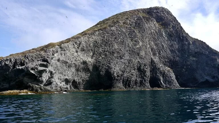
Isla Grosa is best known to naturalists for its birds. Wikipedia lists a large colony of yellow-legged gulls plus storm petrels, shags, peregrine falcons and Audouin’s gulls, and says the island holds one of the largest Audouin’s gull colonies in the world; a European LIFE project (2004–2007) worked to protect it. On the south cliffs you can see columnar jointing, the rock columns formed as lava cooled. Under the sea lies what Wikipedia calls the largest Posidonia meadow on the Murcia coast.
Accessibility and safety
There are no services on the island and no public access we could confirm. The wreck dives at 45–47 m are for qualified deep divers only; go with an official dive centre. The island is in the open sea, not the calm Mar Menor, so conditions can change quickly: check the forecast and keep away from the cliffs and the shallow La Laja shoal, which the tourist board calls a real trap for navigation.
Best time to visit
We could not find an official diving season for Isla Grosa; ask the dive centres in La Manga. Bird colonies are sensitive in the breeding season, so keep your distance from the cliffs in spring and early summer.
Nearby alternatives
- La Manga del Mar Menor, 9.2 km away: the long sand strip between the Mar Menor and the Mediterranean, where the dive boats leave.
- Islas Hormigas (Cabo de Palos), 9.4 km away: the islets of the Cabo de Palos marine reserve, another official dive area.
- Isla Perdiguera, 8.6 km away: the volcanic island in the middle of the calm Mar Menor lagoon.
- Cabo de Palos, 11 km away: the village and cape at the south end of La Manga.
- National Museum of Underwater Archaeology (ARQVA), 28 km away: in Cartagena, where finds from the waters around Isla Grosa are shown.
Distances are in a straight line from the island’s summit.
FAQ
Can you visit Isla Grosa?
You can reach the waters around it by boat, and dive centres in La Manga run trips there. We could not confirm from an official source whether the public may land, so ask your operator first.
How do I get to Isla Grosa?
Only by boat from La Manga. The island lies about 1.5–2.5 km off the northern end of La Manga and about 3.7 km from the Tomás Maestre marina.
Is Isla Grosa good for diving?
Yes, it is one of the official dive areas of the Region of Murcia. Sites include four dives around the island at 6–18 m, El Farallón, a 120 m cave no deeper than 6 m, and deep wrecks at 45–47 m.
Why is Isla Grosa protected?
It is part of the protected area Islas e Islotes del Litoral Mediterráneo, a Site of Community Importance and a Special Protection Area for birds, with colonies of Audouin’s and yellow-legged gulls.
Was Isla Grosa a military island?
Yes. It was a military zone until 2000, used by the Spanish Navy for diving and bomb-disposal training, and was then handed to the regional government for environmental use.
Sources and freshness
Checked 6 November 2026 · 6 sources Show
Checked 6 November 2026. Official: Region of Murcia tourist board, La Manga–Isla Grosa diving (dive sites, depths, wrecks, protection), diving in the Region of Murcia (21 dive centres) and Islas e Islotes del Litoral Mediterráneo (protected area, municipalities). The regional nature site and San Javier town hall could not be reached, so landing rules are not confirmed. Background (size, geology, birds, military history, Phoenician wreck): Spanish Wikipedia and English Wikipedia. Location, pier, summit height and distances: OpenStreetMap contributors (ODbL). Photos: Wikimedia Commons, licences as credited.
This place is part of our Costa Cálida — the honest guide to Spain's warm coast — see every town, beach and cove we have mapped on that coast.
How this page is made. CostaMap is written with an AI editorial system run by Ebizapple. This page is based on the sources listed above. Last updated 6 November 2026. Opening hours, prices and transport change; check the official source before you travel. How we work · Partner links and ads