
Islas Hormigas (Cabo de Palos, Cartagena)
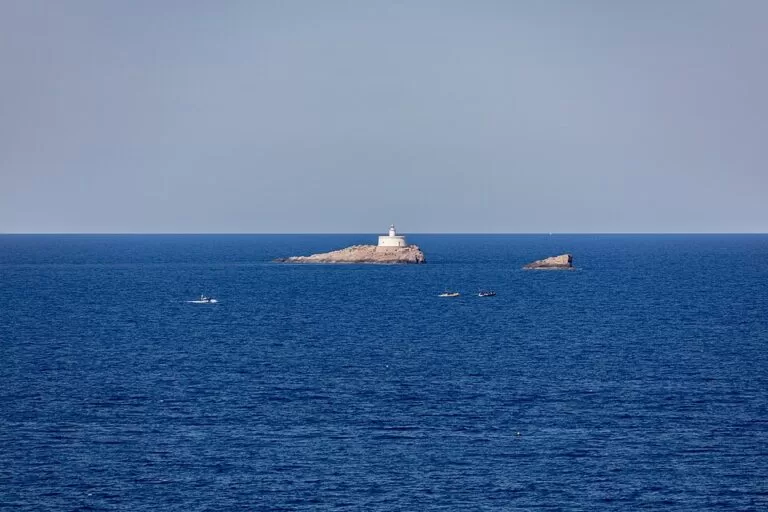
IslandThe Islas Hormigas are a small group of rocky islets about 4.3 km off the Cabo de Palos lighthouse, in the municipality of Cartagena (Murcia), on the Costa Cálida. You reach them only by boat, and most visitors go with one of the dive centres around the Cabo de Palos harbour, because the sea floor between the cape and the islands is a marine reserve and one of Spain’s best-known dive areas. The largest islet, Isla Hormiga, carries a white lighthouse. They suit certified divers, snorkellers on boat trips and anyone who likes looking at a lighthouse out at sea; skip them if you want to land, walk or sunbathe.
Quick facts
- Names: Islas Hormigas in Spanish (“Ant Islands”); spain.info calls them the Hormiga Islands. The islets on OpenStreetMap are Isla Hormiga, the Islote El Hormigón and the Islote La Losa.
- Where: off Cabo de Palos, Cartagena (Murcia), at the southern end of La Manga del Mar Menor. About 4.3 km from the Cabo de Palos lighthouse and 5.2 km from the harbour, in a straight line on OpenStreetMap. spain.info gives “2.5 miles away from the coast”.
- Coordinates: 37.6559, -0.6489 (Isla Hormiga).
- Size: small. Isla Hormiga covers roughly 9,000 m² on OpenStreetMap; El Hormigón, about 0.6 km to the south-west, is much smaller.
- Protection: the Cabo de Palos–Islas Hormigas marine reserve, protected since 1995 and covering about 19 km² between the lighthouse and the islands (Wikipedia).
- Lighthouse: on Isla Hormiga; a white light with three flashes every 14 seconds (OpenStreetMap).
- Population: none.
Access and the harbour
By boat only: there is no bridge or causeway. Trips start from the small harbour of Cabo de Palos, which faces the Playa de Levante and has five floating pontoons for leisure boats (Wikipedia). OpenStreetMap shows several dive shops around the harbour.
By car to Cabo de Palos: the main road in is exit 18 of the RM-12, the La Manga road; a second turn-off is next to the Las Dunas shopping centre. We did not check parking near the harbour or its prices; summer is busy.
By bus: Cabo de Palos is served by the Murcia region’s Movibus interurban network. We did not check 2026 timetables.
See our Cabo de Palos guide for the village itself.
What to expect
From the shore you see a low rock with a lighthouse and a smaller rock beside it. The interest lies under water. The Cabo de Palos promontory continues as an underwater ridge and breaks the surface again at the Islas Hormigas; its shallows are a danger to shipping (Wikipedia). The reserve is known for its Posidonia seagrass meadows and coral colonies, and spain.info describes the seabed as “one of the best scuba diving sites in Spain”, with reefs, coral and the remains of shipwrecks (spain.info).
The wrecks are part of the draw. The Italian liner Sirio sank off the cape on 4 August 1906 with heavy loss of life, and in October 1917 the German submarine U-35 sank four steamers near Isla Hormiga and Cabo de Palos (Wikipedia). The Sirio lies deep and is for experienced divers only.
The lighthouse has its own story. The first light on Isla Hormiga was built before the one on the cape, on a square plan. In a storm in November 1869 the sea swept away the keeper’s wife and three children; the keeper and his last child were rescued. A round tower replaced it, and in 1920 it became an automatic light, which Wikipedia calls the first in Spain.

Rules and practical details
- Integral zones: the reserve has zones of full protection where any activity is banned, and other zones where some activities are allowed with restrictions (Wikipedia). spain.info describes the seabed as an “Integral Marine Reserve”.
- Diving: go with a dive centre that works in the reserve and ask it about permits and the zones it may use. The reserve’s official pages (Spanish fisheries ministry and Murcia regional government) could not be reached from our checker, so we cannot quote the current permit rules or fees.
- Own boat: activities inside the reserve may be restricted; check the official rules on fishing and anchoring before you take your own boat out.
- Landing: we found no official information on landing on the islets, which have no services.
- Services: restaurants, bars, a pharmacy and shops are around the Cabo de Palos harbour (OpenStreetMap).
Accessibility and safety
The islands are in open sea, more than 4 km out, and the shoals around them have sunk ships; storms from the east hit this coast hard, as the 1869 lighthouse disaster shows. Do not attempt to paddle or swim out. Some wreck dives are deep and only for experienced divers. Boats and dive boats are generally not step-free; ask the operator before booking if you have reduced mobility.
Best time to visit
Choose a calm day: dive and boat trips depend on the sea, and the islands are exposed to strong easterly winds (levante). For a view from land, the hill of the Cabo de Palos lighthouse looks out towards the islands. We found no official season dates for boat trips.
Nearby alternatives
- Cabo de Palos, 5.5 km away: the fishing village and harbour where trips to the islands start.
- La Manga del Mar Menor, 6.5 km away: the long sand strip between the Mediterranean and the Mar Menor.
- Calblanque, 7 km away: the regional park with undeveloped beaches south-west of the cape.
- Isla Perdiguera (Mar Menor), 14.1 km away: the largest island in the Mar Menor lagoon.
- National Museum of Subaquatic Archaeology, 29.9 km away in Cartagena: underwater heritage from this coast.
Distances are in a straight line from Isla Hormiga.
FAQ
Where are the Islas Hormigas?
Off Cabo de Palos in Cartagena, Murcia, about 4.3 km from the Cabo de Palos lighthouse. Coordinates: 37.6559, -0.6489.
How do I get to the Islas Hormigas?
By boat from the harbour of Cabo de Palos, usually on a dive or boat trip. There is no public ferry that we could confirm.
Can you dive at the Islas Hormigas?
Yes, outside the zones of full protection. Go with a dive centre that works in the marine reserve and check the current permit rules with it.
Can you land on Isla Hormiga?
We found no official information that allows landing. The islet is bare rock with an automatic lighthouse and no services.
Can you see the Islas Hormigas from land?
Yes. On a clear day they are visible from the Cabo de Palos lighthouse area, about 4.3 km away.
Sources and freshness
Checked 6 November 2026 · 4 sources Show
Checked 6 November 2026. Official: spain.info, Cabo de Palos (distance, reserve, diving). The reserve’s official pages at the Spanish fisheries ministry, the Murcia regional government and Murcia’s tourism site could not be reached from our checker. Background: Wikipedia on the Cabo de Palos–Islas Hormigas marine reserve (size, year, zones, lighthouse history, Sirio) and on Cabo de Palos (harbour, roads, bus, 1917 wrecks). Location, islet names, sizes, light, dive shops and distances: OpenStreetMap contributors (ODbL). Photos: Wikimedia Commons, licences as credited.
This place is part of our Costa Cálida — the honest guide to Spain's warm coast — see every town, beach and cove we have mapped on that coast.
How this page is made. CostaMap is written with an AI editorial system run by Ebizapple. This page is based on the sources listed above. Last updated 6 November 2026. Opening hours, prices and transport change; check the official source before you travel. How we work · Partner links and ads