
Malpica (Malpica de Bergantiños) is a fishing town at the northern end of the Costa da Morte in Galicia, about 34 km west of A Coruña in a straight line, built on a small peninsula with the harbour on one side and the 800 m beach of Area Maior on the other. From the town you look out to the Sisargas Islands, and short drives lead to the chapel on Cabo San Adrián, the Punta Nariga lighthouse and the pottery village of Buño. It suits people who want a working port with a town beach, surfers, and anyone starting a Costa da Morte trip from A Coruña; skip it if you want calm water every day or a quiet resort with no fishing harbour.
Quick facts
- Names: Malpica de Bergantiños is the name of the municipality; the town itself is simply Malpica. Galician Wikipedia says the “de Bergantiños” was added in 1916 to tell it apart from Malpica in Toledo and Malpica de Arba in Zaragoza.
- Where: comarca of Bergantiños, province of A Coruña. The coast of the municipality runs from Monte Nariga in the west to Punta de Razo, the western end of Baldaio beach (Galician Wikipedia).
- Coordinates: 43.3226, -8.8107 (town centre, OpenStreetMap).
- Population: 5,232 in the whole municipality (INE 2025, via Spanish Wikipedia).
- Town beach: Area Maior, an open beach of fine sand, 800 m long, with a Blue Flag (Turismo de Galicia).
- Offshore: the Sisargas Islands, about 5 km north-west, with a lighthouse and seabird colonies.
- Festivals: the Mostra da Olería de Buño (pottery fair), a Festival of Galician Tourist Interest; the Santo Hadrián pilgrimage in June; the Festa do Mar at the end of August.
Access and parking
By car: Malpica is the nearest Costa da Morte town to A Coruña: about 35 km in a straight line from A Coruña Airport (LCG) and 57 km from Santiago de Compostela Airport (SCQ). Spanish Wikipedia puts it 52 km from the city of A Coruña by road.
Parking: the centre is a tight peninsula of narrow streets. OpenStreetMap shows a free asphalt car park of about 15 spaces at the western end of Area Maior, about 550 m from the town hall, and street parking along the seafront. In summer, park at the edge of town and walk in.
Without a car: we could not confirm current bus routes or timetables to Malpica. OpenStreetMap shows a taxi rank by the town hall.
What to expect
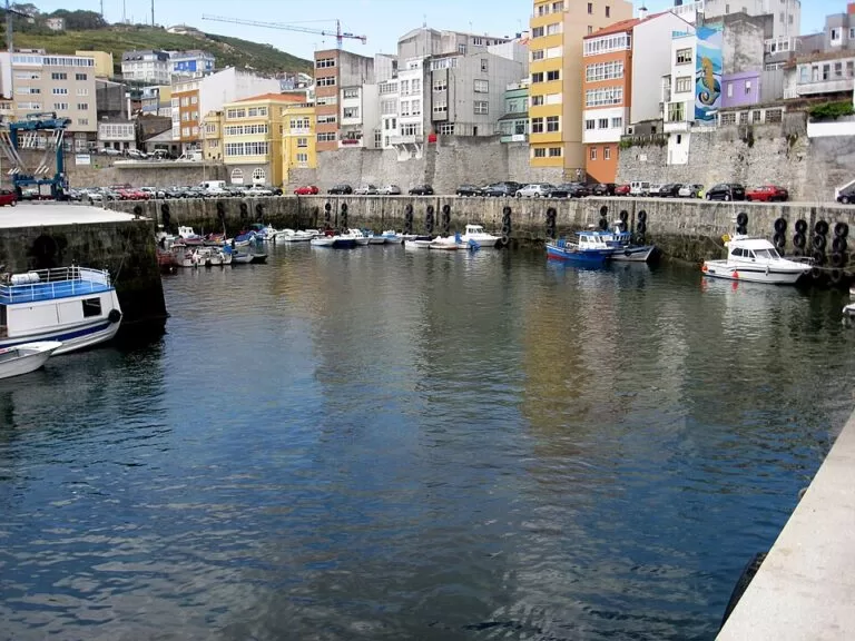
Malpica is a town that lives from the sea. Galician Wikipedia says its economy was based on whaling in the early 17th century, with whale bones still visible as beams in old houses, followed by inshore fishing and canning; the harbour, still called a ribeira, is busy with the fishing fleet, and OpenStreetMap shows the fish market (lonxa) and the fishermen’s guild on the quay.
Behind the harbour, on the other side of the peninsula, a promenade runs along Area Maior, which Galician Wikipedia describes as a meeting place for surfers all year round. In the centre, the Casa do Pescador holds murals by the Galician painter Urbano Lugrís, full of sea creatures, legends of the sea and a compass rose (Spanish Wikipedia).
North-west of the town, past the small beach of Seaia, the chapel of Santo Hadrián stands on Cabo San Adrián, about 2.5 km away, with a viewpoint listed by Turismo de Galicia. On the first Sunday after 16 June a pilgrimage carries the saint’s image about four kilometres from the parish church to the chapel. Tradition says Santo Hadrián cures warts: after mass, pilgrims wash their hands at the fountain and leave a cloth to dry beside it (Galician Wikipedia).
Facing the cape are the Sisargas Islands: Sisarga Grande, Sisarga Chica and Malante, with islets around them. The first lighthouse was built in 1853. The islands are a Special Protection Area for birds within the Costa da Morte Natura 2000 site, with colonies of lesser black-backed, yellow-legged and kittiwake gulls (Spanish Wikipedia). We could not confirm any regular boat trips to the islands.
About 8 km west, near the village of Barizo, the Punta Nariga lighthouse was the last lighthouse built in Spain. Designed by the architect César Portela, it is an angular tower on a sharp, rugged outcrop (Turismo de Galicia). It is built of pink granite from O Porriño, looks like three parts of a huge ship joined together and rises 50 m above the sea (Turismo de Galicia).
Inland, Buño, about 6.5 km south-east, is today the largest pottery centre in Galicia, with around twenty potters, some making traditional pieces and others modern designs. Its ten-day Mostra da Olería includes exhibitions at the Casa do Oleiro (Turismo de Galicia).
Beaches
Lengths and types as Turismo de Galicia gives them, checked November 2026.
- Area Maior – the town beach: 800 m of fine sand, open to the sea, with a Blue Flag (Turismo de Galicia).
- Seaia – a 350 m open beach on the way to Cabo San Adrián (Turismo de Galicia).
- Beo – a 450 m sheltered beach further west (Turismo de Galicia).
- Barizo – a 250 m sheltered beach by the small natural harbour of Barizo, on the road to Punta Nariga (Turismo de Galicia). Galician Wikipedia says the port already appears in 15th-century records.
Practical details
- Where to stay: several small hotels and guesthouses around the harbour and the beach are mapped on OpenStreetMap. Book ahead for July and August.
Accessibility and safety
The promenade and the harbour are flat; the old streets are steep. Area Maior is an open beach and Turismo de Galicia says the Costa da Morte has strong currents and sudden storms, so check the flag before swimming. Capes such as San Adrián and Nariga are exposed to wind; keep away from the cliff edges. In an emergency, call 112.
Best time to visit
Summer for the beach, with the Festa do Mar at the end of August, when decorated boats carry the Virxe do Carme out to the Sisargas (Galician Wikipedia). June brings the Santo Hadrián pilgrimage; spring and autumn are quieter for the capes.
Nearby alternatives
- A Coruña, 34 km east: the city’s old town, glazed galleries and beaches.
- Tower of Hercules, 33 km east: the Roman lighthouse, a UNESCO World Heritage site.
- Camariñas, 37 km south-west: the bobbin-lace town on its ría.
- Cabo Vilán Lighthouse, 37 km south-west: the first electric lighthouse in Spain.
- Muxía, 41 km south-west: the Virxe da Barca sanctuary on the rocks.
Distances are in a straight line from the centre of Malpica.
FAQ
Where is Malpica de Bergantiños?
At the northern end of the Costa da Morte in A Coruña province, about 34 km west of A Coruña in a straight line.
Can you swim in Malpica?
Yes. Area Maior, the 800 m town beach, has a Blue Flag. It is open to the sea, so check the flag; Beo and Barizo, to the west, are more sheltered.
Can you visit the Sisargas Islands?
We could not confirm any regular public boat service to this protected bird area; see them from Cabo San Adrián or the seafront.
What is the Punta Nariga lighthouse?
The last lighthouse built in Spain, designed by César Portela in pink granite on a rocky outcrop near Barizo, about 8 km west of Malpica.
Is Malpica good for surfing?
Galician Wikipedia describes Area Maior as a meeting place for surfers all year round.
Sources and freshness
Checked 9 November 2026 · 9 sources Show
Checked 9 November 2026. Official: Turismo de Galicia on the Costa da Morte (municipalities, Buño pottery museum, Sisargas), Punta Nariga, the lighthouses and wild beaches route, the Mostra da Olería de Buño, the Cabo San Adrián viewpoint and the beaches linked above. Background: Galician Wikipedia on Malpica de Bergantiños (history, festivals, fountains, surfing) and Spanish Wikipedia (population, Casa do Pescador, San Adrián pilgrimage), and Spanish Wikipedia on the Sisargas Islands. Location, parking and distances: OpenStreetMap contributors (ODbL). The town hall website could not be reached. Photo: Wikimedia Commons, licence as credited.
How this page is made. CostaMap is written with an AI editorial system run by Ebizapple. This page is based on the sources listed above. Last updated 9 November 2026. Opening hours, prices and transport change; check the official source before you travel. How we work · Partner links and ads