
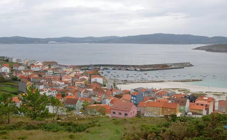
Laxe is a fishing town on the Costa da Morte in Galicia, on the south shore of the Corme and Laxe ría, about 19 km west of Malpica and 17 km north-east of Camariñas in a straight line. Its sheltered town beach runs along the whole centre, and from the harbour you can walk to the Laxe lighthouse, the Museo do Mar and, a short drive away, the wild beaches of Soesto and Traba. It suits families who want a calm beach, people touring the Costa da Morte by car and anyone curious about its fishing history; skip it if you want big-resort nightlife.
Quick facts
- Names: Laxe in Galician (official); Lage in Castilian, as Spanish Wikipedia lists it. The name comes from the early medieval form lagena, probably of Celtic origin (Galician Wikipedia).
- Where: municipality of Laxe, comarca of Bergantiños, province of A Coruña, on the southern side of the Corme and Laxe ría. About 52 km in a straight line west of A Coruña Airport.
- Coordinates: 43.2219, -9.0059 (town centre, OpenStreetMap).
- Population: 2,977 in the whole municipality (IGE 2022, via Galician Wikipedia).
- Town beach: Praia de Laxe, a sheltered beach of fine sand with a Blue Flag; Turismo de Galicia’s beach record gives 1,320 m, while its town and ría pages speak of 1,400 m and “almost two kilometres”.
- Festival: a pilgrimage to the shrine of Santa Rosa de Lima on 30 August (Turismo de Galicia).
Access and parking
By car: Laxe is reached on local roads; Santiago de Compostela Airport (SCQ) is about 60 km and A Coruña Airport (LCG) about 52 km away in a straight line.
Parking: OpenStreetMap shows several small free street-side parking areas around the church of Santa María da Atalaia and along the seafront, most with five or six spaces, and more along the streets behind the beach. We found no large mapped car park in the centre, so in July and August expect to park on the edge of town and walk in.
Without a car: we could not confirm current bus routes or timetables to Laxe. Check with the regional bus operators before you plan a trip without a car.
What to expect
Turismo de Galicia presents Laxe as proof that the Costa da Morte is not only cliffs: the sea calms inside the ría, by the long town beach (Turismo de Galicia). The harbour still works: OpenStreetMap shows the fish market (lonxa) and the Aula do Mar fishing-culture point on the quay.
Walking through the streets you pass the Casa do Arco, which joins two buildings with an arch and shows the coats of arms of Galicia and of the Moscoso family, with several 15th- and 16th-century inscriptions. The parish church of Santa María da Atalaia stands right by the port; Turismo de Galicia dates it to the 15th century and notes its fortified atrium (Turismo de Galicia). Galician Wikipedia says the crew of the English ship Adelaide, wrecked in the bay on 19 December 1830, were buried near it.
The Museo do Mar de Laxe, a municipal museum at Rúa Pracer 5, covers the anthropological, historical and visual heritage of Laxe and the districts of Bergantiños and Soneira from the end of the 19th century to the 1970s. It holds some 67,000 photographs from the archive of the photographer Plácido Vidal and his son José María Vidal (Turismo de Galicia).
North of the town, the Laxe lighthouse is a white cylindrical tower 11 m high on a small rise 50 m above the sea, with a light visible from 14 miles away. Turismo de Galicia gives the walk: pass under the Casa do Arco to the church, then take Rúa do Hospital and the cemetery lane to an earth track that leads to the lighthouse (Turismo de Galicia). It is about 1.2 km from the centre in a straight line.
A few metres from the town, on a gentle hill, is the shrine of Santa Rosa de Lima; Turismo de Galicia says a well-known pilgrimage takes place there every 30 August.
Beaches
- Praia de Laxe – the town beach, sheltered inside the ría, with fine sand and a Blue Flag, 1,320 m long on Turismo de Galicia’s beach record (Turismo de Galicia). Galician Wikipedia lists showers, lifeguards, ramps, a promenade and a Red Cross post.
- Soesto – an open beach of 860 m of fine sand, about 1.4 km west of the centre (Turismo de Galicia). Turismo de Galicia warns that it is likely to meet you with strong wind and swell; you leave the car nearby and cross the dunes on walkways (Turismo de Galicia). Galician Wikipedia says it suits surfing and hosts Spanish championship events at the end of August.
- Traba – an open beach of 2,630 m, about 4.7 km south-west of Laxe, backed by dunes and a coastal lagoon, with seabirds such as plovers and wagtails among the reeds (Turismo de Galicia).
Behind Traba rise the Penedos de Pasarela e Traba, a Protected Landscape of wind-carved granite. Four peaks up to 274 m surround the Traba valley; you can walk up from Traba or from Pasarela, in Vimianzo (Turismo de Galicia).
Practical details
- Museum hours and prices: not confirmed on an official page; Turismo de Galicia lists museo@laxe.es.
- Barnacles: Punta do Roncudo near Corme, 6 km away, is the famous spot.
- Where to stay: Laxe has small hotels and guesthouses in the centre and by the beach, shown on OpenStreetMap. Book ahead for July and August.
Accessibility and safety
The town beach is the easy option: flat, in the middle of town, and Galician Wikipedia lists ramps and lifeguards in season. Soesto and Traba are reached over dunes on walkways and face the open Atlantic; Turismo de Galicia says the Costa da Morte has strong currents and sudden storms, so swim on the sheltered town beach unless conditions are calm and you know the sea. In an emergency, call 112.
Best time to visit
Summer is the beach season, ending with the Santa Rosa de Lima pilgrimage on 30 August. Spring and autumn are quieter for the lighthouse walk and the Penedos; bring rain gear.
Nearby alternatives
- Camariñas, 17.5 km south-west: the bobbin-lace town and its Lace Museum.
- Cabo Vilán Lighthouse, 18 km south-west: the first electric lighthouse in Spain.
- Malpica de Bergantiños, 19 km north-east: fishing port, surf beach and the Sisargas Islands.
- Muxía, 21.5 km south-west: the Virxe da Barca sanctuary.
Distances are in a straight line from the centre of Laxe.
FAQ
Is Laxe beach good for swimming?
Yes. It is a sheltered beach inside the ría with fine sand and a Blue Flag, in the middle of the town. Soesto and Traba, nearby, are open to the Atlantic and often windy.
Is there parking in Laxe?
Yes, mostly free street-side parking around the church and the seafront (OpenStreetMap). In summer, arrive early.
How do you get to the Laxe lighthouse?
On foot from the town: pass under the Casa do Arco to the church of Santa María da Atalaia, follow Rúa do Hospital and the cemetery lane, then an earth track to the lighthouse, about 1.2 km from the centre.
What is there to see in Laxe?
The town beach, Santa María da Atalaia, the Casa do Arco, the Museo do Mar, the lighthouse and, nearby, Soesto, Traba and the Penedos.
How far is the Dolmen de Dombate from Laxe?
About 4.6 km in a straight line, in Borneiro (Cabana de Bergantiños), with an interpretation centre.
Sources and freshness
Checked 9 November 2026 · 14 sources Show
Checked 9 November 2026. Turismo de Galicia on the town of Laxe, the Corme and Laxe ría, the beaches of Laxe, Soesto and Traba, the lighthouse, the Museo do Mar, the Penedos de Pasarela e Traba, the Dolmen de Dombate, the lighthouses and wild beaches route and the Costa da Morte. Background: Galician Wikipedia on Laxe (history, population, beach services, place name) and Spanish Wikipedia (Castilian name). Location, parking, fish market and distances: OpenStreetMap contributors (ODbL). The town and museum websites could not be reached. Photo: Wikimedia Commons, licence as credited.
How this page is made. CostaMap is written with an AI editorial system run by Ebizapple. This page is based on the sources listed above. Last updated 9 November 2026. Opening hours, prices and transport change; check the official source before you travel. How we work · Partner links and ads