
Cala del Barranc d’Aigües (El Campello)
CoveCala del Barranc d’Aigües is a natural pebble beach in El Campello (Alicante), on the Costa Blanca north of Alicante, at the foot of a small cliff below the Lloma de Reixes and the ruined 16th-century Torre de Reixes. It is about 5.7 km north-east of El Campello town in a straight line, in the Coveta Fumà area, and the nearest TRAM stop, Cala Piteres on line L1, is about 0.8 km away. Dogs are allowed in an area at the far end, and the beach is open to them all year. It suits dog owners, walkers and people who want an unbuilt shore; skip it if you need sand, lifeguards or a beach bar.
Quick facts
- Names: Cala del Barranc d’Aigües or Platja del Barranc d’Aigües in Valencian; in Spanish it is sometimes given as Barranco de Aguas. Like the headland and the tower, it takes its name from the Barranc d’Aigües, a stream bed in El Campello.
- Where: El Campello, l’Alacantí, Alicante province, by the Avinguda d’Amèrica in Coveta Fumà. The headland at its north end is the Punta del Barranc d’Aigües.
- Coordinates: 38.4560, -0.3445.
- Type: natural (virgin) beach of gravel and pebbles, listed by the regional tourist board as a cove with a pet-friendly area.
- Size: OpenStreetMap maps the beach as a strip about 740 m from end to end. No official length or width could be found.
- Dogs: allowed in the area at the far end; the beach is open to pets all year (Comunitat Valenciana tourist board).
- Water quality: the regional environment department does not monitor it as an official bathing zone.
- Entry: free.
Access and parking
By TRAM: the nearest stop is Cala Piteres, on TRAM line L1 between Alicante (Luceros) and Benidorm, run by FGV. It is about 0.8 km south-west of the beach in a straight line, next to the small Cala Piteres (OpenStreetMap). The tourist board describes Cala Piteres as easy to reach by tram because it has its own stop (Comunitat Valenciana, Cala Piteres). From there, walk north-east along the coast.
By car: the beach lies below the residential Avinguda d’Amèrica in Coveta Fumà. The main coast road, the N-332 (Carretera de Cartagena a Valencia), runs about 0.7 km inland. Unpaved tracks and paths lead down to the shore from the road. The TRAM line runs close behind the beach, with a level crossing about 0.3 km away.
Parking: OpenStreetMap shows no car park at the beach. The nearest mapped car park is near Cala Piteres, about 0.9 km away. Expect roadside parking in the residential streets above, and check the signs.
What to expect
The regional tourist board describes the Barranc d’Aigües beach as a natural spot known for its preserved surroundings and its pebbles, set beneath a small cliff next to the Lloma de Reixes (Comunitat Valenciana, Barranc d’Aigües). Its service list for the beach gives gravel and pebbles, a virgin beach, a cove and a pet-friendly area, and nothing more. There is no mention of lifeguards, toilets, showers or a beach bar.
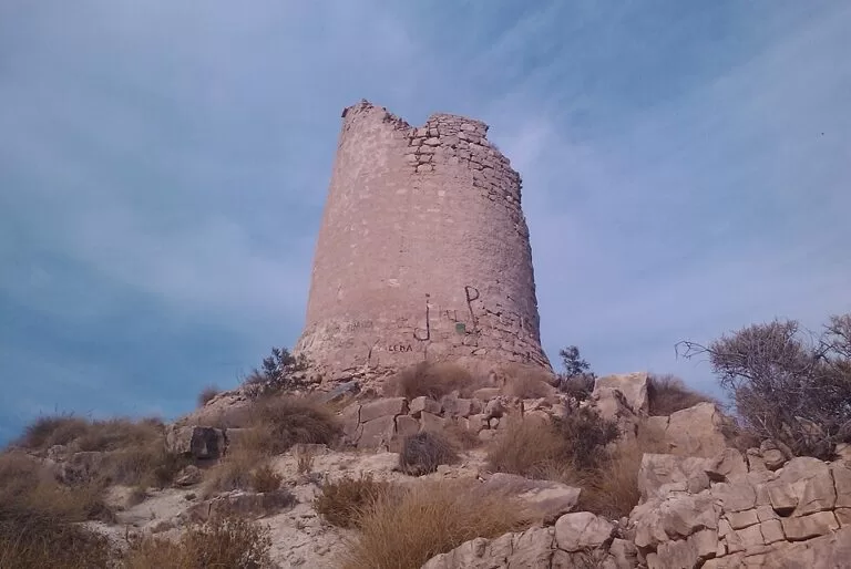
The landmark is the Torre de Reixes, also called the Torre del Barranc d’Aigües, about 0.7 km north-east of the beach on the Lloma de Reixes. It was built in 1554 against Berber pirates, as part of a chain of watchtowers along the Valencian coast (Comunitat Valenciana, the tower). It is a round tower of rubble stone, about 8 m across at the base and 10 m high, which reported to the Santa Bárbara castle in Alicante. The top has gone, and on 4 May 2021 it was put on the Lista Roja of heritage at risk of collapse (Wikipedia, Torre de Aguas). The tower is a listed monument (Bien de Interés Cultural).
The place also has a border history. The tourist board says the area was the frontier between the kingdoms of Castile and Aragon until 1296. In the Treaty of Almizra, the line from Biar through Busot to El Campello followed the Barranc d’Aigües, and the land south of it was reserved for Castile (Wikipedia, Treaty of Almizra).
Next door, the Les Llomes de Reixes beach is a pebble cove under a cliff, with a snorkelling route over its rocky seabed. The tourist board lists it as naturist. At one end it joins the Barranc d’Aigües beach (Comunitat Valenciana, Les Llomes de Reixes).
Practical details
- Dogs: bring your dog to the area at the far end of the beach, as the tourist board says. We could not find El Campello’s own rules for this area (numbers of dogs, papers, leads). The town hall site was not reachable, so check the signs on site.
- Shoes: the beach is gravel and pebbles, so bring water shoes.
- Shade, water and food: bring your own. The tourist board lists no services.
- Tourist office: El Campello tourist information, +34 965 634 606, turismo@elcampello.org (contact listed by the regional tourist board).
Accessibility and safety
This is not a supervised bathing zone. The regional environment department does not monitor the water here, and no lifeguard service is listed. The way down is on unpaved tracks and paths, and the pebbles are uneven underfoot, so we could not confirm step-free access. The tower is at risk of collapse: look at it from a distance and do not climb on it.
Best time to visit
For dog owners, any time of year: the beach is open to pets all year. For swimming, the calm, warm months suit best, but go knowing there are no services. A visit pairs well with a walk up to the tower, or with the archaeological site of the Illeta dels Banyets, which the tourist board suggests for the same day out.
Nearby alternatives
- Torre de la Illeta (El Campello), 4.3 km away: another coastal watchtower on the El Campello shore, nearer the town.
- Canelobre Caves, 8.4 km away: a show cave inland, for a day when the sea is rough.
- Villajoyosa (La Vila Joiosa), 11.1 km away: the next town up the coast.
- Cala del Racó del Conill, 15.8 km away: another natural cove north of Villajoyosa.
- Playa del Postiguet (Alicante), 16.7 km away: Alicante’s city beach below the castle, if you want sand and services.
- Cala Piteres, about 0.9 km south-west: a small cove by the TRAM stop, which the tourist board suggests for snorkelling.
Distances are in a straight line from the beach.
FAQ
Where is Cala del Barranc d’Aigües?
In El Campello, Alicante, in the Coveta Fumà area about 5.7 km north-east of the town centre, below the Lloma de Reixes and its watchtower. Coordinates: 38.4560, -0.3445.
Are dogs allowed at Barranc d’Aigües beach?
Yes. The regional tourist board says the beach has a dog-friendly area at the far end and is open to pets all year. Check the signs for local rules.
How do I get to Cala del Barranc d’Aigües by public transport?
Take TRAM line L1 (Alicante–Benidorm) to the Cala Piteres stop, about 0.8 km from the beach, and walk north-east along the coast.
Is there parking at Barranc d’Aigües?
OpenStreetMap shows no car park at the beach itself. The nearest mapped car park is near Cala Piteres, about 0.9 km away; otherwise park in the residential streets above.
Is it a sandy beach?
No. It is gravel and pebbles, with no services listed, so bring water shoes, shade and water.
Sources and freshness
Checked 6 November 2026 · 8 sources Show
Checked 6 November 2026. Official: the Comunitat Valenciana tourist board on the Barranc d’Aigües beach (surface, setting, dogs, services, water monitoring, tourist office contact), Les Llomes de Reixes (pets all year, snorkelling, naturist), Cala Piteres, the Torre del Barranc d’Aigües (1554, frontier until 1296) and El Campello. Background: Wikipedia on the tower (size, Lista Roja 2021) and the Treaty of Almizra. Location, size, TRAM stop, roads, parking and distances: OpenStreetMap. El Campello town hall’s website could not be reached, so local dog rules and any summer services are not covered.
This place is part of our Costa Blanca, Spain: towns, beaches and where to stay — see every town, beach and cove we have mapped on that coast.
How this page is made. CostaMap is written with an AI editorial system run by Ebizapple. This page is based on the sources listed above. Last updated 6 November 2026. Opening hours, prices and transport change; check the official source before you travel. How we work · Partner links and ads