
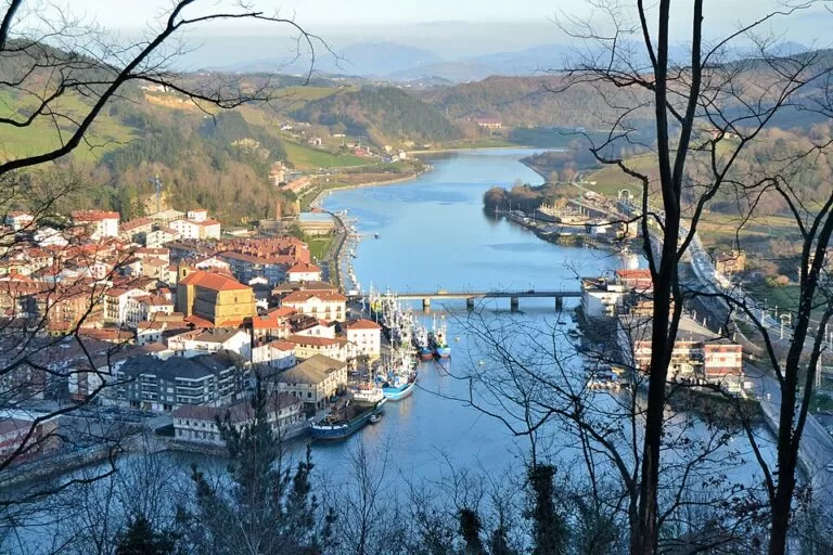
Orio is a fishing village at the mouth of the Oria river in Gipuzkoa, 12 km west of San Sebastián in a straight line and 4 km east of Zarautz, known for sea bream grilled in the street, its yellow rowing boats and Antilla beach at the river mouth. The Euskotren station (Aia-Orio) is about 200 m from the town hall, so it is easy to reach from San Sebastián or Bilbao. It suits food lovers, families who want a sheltered river-mouth beach and walkers on the coastal path or the Camino de Santiago; skip it if you are looking for nightlife or a long open beach.
Quick facts
- Name: Orio in both Basque and Spanish; the river is the Oria.
- Where: 20810 Orio, Gipuzkoa (Basque Country), on the Oria estuary, between Zarautz to the west and San Sebastián to the east; Aia lies inland.
- Coordinates: 43.2759, -2.1268 (town hall, OpenStreetMap).
- Size: 9.80 km², 5,147 inhabitants (Basque tourism board).
- Old town: Goiko Kale, medieval, protected as a Property of Cultural Interest (spain.info).
- Beaches: Antilla at the river mouth, and the quieter Oribarzar on the opposite bank.
- Known for: grilled sea bream (besugo), elvers (angulas) and rowing.
Getting there and parking
By train: Aia-Orio station, on the Euskotren E1 line between Bilbao and San Sebastián (Donostia-Amara), lies about 200 m south of the town hall (OpenStreetMap). The official coastal path leaflet sends walkers past the station on their way out of town.
By bus: OpenStreetMap shows the Lurraldebus line UK09 between Zumaia and Donostia/San Sebastián through Orio. We could not open the timetable, so check times before you travel.
By car: OpenStreetMap maps several car parks around the centre, one of them marked free, and the Basque tourism board lists parking among the services of Antilla beach. We found no official information on prices. In summer the village gets very crowded, as the tourism board says, so the train is the easier option.
What to see
Goiko Kale, the old town. The historic quarter is a maze of steep, cobbled streets that the Basque tourism board dates to the 12th century. spain.info describes it running from the church of San Nicolás up to the surroundings of the chapel of San Martín, with coats of arms, cut sandstone, brightly coloured balconies and stepped streets climbing the rocks. The parish church of San Nicolás de Bari, in Baroque style, stands at the top of the old town.
The Camino de Santiago. Orio has seen pilgrims pass for centuries and is still on the coastal Way of St James. The chapel of San Martín de Tours and the parish church are, in the tourism board’s words, among the treasures along the route.
The harbour and the grills. Near the port, fish and meat are cooked on grills set up in the street. Sea bream is the signature dish, and on cold winter nights the eel fishermen go out on the river in small boats to catch elvers. The fishing fleet moors in the estuary (official coastal path leaflet).
Rowing. The tourism board says that if Orio is known for one thing, it is its love of rowing: the town’s yellow trainera, the traditional Basque racing boat, has won many races over the years.
Pagoeta Natural Park. In neighbouring Aia, the Pagoeta Natural Park covers 1,335 ha of farmland, farmhouses and woods around Mount Pagoeta. Its visitor centre, Iturraran, is in a 15th-century farmhouse next to a large botanical garden; the park also has the Agorregi ironworks from the early 15th century, old snow pits and several dolmens.
Beaches
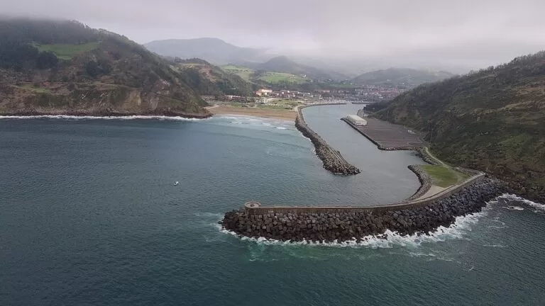
- Antilla – Orio’s main beach, at the mouth of the Oria and sheltered by Mount Kukuarri, about 1.2 km north of the town hall. Rebuilt in 1997, it covers about 3,500 m². Next to it are a park with a playground, a campsite, a promenade and three restaurants. There are surf peaks in the middle of the beach, and a left beside the breakwater that breaks on big days; a local surf club runs courses. Lifeguards 10:30–19:30 in season (Basque tourism board, checked November 2026).
- Oribarzar – on the other side of the estuary, less busy than Antilla and good for quiet walks, according to the tourism board. The coastal path to Zarautz passes it.
Walks
- Orio to Zarautz and Zumaia – the coastal path (GR 121, part of the European E9) runs 16.5 km to Zumaia, with 619 m of climbing and about 5 h 25 min of walking (official leaflet, stage 4). It crosses the river, passes the station and the small San Pablo hermitage, and follows a path with views over the estuary to Oribarzar beach, then climbs through txakoli vineyards to Talaimendi (km 3.5). From there it heads to the coast past the remains of the Malla Harria iron-ore loading dock and down a long flight of steps to Iñurritza, the largest and best-preserved dune field on the Basque coast. A boardwalk over the dunes beside the golf course leads into Zarautz at km 6.8.
- San Sebastián to Orio – the previous stage, 16.3 km with 548 m of climbing and about 5 h 15 min (official leaflet, stage 3), climbs over Mount Igueldo and along the slopes of Mendizorrotz and Kukuarri before dropping into Orio.
Practical details
- Tourist office: Aritzaga kalea 1, tel. +34 943 835 565. It offers guided tours of the old town, boat trips on the Oria and walking, and dogs are welcome. Summer hours (19 June to 15 September): Monday to Saturday 10:00–14:00 and 16:00–20:00, Sunday 10:00–14:00 (Basque tourism board, checked November 2026). Winter and spring hours are shorter and the office is closed on Mondays then.
- Fiestas: San Pedro in June, San Nicolás in December, and Sea Bream Day (Besugo Eguna) in the third week of July.
Accessibility and safety
Goiko Kale is steep, stepped and cobbled, so it is hard going with a wheelchair or pushchair; the riverside and the beach promenade are flatter. Swim at Antilla within lifeguard hours and keep clear of the breakwater and the river channel, where boats pass. We could not confirm adapted facilities at the beach.
Best time to visit
Summer for Antilla beach and the street grills, when the village is at its busiest; the third week of July for Sea Bream Day. Winter is the elver season. Spring and autumn suit the coastal walks.
Nearby alternatives
- Zarautz, 3.2 km away: the 2.5 km surf beach next door, reached on foot by the coastal path.
- Getaria, 7.0 km away: the fishing town of grilled fish, txakoli and the Balenciaga museum.
- Monte Igueldo, 10.7 km away: the viewpoint over San Sebastián at the other end of the coastal path stage.
- Zumaia Flysch, 11.2 km away: the layered cliffs at the end of the walk from Orio.
- San Sebastián, 12.3 km away: the city on La Concha bay, on the same Euskotren line.
Distances are in a straight line from Orio town hall.
FAQ
How do I get to Orio from San Sebastián?
By Euskotren train to Aia-Orio station, about 200 m from the town hall, or by Lurraldebus line UK09. Walkers can follow the coastal path over Mount Igueldo: 16.3 km, about 5 h 15 min.
Is there a beach in Orio?
Yes. Antilla, at the river mouth, has lifeguards from 10:30 to 19:30 in season, a playground, a campsite and restaurants. Oribarzar, across the estuary, is quieter.
What is Orio famous for?
Sea bream grilled in the street near the port, elvers fished in the river in winter, its yellow rowing boats and the medieval old town, Goiko Kale.
Can you walk from Orio to Zarautz?
Yes. The coastal path reaches Zarautz after 6.8 km via Talaimendi and the boardwalk over the Iñurritza dunes.
When is Orio’s Sea Bream Day?
In the third week of July, according to the Basque tourism board.
Sources and freshness
Checked 9 November 2026 · 8 sources Show
Checked 9 November 2026. Official: Basque tourism board on Orio (old town, food, beaches, rowing, fiestas, size), Antilla beach, the tourist office, Pagoeta Natural Park and the Sendero Litoral leaflets for stage 3 and stage 4 (edition 2025). spain.info on Orio (Goiko Kale). The town’s tourism website could not be reached from our research tools. Station, bus line, car parks, coordinates and distances: OpenStreetMap contributors (ODbL). Photos: Wikimedia Commons, licences as credited.
How this page is made. CostaMap is written with an AI editorial system run by Ebizapple. This page is based on the sources listed above. Last updated 9 November 2026. Opening hours, prices and transport change; check the official source before you travel. How we work · Partner links and ads