
Els Muntanyans Beach (Platja dels Muntanyans) is the natural dune beach of Torredembarra, on the Costa Dorada about 13 km north-east of Tarragona: a long strip of golden sand backed by dunes and saltwater lagoons, protected as part of the Platja de Torredembarra i Creixell natural area. You reach it on foot from Torredembarra’s Baix a Mar seafront or from the campsites, and Torredembarra railway station is about 1 km from its western end. It suits walkers, birdwatchers and people who want space without a promenade; part of it is used by nudists, and there is little shade.
Quick facts
- Names: Platja dels Muntanyans (Catalan), Playa de los Muntanyans (Spanish); the protected area is the Espai Natural Protegit de la Platja de Torredembarra i Creixell.
- Where: Torredembarra (Tarragonès), between Baix a Mar beach to the west and Creixell beach to the east (Viquipèdia).
- Coordinates: 41.1501, 1.4276.
- Size: 2,200 m long and 66 m wide on average, facing south-east (Viquipèdia). Catalunya.com gives four kilometres by 100 m, probably counting the dune beach on into Creixell.
- Sand and water: fine golden sand, a gentle slope and warm, calm water.
- Facilities: lifeguards, foot showers and public toilets (Viquipèdia); Catalunya.com also lists sunshade rental.
- Naturism: a zone of about 400 m is used for nudism (Viquipèdia).
- Protection: in Catalonia’s PEIN plan of natural areas; semi-mobile dunes and saltwater lagoons.
Access and parking
By train: Torredembarra has a station on the coastal line (Catalunya.com calls the service R2 Sud), on the seafront at Baix a Mar (Catalunya.com). From there the western end of the protected beach is about 1 km on foot along the seafront; the middle of the beach is about 2 km from the station in a straight line (OpenStreetMap).
By bus: OpenStreetMap shows local bus stops named Els Muntanyans (E.I.N.) and Càmpings on the road behind the western end of the area. We could not confirm the lines or frequencies.
By car: Catalunya.com says the protected area can be reached by car and has a car park. Residential streets and campsites surround it, so keep to marked parking: driving or parking on the dunes is not an option in a protected area.
On foot: the GR 92 coastal path crosses the protected area. One stage runs from Calafell along the beaches to Creixell, enters the protected area in the middle of Creixell beach, passes the wetlands of Les Antines and Els Muntanyans and ends in Torredembarra; the next stage starts at the southern end of the wetlands and follows the seafront to the port and the lighthouse (Catalunya.com, GR 92).
What to expect
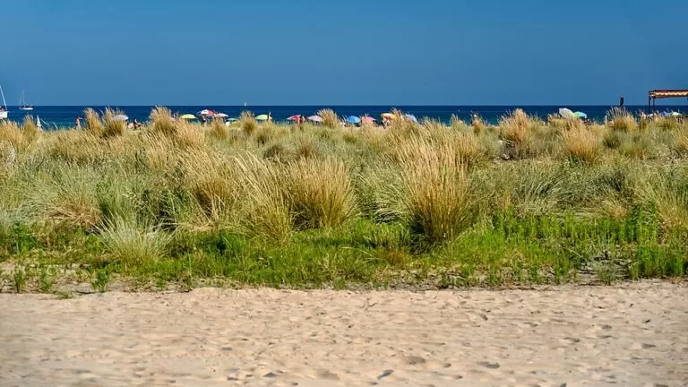
A wide, open beach with low dunes behind it and, further back, lagoons and salt marsh before the railway line. Catalunya.com calls it an almost unique ecosystem of great ecological and scenic value. Plants that are now rare on this coast grow on the dunes, among them the sea lily (endangered) and marram grass, and the lagoons hold salicornia. The Kentish plover breeds here, and migratory birds stop on their way (Catalunya.com, protected area).
The setting is not wild in every direction: Catalunya.com notes that the area is flanked by residential estates and campsites, and that it is highly visited by bathers and people passing through. OpenStreetMap maps two lagoons, Estany de Clarà and Estany del Saler, a bird hide near the western end and several information points. Restaurants, beach bars and the campsites sit along the edges.
Practical details
- Swimming: the Catalan Water Agency checks the water weekly in the bathing season and rated it excellent; the beach is listed with a Blue Flag by Viquipèdia (we could not confirm the current year).
- Toilets and showers: OpenStreetMap places toilets near the western access by the campsites; foot showers are along the beach.
- Naturism: nudists use part of the beach (about 400 m, says Viquipèdia), and clothed bathers use the rest.
- Dogs, fires, camping on the sand: the rules could not be confirmed from an official page; in a protected dune area expect them to be restricted.
- Food: bring water. Catalunya.com mentions restaurants and beach bars around the edges of the area; Torredembarra’s Baix a Mar seafront has more.
Accessibility and safety
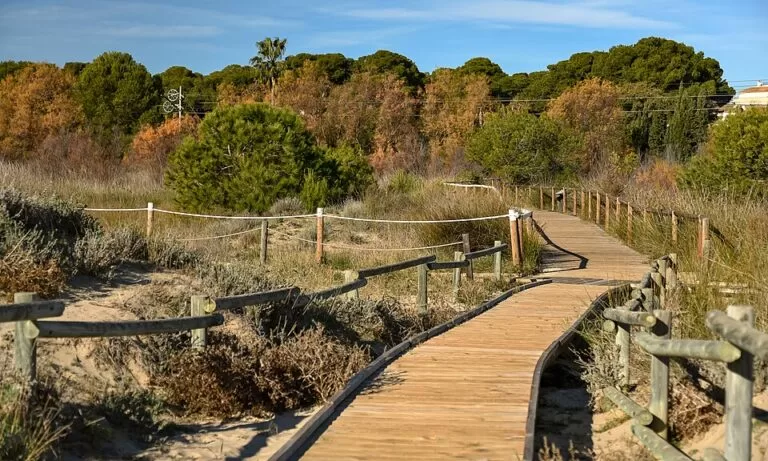
No adapted access is listed for this beach on the pages we could open. A fenced wooden boardwalk crosses part of the dunes (see the photo above, taken in 2020), but beyond it you walk on sand, which is hard going with a pushchair or wheelchair; Torredembarra’s town beaches nearer the station are easier. Keep to the marked paths through the dunes, where the plants and nesting birds are protected. There is little natural shade, and lifeguards work only in the bathing season.
Best time to visit
June to September for swimming; spring and autumn for walking the GR 92 and watching birds, when the beach is quieter. Torredembarra has dry, warm summers, and autumn is its rainiest season (Catalunya.com). The town’s festival of Santa Rosalia falls at the end of August and start of September.
Nearby alternatives
- Torredembarra: the town guide, with the Baix a Mar seafront and old town.
- Altafulla: 4.2 km, the walled village and a calm town beach.
- Arc de Berà: 4.3 km, the Roman arch on the Via Augusta at Roda de Berà.
- Tamarit Beach and Castle: 6.0 km, a natural beach under a medieval castle.
- HolaCamp Sant Salvador: 9.8 km, a campsite by the sea at Coma-ruga.
The whole stretch is covered in our guide to Tarragona, Altafulla and Torredembarra.
FAQ
Is Els Muntanyans a nudist beach?
Partly. A stretch of about 400 m is used for nudism, and the rest of the beach is a normal family beach.
How long is Platja dels Muntanyans?
The Torredembarra beach is 2,200 m long and about 66 m wide. Catalunya.com gives about 4 km, probably counting the dunes on into Creixell.
How do I get to Els Muntanyans from Torredembarra station?
Walk east along the seafront from the station at Baix a Mar; the protected beach starts about 1 km away.
Is there parking at Els Muntanyans?
Yes, Catalunya.com says the protected area can be reached by car and has a car park. If you would rather not drive, the station is about 1 km from the western end.
Can you see birds at Els Muntanyans?
Yes. The Kentish plover breeds here, migratory birds rest in the lagoons, and OpenStreetMap shows a bird hide at the western end.
Sources and freshness
Checked 7 November 2026 · 1 source Show
Checked 7 November 2026. The Torredembarra town and Costa Daurada tourism websites could not be reached from our research setup.
- Catalunya.com: Els Muntanyans beach
- Catalunya.com: Platja de Torredembarra i Creixell protected natural area
- Catalunya.com: GR 92, Calafell to Torredembarra and Torredembarra to Tarragona
- Catalunya.com: Torredembarra
- Viquipèdia: Platja dels Muntanyans and Wikipedia: Torredembarra
- OpenStreetMap: Platja dels Muntanyans (location, lagoons, bird hide, bus stops, station)
This place is part of our Costa Dorada map and travel guide: Roman Tarragona, Salou and the Ebro Delta — see every town, beach and cove we have mapped on that coast.
How this page is made. CostaMap is written with an AI editorial system run by Ebizapple. This page is based on the sources listed above. Last updated 6 November 2026. Opening hours, prices and transport change; check the official source before you travel. How we work · Partner links and ads