
Pont del Diable (Les Ferreres Aqueduct, Tarragona)
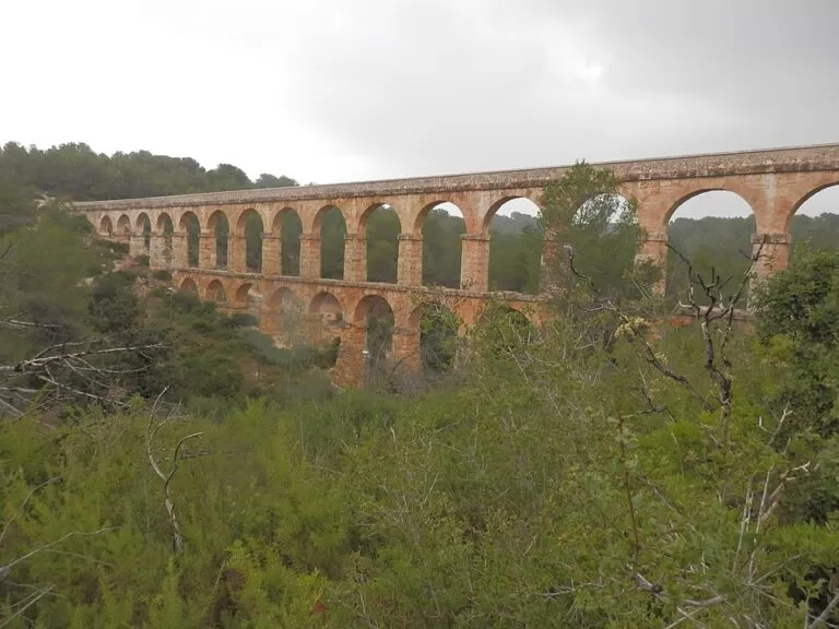
Historic siteThe Pont del Diable (Devil’s Bridge), properly Les Ferreres Aqueduct (Aqüeducte de les Ferreres), is the Roman aqueduct bridge of Tarraco, about 4 km north of Tarragona city centre on the left bank of the Francolí river. Two tiers of stone arches, up to 27 m high, cross a wooded ravine beside the AP-7 motorway; OpenStreetMap shows free car parks within 350 m and a city bus stop named Pont del Diable. It suits anyone following Roman Tarragona; skip it if you only have a few hours in the city, because the monuments in the old town are closer together.
Quick facts
- Names: Pont del Diable (Catalan, “Devil’s Bridge”), Aqüeducte de les Ferreres (Catalan), Acueducto de las Ferreres or Puente del Diablo (Spanish).
- Where: on the left bank of the Francolí, about 4 km north of Tarragona, next to the AP-7 motorway and the N-240 road.
- Coordinates: 41.1460, 1.2439.
- What it is: the best-known surviving bridge of the aqueduct that brought water from the Francolí to Tarraco (Catalunya.com).
- Size: two levels of arches, 25 above and 11 below; up to 27 m high and 249 m long including the ends where the water channel runs on a wall (Wikipedia). Catalunya.com gives “over two hundred metres”.
- Date: probably from the time of Emperor Augustus (Wikipedia).
- Status: part of the Archaeological Ensemble of Tarraco, a UNESCO World Heritage Site since 2000.
- Setting: the centrepiece of the Parc Ecohistòric del Pont del Diable, a park with early 20th-century Romantic-style gardens (Catalunya.com).
Access and parking
By car: the aqueduct stands right beside the AP-7, whose exit 33 leads into Tarragona (Catalunya.com). OpenStreetMap maps a rest area called Pont del Diable about 150 m south-west of the bridge, with several free surface car parks, and a second free car park, Aparcament de l’Aqüeducte, about 350 m to the west. Check which side of the road you are on before you leave the car: the motorway and the N-240 split the area.
By bus: OpenStreetMap shows an EMT Tarragona city bus stop named Pont del Diable about 350 m west of the bridge. Spain.info says many EMT routes start from Plaça Imperial Tarraco and that most city routes run between 6 am and 11 pm (Spain.info). We could not confirm which line serves the stop; ask at the bus station or check EMT before you go.
What to expect
The bridge appears suddenly in the middle of the woodland, as Catalunya.com puts it, and it is the reason most people come. OpenStreetMap names the ravine below the arches the Barranc del Diable, and Catalunya.com describes the setting as a showcase of Mediterranean biodiversity. The park around it adds the Romantic-style gardens laid out by the Puig i Valls brothers at the beginning of the 20th century; OpenStreetMap also marks the ruins of their winery (Bodega de Puig i Valls) and the farm of Mas dels Arcs about 500 m north-east of the bridge.
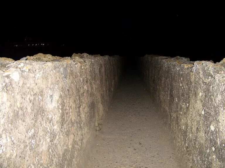
The arches all have the same span, 20 Roman feet (about 5.9 m), with pillars set 26 Roman feet apart (Wikipedia). On top runs the specus, the open stone channel that carried the water. Photos on Commons show people standing in it, but we found no official page saying whether walking on top is allowed today, so follow the signs on site.
A company called Limonium runs the cultural programme of the park, with daytime and night-time guided tours, games and other activities (Catalunya.com). We could not open its own website to check dates and prices.
Prices and opening
None of the official pages we could open gives an entry price or opening hours for the aqueduct, and OpenStreetMap tags the monument as open to the public (access=yes) without a fee. Treat it as an open-air site and check locally for guided-tour prices. The other parts of the World Heritage ensemble in the city, such as the amphitheatre, are ticketed by the city’s history museum.
Accessibility and safety
From the car parks you walk on paths through the woodland; we could not confirm the surface or whether the route is step-free. OpenStreetMap shows benches along the path near the bridge and two drinking-water taps by the Casa del Guarda, the keeper’s house, about 200 m west of it. The ravine sides are steep and the channel on top has no railing, so keep children close. The motorway is next to the site: cross roads only where marked.
Best time to visit
Tarragona has a maritime Mediterranean climate with dry, warm summers and mild winters; autumn is the rainiest season (Catalunya.com). Spring and autumn are the comfortable times for the walk from the car park. In May the city holds Tarraco Viva, its Roman festival with re-enactments and guided routes (Spain.info), which is a good time to combine the aqueduct with the monuments in town.
Nearby alternatives
- Roman Villa of Centcelles: 1.8 km, the 4th-century villa in Constantí with its dome mosaic, also part of the World Heritage ensemble.
- Tarragona Cathedral: 3.2 km, at the top of the old town.
- National Archaeological Museum of Tarragona: 3.5 km, for the finds from Tarraco.
- Tarragona Amphitheatre: 3.7 km, the Roman arena above the sea.
- Tarragona: the city guide, 3.0 km to its centre point.
The whole stretch of coast is covered in our guide to Tarragona, Altafulla and Torredembarra.
FAQ
How do I get to the Pont del Diable in Tarragona?
It is about 4 km north of the centre, beside the AP-7 motorway. Drivers can use the free car parks that OpenStreetMap marks within 350 m; without a car, an EMT city bus stop called Pont del Diable is about 350 m away.
Is there parking at the Devil’s Bridge?
Yes. OpenStreetMap shows free surface car parks at the Pont del Diable rest area, about 150 m from the bridge, and a free car park, Aparcament de l’Aqüeducte, about 350 m to the west.
Do you need tickets for Les Ferreres Aqueduct?
We found no official ticket price for the aqueduct itself; OpenStreetMap marks it as open to the public. Guided day and night tours of the park are run by Limonium, for which prices could not be confirmed.
How big is the Pont del Diable?
It has two tiers of arches, 25 above and 11 below, a maximum height of 27 m and a length of 249 m including its ends.
Why is it called the Devil’s Bridge?
Pont del Diable is the popular name; several bridges in Catalonia carry it, among them a Roman bridge in Martorell. The official pages we opened do not tell the story behind the Tarragona name, so we leave the legend out.
Sources and freshness
Checked 7 November 2026 · 1 source Show
Checked 7 November 2026. The Tarragona tourist office website could not be reached from our research setup, so opening hours and tour prices are not given.
- Catalunya.com: Les Ferreres Aqueduct (Pont del Diable)
- Catalunya.com: Parc Ecohistòric del Pont del Diable
- Catalunya.com: Tarraco, Roman ensemble of Tarragona
- Catalunya.com: Tarragona and Tarragona access
- Spain.info: Tarragona (city buses, Tarraco Viva)
- Wikipedia: Les Ferreres Aqueduct (dimensions, date)
- OpenStreetMap: Aqüeducte de les Ferreres (location, car parks, bus stop, water taps)
This place is part of our Costa Dorada map and travel guide: Roman Tarragona, Salou and the Ebro Delta — see every town, beach and cove we have mapped on that coast.
How this page is made. CostaMap is written with an AI editorial system run by Ebizapple. This page is based on the sources listed above. Last updated 6 November 2026. Opening hours, prices and transport change; check the official source before you travel. How we work · Partner links and ads