
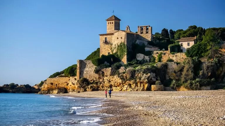
Tamarit Beach (Platja de Tamarit) is the easternmost beach of Tarragona, about a kilometre of golden sand running from the walled Tamarit Castle on its rock to the mouth of the Gaià river and Altafulla beach. It lies about 9 km north-east of Tarragona’s old town; Altafulla-Tamarit railway station is about 1 km away, and the beach has a parking area. Come for a calm, natural beach under a medieval castle and the coastal path south; skip it if you want a promenade with bars, or if you hope to tour the castle, which is private.
Quick facts
- Names: Platja de Tamarit (Catalan), Playa de Tamarit (Spanish); also called Platja del Vinyet and traditionally Platja de la Roca de Gaià (Viquipèdia). The castle is the Castell de Tamarit.
- Where: Tamarit, municipality of Tarragona (Tarragonès), on the boundary with Altafulla.
- Coordinates: 41.1309, 1.3643 (beach); castle 41.1301, 1.3612.
- Size: nearly 1 km long and 45 m wide, says Catalunya.com; Viquipèdia gives 1,150 m by 62 m.
- Sand: fine golden sand with some pebbled areas; calm water, easy to get into.
- Facilities: rescue signs, showers, portable toilets and a parking area (Catalunya.com).
- Flag: listed with a Blue Flag by Viquipèdia; we could not confirm the current year.
- Protection: the coast west of the castle is the Tamarit–Punta de la Móra protected natural area; the river mouth to the east is the Desembocadura del Gaià protected area.
Access and parking
By train: Altafulla-Tamarit station is about 1 km north-east of the middle of the beach on OpenStreetMap. Catalunya.com lists the R14 for Altafulla (Catalunya.com); check the timetable, as not every regional train stops there.
By bus: OpenStreetMap shows EMT Tarragona city bus stops named Castell de Tamarit on Passeig de l’Esquirol, about 1.3 km north-west of the beach, and other EMT stops (Blauet, Esquirol) in the Tamarit area. We could not confirm the line numbers.
By car: Catalunya.com says the beach has a parking area for vehicles. The road to the castle runs through the campsite area; on OpenStreetMap the car parks inside the campsites are marked for guests only, so use the public parking and do not drive into the campsite grounds.
On foot: the GR 92 coastal path from Torredembarra to Tarragona crosses this beach. Walking south, it goes round the castle and follows the camí de ronda, the old coastal path, to La Móra beach (Catalunya.com, GR 92 stage).
What to expect
A natural beach rather than a resort one. Behind it are fields, a campsite and the mouth of the Gaià; at its west end the rock with Tamarit Castle and its small walled village closes the bay. Catalunya.com describes the area as being of ecological interest, with white pines and waterfowl, and part of one nature complex with Platja Llarga, the Bosc de la Marquesa woods and the Gaià mouth.
At the east end, near the Gaià, is a small rock, the Roca de Gaià, where a bunker was built in the Spanish Civil War. A breakwater built in 1991 parallel to the shore made the sand pile up in front of the rock, and the dunes formed there are a nesting site for the Kentish plover; a magnesium carbonate factory that stood beside the beach from 1947 was demolished in 2021 (Viquipèdia).
The castle: Tamarit Castle stands on a promontory between Tamarit beach and the cove of Cala Jovera, and its walls enclose the old walled village. It mixes Romanesque, Gothic and Renaissance work. In 1916 the archbishop of Tarragona sold it to the American magnate Charles Deering, who had it restored in a romantic style by the painter Ramon Casas and Joan Ruiz. Today it belongs to a property company that rents it for private events such as concerts and weddings (Viquipèdia), so treat it as a sight from the outside. Of the four gates in the wall two survive, those of La Móra and La Creu.
The place has a long history. In the 11th century Tamarit was the southernmost castle district of the County of Barcelona, and in the Middle Ages its harbour was among the main ones in Catalonia; ships for the conquest of Mallorca left from here. Rain and Gaià water that stood in pools caused malaria, and the village was gradually abandoned in the 19th century (Viquipèdia). Catalunya.com’s Tarragona page dates the castle to 1363, while its protected-area page calls it Romanesque in origin; the first written records are older than 1363.
Practical details
- Swimming: calm, warm water with an easy entry, according to Catalunya.com. The Catalan Water Agency checks the water weekly in the bathing season (Viquipèdia).
- Food: there is no promenade here. OpenStreetMap marks a restaurant, an ice-cream stand and a supermarket in the campsite zone behind the castle; whether they serve non-guests could not be confirmed. Altafulla’s seafront is about 1.7 km east.
- Staying: campsites back the beach. CostaMap covers Tamarit Beach Resort, 0.4 km away.
- Nature: the Desembocadura del Riu Gaià protected area is a small strip of reeds and marsh where migratory birds rest; the Hort de la Sínia association runs environmental education there (Catalunya.com).
Accessibility and safety
Catalunya.com lists rescue signs and basic services but no adapted access for this beach (it does list them for neighbouring Altafulla). Expect sand and some pebbles. The path round the castle and along the camí de ronda is uneven and runs above the rocks in places: wear proper shoes. Catalunya.com does not list a lifeguard service for this beach, so take care with children in the water.
Best time to visit
June to September for swimming. Outside summer the beach is quiet and good for walking the coastal path; Tarragona’s climate has dry, warm summers, mild winters and the most rain in autumn (Catalunya.com).
Nearby alternatives
- Altafulla: 1.7 km, the next beach and the walled old town.
- Tamarit Beach Resort: 0.4 km, the campsite behind the beach.
- Els Muntanyans Beach (Torredembarra): 6.0 km, dunes and lagoons further north-east.
- Tarragona Amphitheatre: 9.0 km, Roman Tarraco on the sea.
- Arc de Berà: 10.0 km, the Roman arch on the Via Augusta.
The whole stretch is covered in our guide to Tarragona, Altafulla and Torredembarra.
FAQ
Can you visit Tamarit Castle?
Not as a museum. The castle is privately owned and rented out for private events such as weddings and concerts. You can see the walls from the beach and from the coastal path that goes round it.
Is there parking at Tamarit Beach?
Yes, Catalunya.com lists a parking area. The car parks inside the campsites are for guests only.
How do I get to Tamarit Beach without a car?
Take the train to Altafulla-Tamarit station, about 1 km from the beach, or walk the GR 92 coastal path from Altafulla or from Tarragona’s Platja Llarga.
Is Tamarit Beach good for children?
The water is calm with an easy entry, and there are showers and portable toilets, but few other services; families who want bars and play areas will do better at Altafulla.
Is there a nudist beach near Tamarit?
Yes, but not this one. Catalunya.com says nudism is permitted at Cala Fonda, also called Waikiki, in the Tamarit–Punta de la Móra protected area south-west of the castle.
Sources and freshness
Checked 7 November 2026 · 1 source Show
Checked 7 November 2026. Beach sizes differ between sources; we give both.
- Catalunya.com: Tamarit beach
- Catalunya.com: Tamarit–Punta de la Móra protected natural area
- Catalunya.com: Desembocadura del Riu Gaià protected area
- Catalunya.com: GR 92, Torredembarra to Tarragona
- Catalunya.com: Tarragona and Altafulla
- Viquipèdia: Platja de Tamarit and Castell de Tamarit
- OpenStreetMap: Platja de Tamarit (location, station, bus stops)
This place is part of our Costa Dorada map and travel guide: Roman Tarragona, Salou and the Ebro Delta — see every town, beach and cove we have mapped on that coast.
How this page is made. CostaMap is written with an AI editorial system run by Ebizapple. This page is based on the sources listed above. Last updated 6 November 2026. Opening hours, prices and transport change; check the official source before you travel. How we work · Partner links and ads